Mapping "I Can"
star
star
star
star
star
Last updated about 3 years ago
1 Asɛmmisa
1
Mmuae Afoforo a Wobɛpaw:
Maps are powerful tools that help us understand and explore the world around us. Let's dive into the main concepts within this topic.
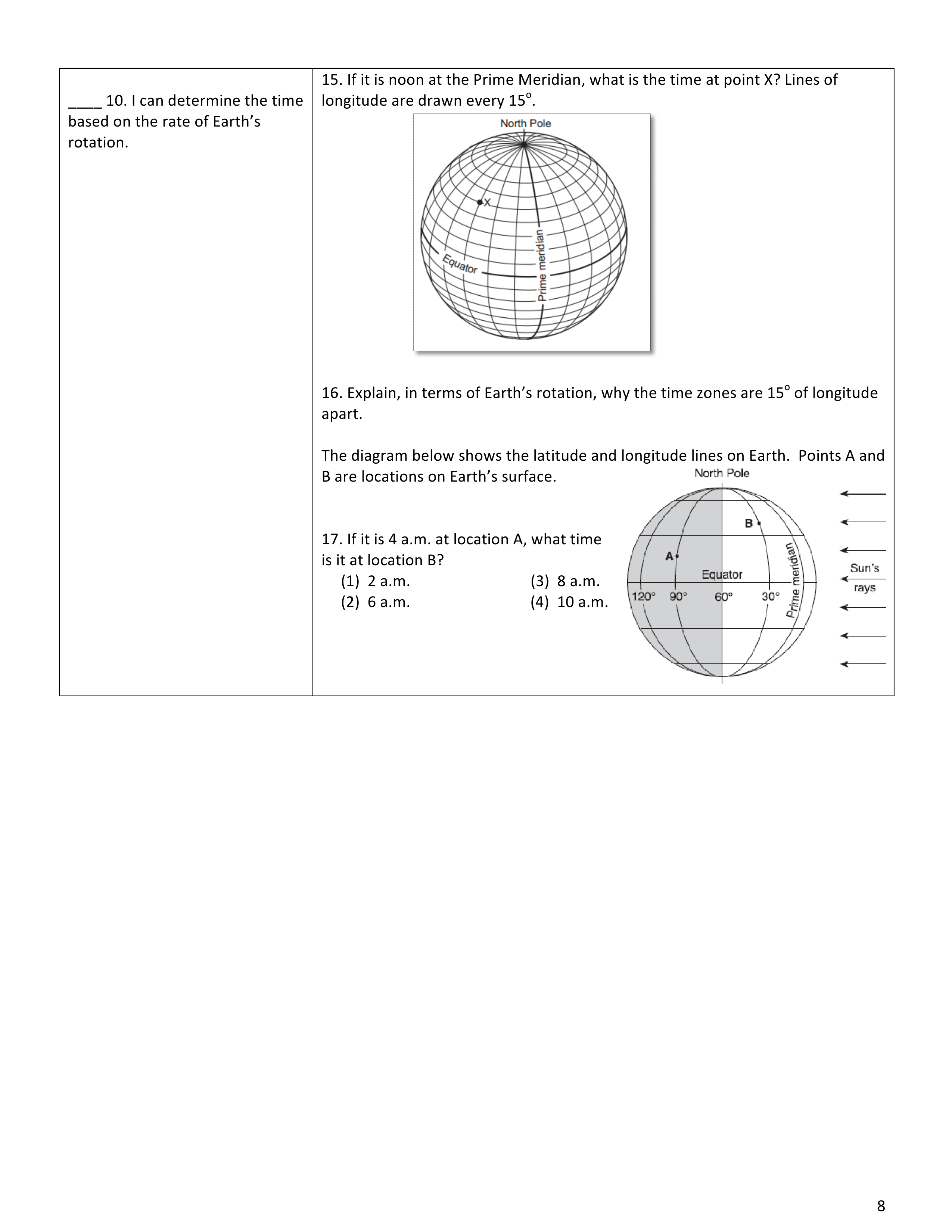
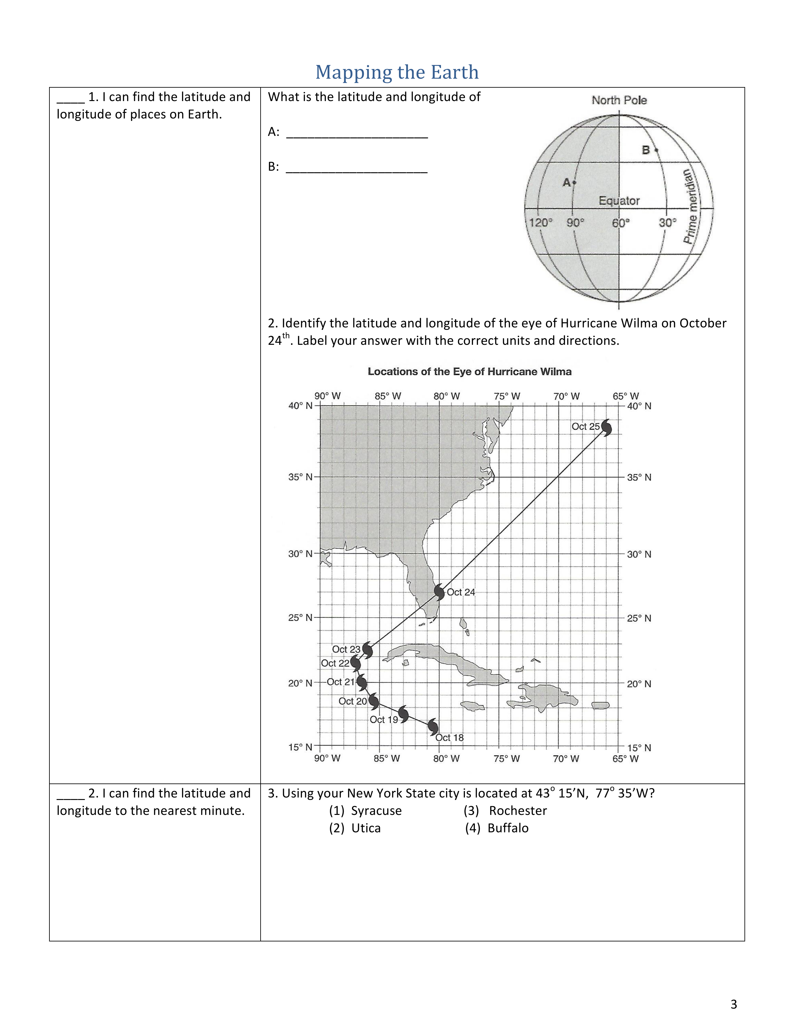
Latitude and Longitude: Imagine you are looking down on Earth from space, like an astronaut floating in orbit. You'll notice that Earth is divided into imaginary lines running horizontally and vertically. The horizontal lines are called lines of latitude, also known as parallels, while the vertical lines are called lines of longitude, or meridians.
Latitude measures distance north or south of the Equator, which is considered the starting point and has a latitude of 0 degrees. The lines of latitude are parallel to the Equator and are numbered from 0 degrees at the Equator to 90 degrees at the North and South Poles. Latitude is used to locate places on Earth's surface in a north-south direction.
Longitude, on the other hand, measures distance east or west of a line called the Prime Meridian, which runs through Greenwich, England. The Prime Meridian has a longitude of 0 degrees. The lines of longitude are perpendicular to the Equator and are numbered from 0 degrees at the Prime Meridian to 180 degrees east and 180 degrees west. Longitude helps us locate places on Earth's surface in an east-west direction.
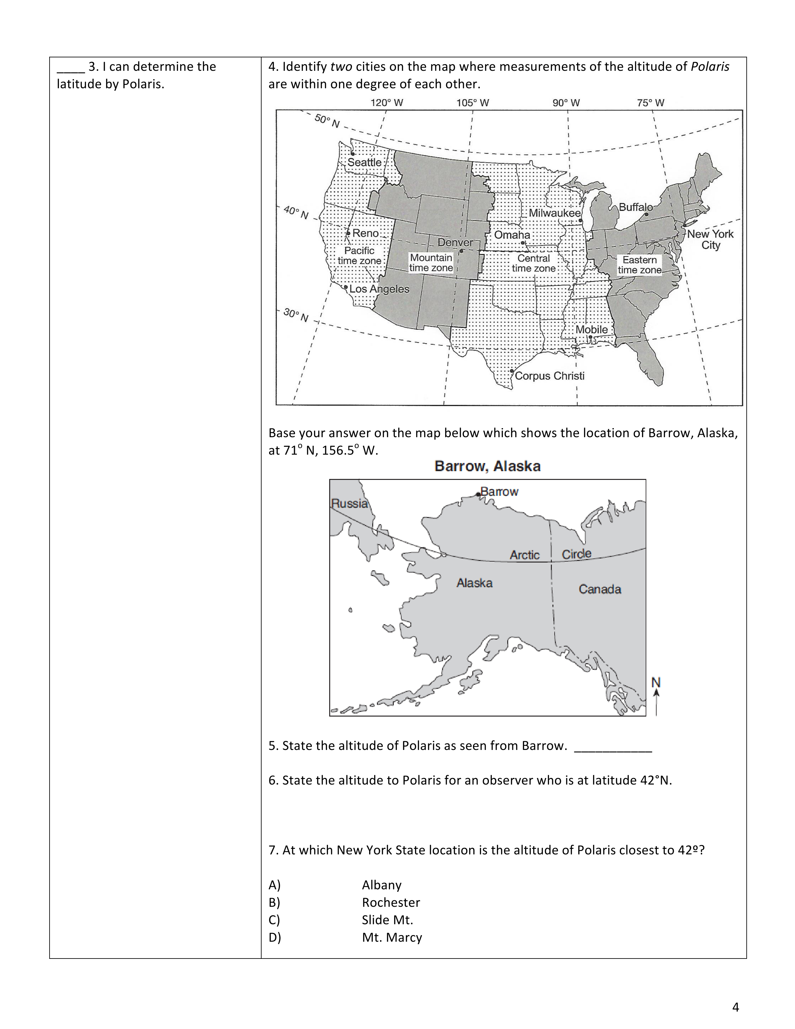
Altitude to Polaris: Polaris, also known as the North Star or Pole Star, is a bright star that appears almost directly above Earth's North Pole. When we look up at the night sky, Polaris seems to remain fixed while other stars appear to move as Earth rotates. Polaris is a crucial reference point for navigation and determining one's latitude in the northern hemisphere.
If you imagine standing on Earth's surface and extend an imaginary line upwards from your location, the angle between that line and the horizon is called the altitude. By measuring the altitude of Polaris above the horizon, we can estimate our latitude.
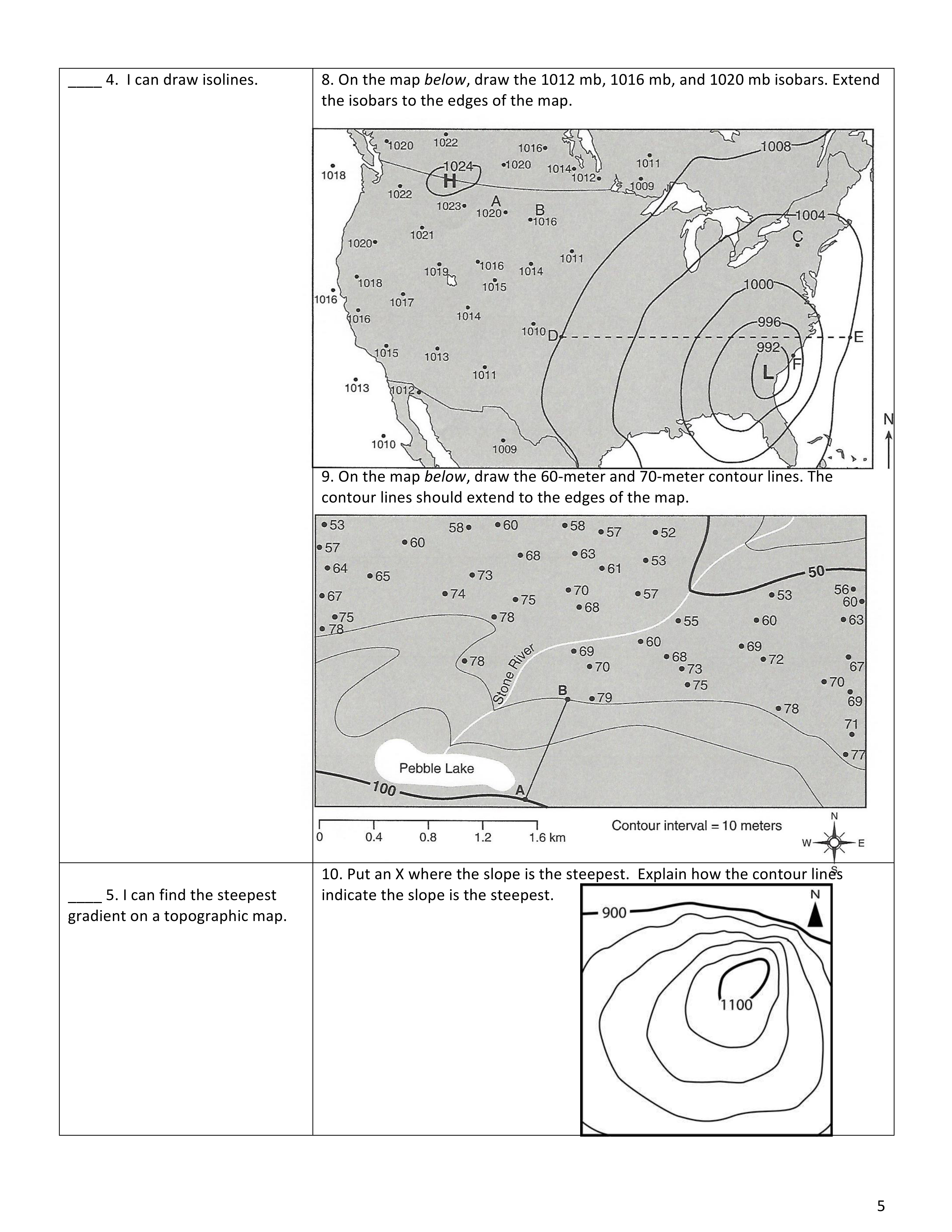
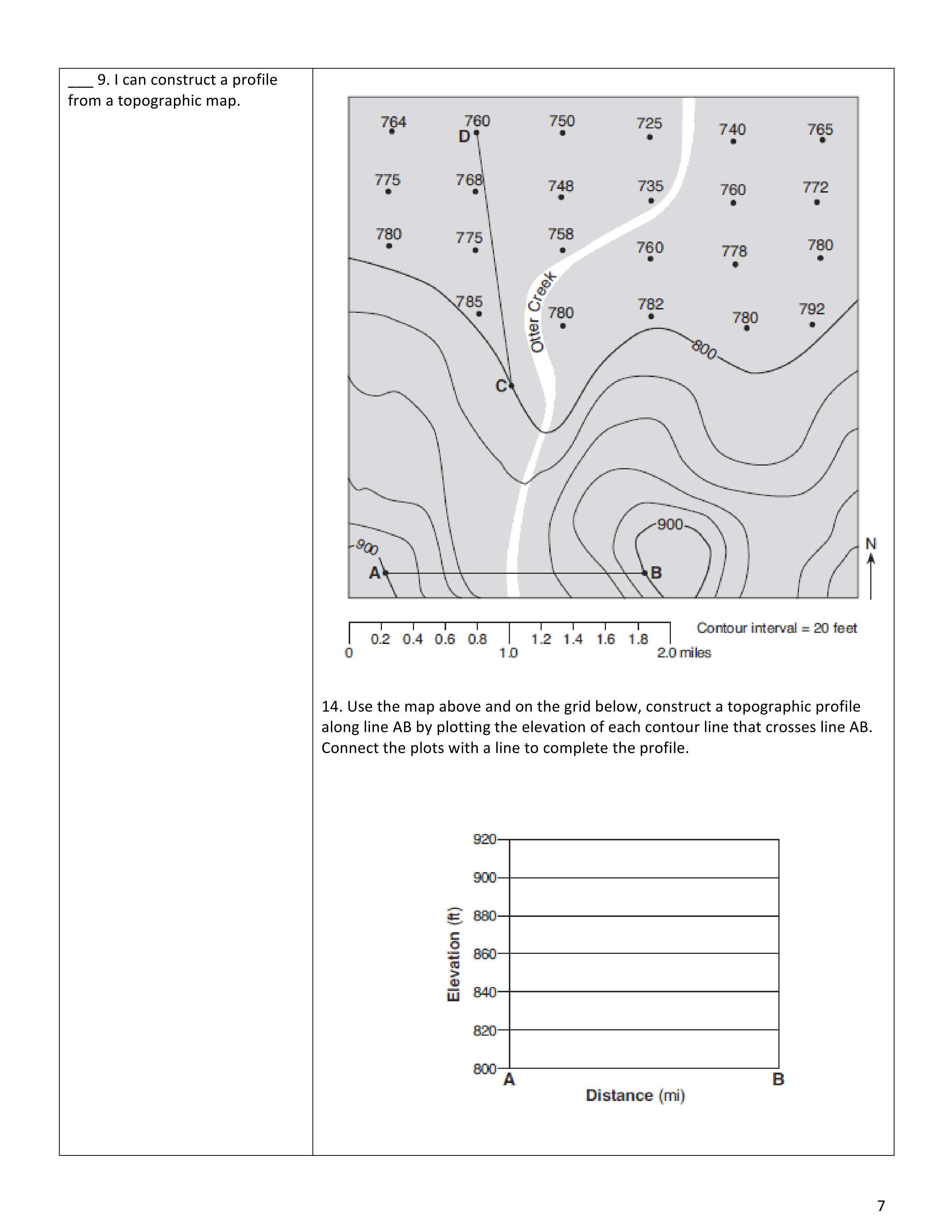
Topographic Maps: Topographic maps provide detailed information about Earth's surface features, such as mountains, valleys, rivers, and forests. These maps use contour lines to represent changes in elevation. Contour lines connect points of equal elevation, allowing us to visualize and understand the shape and steepness of the land.
Contour lines that are close together indicate a steep slope, while widely spaced lines represent gentle slopes. By studying topographic maps, scientists, hikers, and other explorers can plan their routes, identify potential hazards, and gain a better understanding of the terrain.
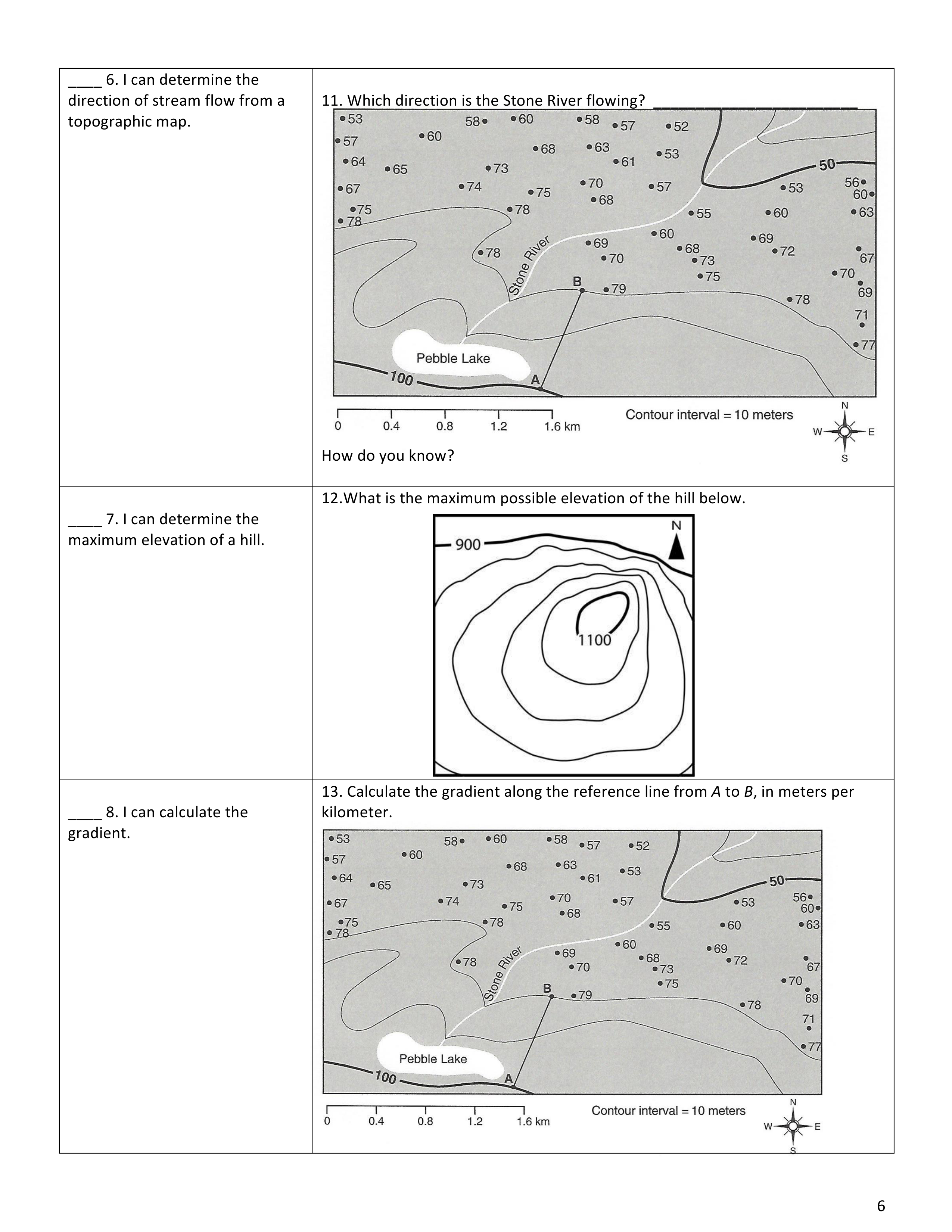
Gradient: The gradient refers to the steepness of a slope. In Earth Science, it is often calculated by dividing the change in elevation by the horizontal distance between two points. For example, if you hike up a mountain and gain 300 feet in elevation over a horizontal distance of 1,000 feet, the gradient would be 300/1,000, or 0.3.
Understanding gradients is crucial for various fields, including hydrology, geology, and engineering. It helps us assess the flow of water, predict landslides, and design structures that can withstand the forces exerted by steep slopes.
Stream Flow: Streams are an essential part of Earth's water cycle, carrying water from higher elevations to lower ones, eventually reaching the ocean. The flow of water in a stream is influenced by various factors, including the gradient of the land, the shape of the stream channel, and the amount of water available.
Scientists study stream flow to understand how water shapes the landscape, estimate water availability for human needs, and predict potential flooding. By measuring the speed, volume, and direction of stream flow, they can make informed decisions regarding water management and environmental conservation.
Conclusion: Mapping is an integral part of Earth Science, enabling us to explore and comprehend our planet's diverse features. Latitude and longitude help us pinpoint locations on Earth's surface, while altitude to Polaris aids in determining latitude in the northern hemisphere. Topographic maps provide valuable information about elevation and landforms, while gradients and stream flow assist in understanding the movement of water and the shaping of our landscapes. By mastering these concepts, we can better appreciate the intricate workings of our planet and make informed decisions for its sustainable future.