1:2 QUIZ Geographer's Tools
star
star
star
star
star
Last updated over 6 years ago
16 Nsɛmmisa
5
5
5
5
5
5
5
5
25
5
5
5

5
5
5
5
Method of collecting data and measurements of the surrounding land which is used to map out areas
Loss of accuracy in a map; a change in the shape, size, or position of a place when it is shown on a map.
Method of mapping the Earth's round surface onto a flat map.
What do you call a geographer who specializes in making maps?
Which of the following are weaknesses of globes? CHECK ALL CHOICES THAT APPLY
Why do all world maps have distortion?
An inaccuracy, or loss of accuracy in the shape, size, or position of a place when it is shown on a map is referred to as
Cartographers must gather information from several places to create a map. Check ALL of the sources from which a cartographer might gather this information.
CHECK ALL CHOICES THAT APPLY
Drag each map tool to its correct description.
Item 1

Item 2


Used to show where in the world the subject matter is located.
Used to calculate distance from one location to another.
Used to identify what various colors or symbols on a map represent.
Used to determine in which direction one would travel from one place to the next.
Used to determine the subject matter of a map.
A computer program that stores geographic data and produces different maps to show the data is called a:
Which of the following best represents a use for a GIS - Geographic Information system?
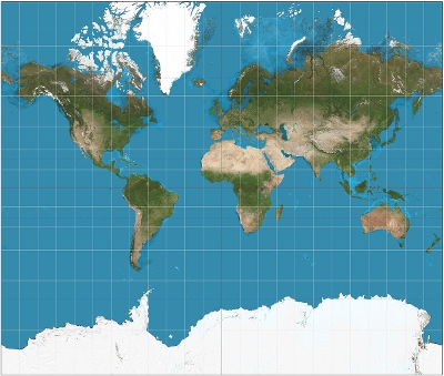
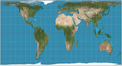
Identify the world map projection ABOVE this question.
Identify the world map projection ABOVE this question.
Identify the world map projection ABOVE this question.
Which is the most accurate representation of Earth's surface?
If you were taking a roadtrip with your family and your GPS stopped, would you stop at the nearest store to buy a map or a globe?
Provide 2 reasons why your choice would make the most sense.