Lesson 5 Extra Credit - What is Fog?
star
star
star
star
star
Last updated over 5 years ago
8 Nsɛmmisa
1
1
1
1
1
1
1
1
The scene can be as spectacular as a view from above showing only the tops of city skyscrapers poking through or as disorienting as a sheet of gray directly in front of you.
While common in some locations, fog can simply amaze us.
According to the Glossary of Meteorology from the American Meteorological Society, fog is a collection of water droplets suspended in the atmosphere in the vicinity of the earth's surface that affects visibility. Specifically, fog reduces visibility below 1 kilometer (or 0.62 miles).
Some Common Types of Fog
The most common form of fog, known as radiation fog, typically occurs on clear nights as the earth's surface cools moist air immediately above it. If just enough light wind is present – a couple of mph, at most – this chilled air can be gently stirred through a deeper layer, forming a deeper radiation fog.
Often in the fall, you'll see morning fog hug lower valleys of the Appalachians. This valley fog, really just a type of radiation fog, results from cold, dense air draining down mountain slopes at night, collecting in the valley floors, then forming as any other radiation fog described above.
Incidentally, let's dispel a myth. Fog does not burn off, per se.
As solar energy heats the ground near the fog's edge, vertical mixing brings drier air into the fog's edge, evaporating it. A typical ground fog will dissipate first at its edges, where its depth is more shallow, working its way toward the thicker center of the fog.
Sometimes fog forms when warm air moves over a cold surface. Warm air moving over snow-covered ground in winter and sea fog drawn inland over a cool land surface along the West Coast are two prime examples of so-called advection fog. Unlike radiation fog, advection fog can sometimes be seen as moving laterally along or near the ground.
When surface temperatures are below freezing, water droplets in a fog are supercooled, waiting to freeze on contact with any subfreezing surface. These freezing fog events can be dangerous not only for a reduction in visibility but also for a light accumulation of ice on roads, particularly bridges and overpasses.
At even colder temperatures, fog made up solely of tiny ice crystals will form. This ice fog is common in the winter months in parts of Alaska's interior, among other locations closer to the poles.
You may also notice steam fog from some lakes in the fall or early winter. Cold air overlaying warm air near the warm lake surface is an unstable configuration, lending itself to rising air. The mixing of cool air chills the warmer, more moist air immediately above the lake to allow condensation and a cloud to form. You can typically see wispy, vertical currents of fog rising from the lake.
Some other, less common fog types include:
Frontal fog: If warmer raindrops fall into colder, drier air, evaporation occurs. Eventually, the cold air moistens sufficiently to produce fog.
Upslope fog: Air moving gently upward in elevation enough for the layer to reach saturation, such as behind a winter cold front in the High Plains and Front Range of the Rockies.
Hail fog: On rare occasions, accumulated hail at the surface can chill the near-surface air enough to produce a shallow veil of fog.
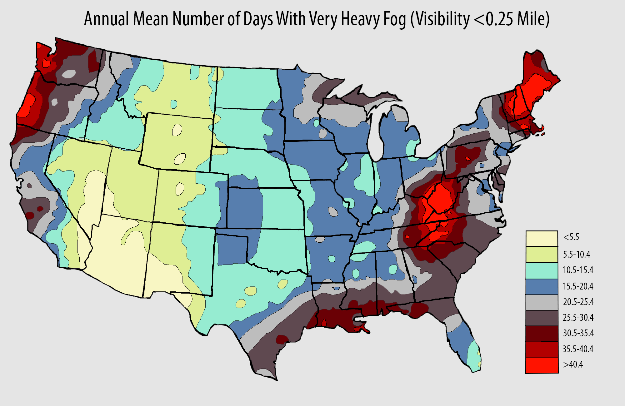
Average days per year with dense fog (defined as reducing visibility to one-quarter mile or less) in the U.S. Areas with most frequent fog are shown in darker gray, red shading.
Most Fog-Prone Areas
The Appalachians, parts of northern New England and the Pacific Northwest each typically see at least 40 days a year with dense fog (at least one-quarter mile visibility or lower). Of course, morning fog makes up the lion's share of these days, after which late-morning/afternoon sunshine is plentiful.
Parts of the northern Gulf Coast and California coast can also have frequent fog, if not always dense fog.
In winter, valley fog can hang stubbornly in lower elevations of the Great Basin, as well as California's Central Valley, as the combination of warmer air aloft moves over an area just soaked by the storm. Add an Arctic air mass spilling over the Continental Divide into the Great Basin, and this so-called "inversion" fog can hang in for days in places like Salt Lake City and Boise, trapping pollution near the ground, as well.
What about the least foggy location in the Lower 48 States? That would be the Desert Southwest, from southern Nevada and southwest Utah into Arizona and southwest New Mexico, averaging only a few days a year of dense fog.
Describe fog in your own words
What are the 2 things that are needed for radiation fog to occur?
How does valley fog form?
It has been really foggy overnight and into the mornings the last few days but the fog seems to burn off by the afternoon. Does fog really burn off or is something else happening?
What type of fog have we been experiencing the last few days? Can you explain how it formed?
Why does West Virginia have so much fog?
Why does the coast of Oregon experience a lot of fog?
Why does the coast of Louisiana experience so many days of fog?