Exploring Oregon's Climate (1)
star
star
star
star
star
Posljednje ažuriranje about 5 years ago
20
1
1
1
1
1
1

1
1
1
1
1
1
1
1
1
1
1
1
1
1
Learning Target #4 - I can explain and model causes of weather patterns and regional climates
Subtarget 4.4 - I can collect data to provide evidence for how the motions and complex interactions of air masses result in changes in weather conditions
Subtarget 4.5 - I can develop and use a model to describe how unequal heating and rotation of the Earth causes patterns of atmospheric and oceanic circulation that determine regional climates
PURPOSE: Make some observations about Oregon's regional climate patterns and construct a claim about the factors that might influence these patterns.
TASK #1
Throughout this unit, you will explore local weather systems as well as global and regional climate patterns. Perhaps more importantly, you will investigate the factors that shape these weather and climate patterns! In this lesson, you will briefly explore what weather and climate is all about. You will then spend some time thinking about the weather and climate patterns here in Oregon and the factors that might influence them!
Start by watching the short introduction to weather and climate below. Then answer questions #1-6.
What is weather?
What is climate?
Which of the following factors are involved in determining the local weather?
"Precipitation" refers to...
What was the weather like on Sabrina's first day in Yuma, Arizona?
By the end of her visit, what did Sabrina determine the climate is like in Yuma, Arizona?
The map above shows the average amount of precipitation received per year in different areas of Oregon over a 29 year time period. This map reflect's Oregon's...
On average, how much precipitation does the Portland metro area get each year?
In general, how much precipitation does the Oregon coast receive each year?
On average, how much precipitation does the city of Bend get each year?
As you look at the precipitation levels across the state of Oregon, what pattern do you notice as you move from west to east?
TASK #3
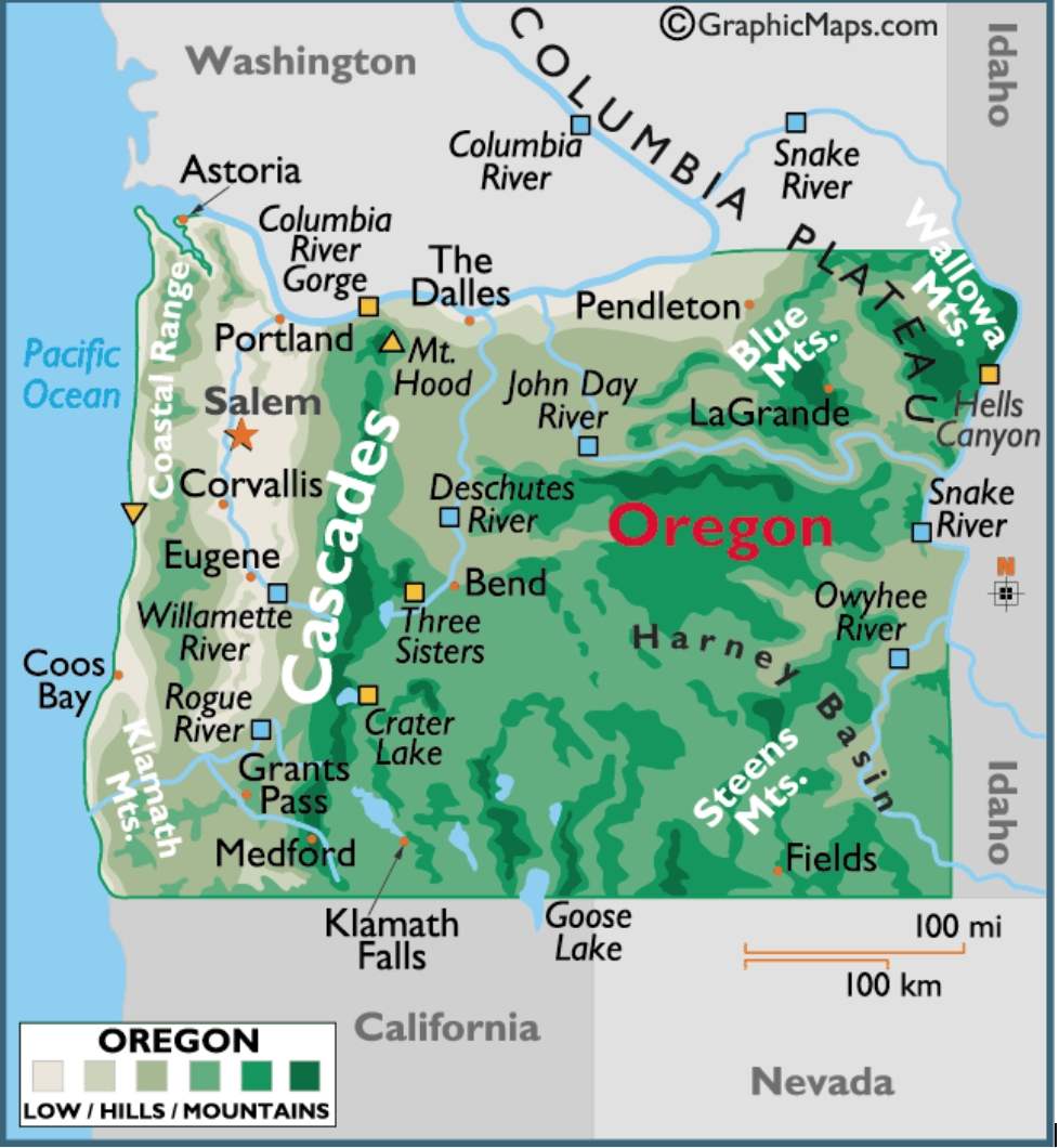
Elevation (or altitude) refers to a location's distance above sea level. Valleys are located at very low elevations, meaning they are very close to or below sea level. Mountains are some of the tallest points, meaning they have high elevations that reach far above sea level.
Take a minute or two to look over the geographical map of Oregon below. Then answer questions #12-18.
How would you describe the elevation in the Portland metro area?
How would you describe the elevation in Bend?
What elevation patterns do you notice as you move from west to east across the state of Oregon?
What mountain ranges do you see as you look at this map of Oregon? List them below.
How does the elevation of the Cascade Mountain Range compare to the Coastal Mountain Range?
Which of the following mountain ranges appears to be the longest?
What rivers, oceans, or other bodies of water do you see on this map? List them below.
TASK #4
As you can see from your analysis of the maps above, Oregon's climate is very different depending on which side of the state you live on. The Portland metro area is located in the Willamette Valley in western Oregon. It tends to be very rainy on this side of the state with fairly mild temperatures (meaning it never gets very hot or very cold). On the other hand, Bend and other cities in eastern Oregon are very dry throughout the year.
The question is...
Why is eastern Oregon so dry when it rains so much here in the Willamette Valley?
Construct a bullet-pointed CER outline to help you answer this question! Then use your outline to help you write your final CER paragraph on page 2 in your INB. Finally, you will upload a picture of your outline and your final paragraph to the "Show Your Work" spaces below.
Note: At this point in the unit, a CER is just your hypothesis! It is okay if your claim is not correct. You can pull evidence from any of the Oregon maps above. For the reasoning section, you can rely on either personal experience or prior knowledge you have of weather and climate concepts.
Click here to complete your CER outline! Then, take a screenshot of your outline and upload it to the "Show Your Work" section below.
Use the outline you created to write your CER final paragraph on page 2 in your INB. Take a picture of your final paragraph and upload it to the "Show Your Work" section below.
Click here to review the CER rubric before uploading your photo!