Log in
Sign up for FREE
arrow_back
Library

NJ Conservation Blueprint (Map/GIS Lesson)

star
star
star
star
star
Last updated over 1 year ago
18 questions
1
Question 1
1.

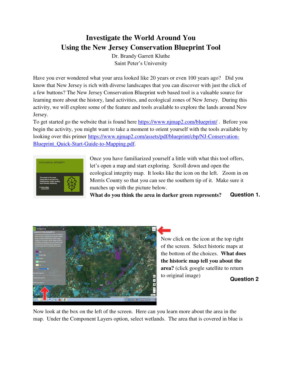
What do you think this area in Morris County in DARK GREEN represents?

1
Question 2
2.

In this Morris County area, what does the "Black and White 1930" map tell you about this area?

1
Question 3
3.

What are some of the important ECOLOGICAL FACTORS that WETLANDS provide?

1
Question 4
4.

In this Morris County area, what can you say about the circled purple area?

1
Question 5
5.

How many ACRES are in this parcel of land (the purple area in the Morris County area)

1
1
Question 7
7.

In this Monmouth County area back in 1930, how many acres are in the area you designated as undeveloped land?

1
1
1
1
1
1
0
Question 14
14.
1
Question 15
15.

What is the percent change of open space from 1930 to today?

1
2
2
Question 6
6.

In the Monmouth County area now, what are you seeing on the map now?

Question 8
8.

In this Monmouth County area, what DIFFERENCES do you see in the undeveloped land when you switch back to present day from 1930?

Question 9
9.

What ecological problems might that have?

Question 10
10.

How many open space plots did you create in present day of undeveloped land in this Monmouth County area?

Question 11
11.

Record the TOTAL amount of acres are found in your new plots of undeveloped land in present day in this Monmouth Co. area.

Question 12
12.

Let's recap. How many acres of open space did you designate in your original plot from 1930 map again?

Question 13
13.

What is the DIFFERENCE in acres between the current open space and the 1930 open space?

Question 16
16.

Can you list some examples of problems that might arise from a FRAGMENTED ecosystem?

Question 17
17.

1. Open up link of NJ Map under green box "Ecological Integrity": https://www.njmap2.com/blueprint/ecological/?override=1&zoom=8&lat=40.1474&lng=-74.88135009765627&sc=0&basemap=Google%20Satellite&layers=1417,283,202&ois=&oms=&po=
2. Search for "North Bergen High School" and zoom in on our area.
3. Explore and look around using the tool buttons.
*CAN YOU IDENTIFY ANY AREAS OF ECOLOGICAL CONCERN NEAR US? WHAT ARE THEY?

Question 18
18.

1. With the same map open, click on the upper right stack of maps icon and click on "Black and White 1930" of NBHS area.

*DESCRIBE THE CHANGES THAT YOU SEE AROUND US.

(Do not tell me you see houses back in 1930.. bc that's not a change.. we still have houses.... maybe look outside of NB area.)

(The bonus is optional and extra credit.)