Log in
Sign up for FREE
arrow_back
Library
Social Studies Work Station 1
By Taylor Merz
star
star
star
star
star
Share
share
Last updated over 4 years ago
8 questions
Add this activity
1
SS.5.7a
1
SS.5.7a
1
SS.5.6a
1
SS.5.7d
1
SS.5.7a
1
SS.5.6a
1
SS.5.6a
1
SS.5.7c
Question 1
1.
What is the purpose of a physical map?
A Physical maps show the borders of a country.
B Physical maps show special populations in certain regions.
C Physical maps show the land with its special charateristics and landforms.
D Physical maps help us show our own physical features and how we are similar to others.
Question 2
2.
What is the purpose of a political map?
A Political maps show regions and their political preferences
B Political maps show the boundaries and locations of countries, states, cities, towns and counties.
C Political maps show how poeple voted in past elections.
D Political maps will express the areas where people prefer to live.
Question 3
3.
A compass rose is not always needed on a map.
True
False
Question 4
4.
Which geographic formation would be found in the Western United States?
A The Gulf of Mexico
B The Rocky Mountains
C The Great Plains
D The Appalachian Mountains
Question 5
5.
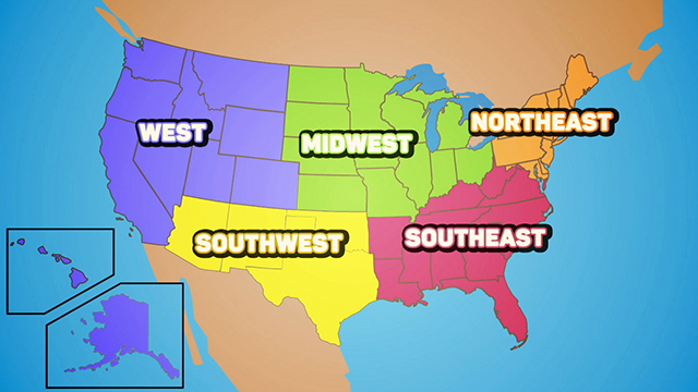
The above map is an example of a ________________________ map.
A Political
C Population
D Special purpose
Question 6
6.
Longitude and latitude lines make up a ______________ system for identifying specific locations of places.
Question 7
7.
Washington D.C. would be indicated on a map with which type of symbol?
Question 8
8.
Which region of the United States has the fewest states?
A Southwest region
B Southeast region
C Northeast region
D West region