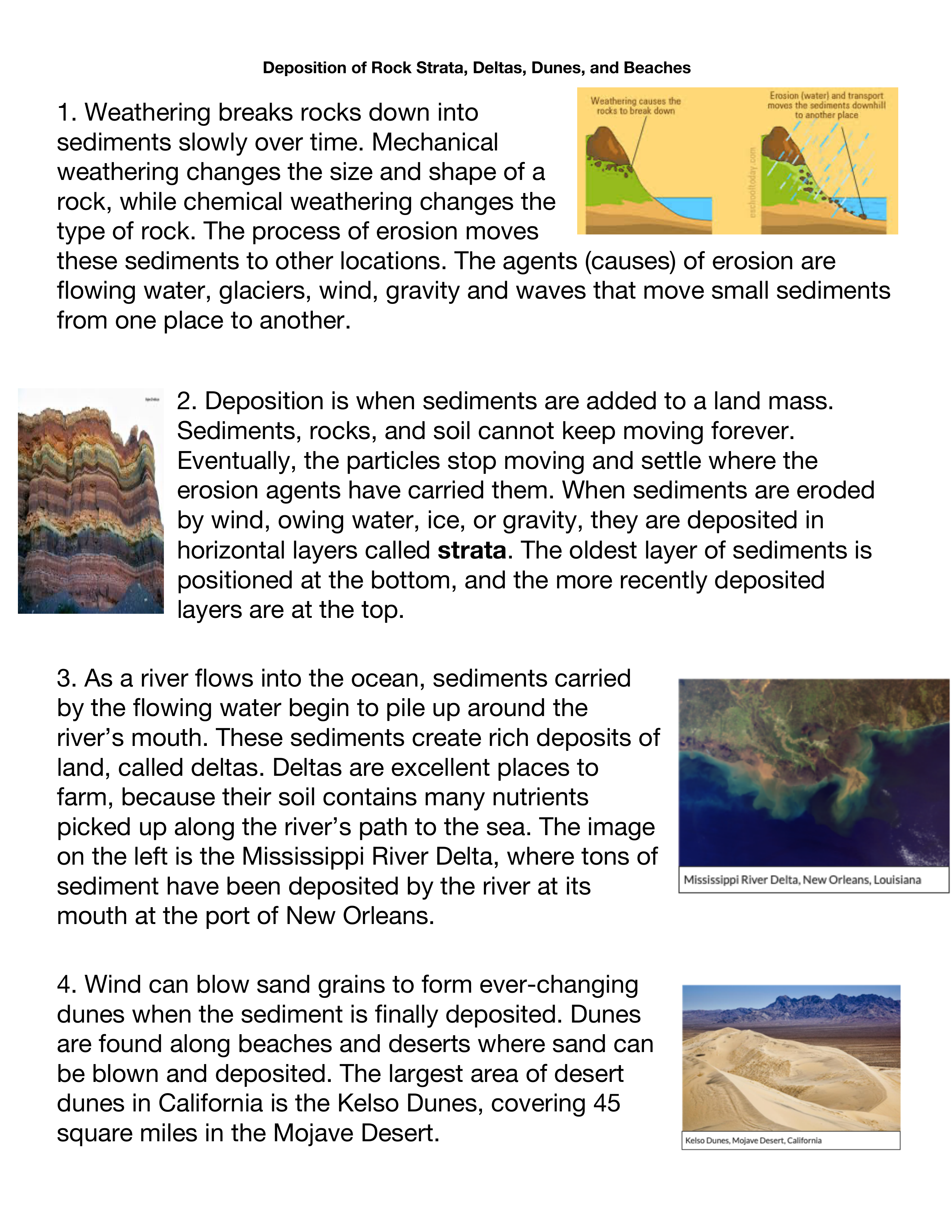
How was the Grand Canyon Formed?
star
star
star
star
star
Posljednje ažuriranje over 1 year ago
11
1
1
1
1
1
4

Weathering => land (breaking it up).
Erosion => land away.
Deposition=> to land (dropping land off).
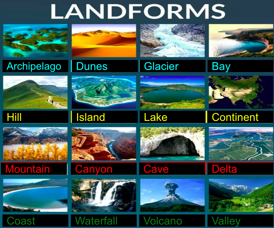
Categorize the following
Biosphere

Atmosphere

Hydropshere

Geosphere

Sphere that constitutes all of the water on the planet (in the ocean and on the surface of the earth)
Sphere that constitutes all of the gases surrounding the earth.
Sphere that constitutes all of the ecosystems making the earth.
Sphere that constitutes all of the soild earth
What does mechanical weathering change?
What does chemical weathering change?
What is the difference between erosion and weathering?
A) Deposition =
B) Years of erosion by water ice, and gravity will carry sediments where they are dropped off or
C) Deposited sediments may form layers called
D) Where are the oldest layers of the strata?
E) Which portrays an image of strata?
A) The Grand Canyon is ______ long, ______ wide, and _____ deep into the earth’s crust.
B) The Grand Canyon cannot be seen from space.
C) All the water in all the earth’s rivers would only fill the Grand Canyon
D) The Native American people called the area that of the canyon Kaibab meaning .
E) 1.8 billion years ago, the area that is known as the Grand Canyon was
F) Ancient oceans used to fill the area of the Grand Canyon, and the water used to rise and fall depositing sand, mud and seashells which was pressed together
G) If water ocean water used to rise and fall in the Canyon and "drop off" sediments slowly over time adding to the land, then what do we call this process?
H) The Colorado river was born ___ years ago by the…
I ) The Colorado river would push 500,000 tons of water through the canyon. This river water was mixed with sand and jagged rocks that...
J) When the Colorado river carried sand and jagged rocks and smashed it against the sides of the canyon, and then carried sediments away, this process is a combination of two things, ___________ (breaking of land) and ____________ (carrying land away)
K) What made the canyon so wide?
L) The Grand Canyon is still getting deeper and wider today.
After watching the video above, a few students were asked how the Grand Canyon was formed. Which student's answer is the most correct based on evidence from the video?
Have you ever wondered how the Grand Canyon was formed and why it is found here in Northern Arizona? To understand the formation of the canyon, there is a simple way to remember how it was shaped over time. All you have to remember are the letters D.U.D.E or dude. The letters stand for: Deposition, Uplift, Down cutting and Erosion.
The story begins almost two billion years ago with the formation of the igneous and metamorphic rocks of the inner gorge. Above these old rocks lie layer upon layer of sedimentary rock, each telling a unique part of the environmental history of the Grand Canyon region. Then, between 70 and 30 million years ago, through the action of plate tectonics, the whole region was uplifted, resulting in the high and relatively flat Colorado Plateau.Finally, beginning just 5-6 million years ago, the Colorado River began to carve its way downward. Further erosion by tributary streams led to the canyon’s widening. Still today these forces of nature are at work slowly deepening and widening the Grand Canyon.
Rock deposition
The story of how Grand Canyon came to be begins with the formation of the layers and layers of rock that the canyon winds through. The story begins about 2 billion years ago when igneous and metamorphic rocks were formed. Then, layer upon layer of sedimentary rocks were laid on top of these basement rocks. To look at rock layers, geologists use a diagram called a stratigraphic column. It shows the rock layers with the oldest on the bottom, and the youngest on the top. That means that the bottom layer was formed first, and every subsequent layer was formed later, with the youngest rocks on the top. In geology, this is referred to as the principle of superposition, meaning rocks on the top are generally younger than rocks below them. Another important principle is the principle of original horizontality. This means that all the rock layers were laid horizontally. If rock layers appear tilted, that is due to some geologic event that occurred after the rocks were originally deposited.
The Kaibab Limestone, the uppermost layer of rock at Grand Canyon, was formed at the bottom of the ocean. Yet today, at the top of the Colorado Plateau, the Kaibab Limestone is found at elevations up to 9,000 feet. How did these sea floor rocks attain such high elevations? Uplift of the Colorado Plateau was a key step in the eventual formation of Grand Canyon. The action of plate tectonics lifted the rocks high and flat, creating a plateau through which the Colorado River could cut down. The way in which the uplift of the Colorado Plateau occurred is puzzling. With uplift, geologists generally expect to see deformation of rocks. The rocks that comprise the Rocky Mountains, for example, were dramatically crunched and deformed during their uplift. On the Colorado Plateau, the rocks weren’t altered significantly; they were instead lifted high and flat. Just how and why uplift occurred this way is under investigation. While scientists don’t know exactly how the uplift of the Colorado Plateau occurred, a few hypotheses have been proposed. The two currently favored hypotheses call for something called shallow-angle subduction or continued uplift through isostacy.
The Colorado River has been carving away rock for the past five to six million years. Remember, the oldest rocks in Grand Canyon are 1.8 billion years old. The canyon is much younger than the rocks through which it winds. Even the youngest rock layer, the Kaibab Formation, is 270 million years old, many years older than the canyon itself. Geologists call the process of canyon formation downcutting. Downcutting occurs as a river carves out a canyon or valley, cutting down into the earth and eroding away rock. Downcutting happens during flooding. When large amounts of water are moved through a river channel, large rocks and boulders are carried too. These rocks act like chisels, chipping off pieces of the riverbed as they bounce along. Several factors increase the amount of downcutting that happens in Grand Canyon: the Colorado River has a steep slope, a large volume, and flows through an arid climate.
Weathering and erosion are ongoing processes. If we were to visit Grand Canyon in another couple million years, how might it look? For one, it would be wider; we may not even be able to see across it anymore. Much of Grand Canyon’s width has been gained through the erosive action of water flowing down into the Colorado River via tributaries. As long as water from snow melt and rain continues to flow in these side drainages, erosion will continue. In a few million years, Grand Canyon also may be a bit deeper, though the canyon isn’t getting deeper nearly as fast as it is getting wider. The rocks through which the river is currently downcutting are hard, crystalline igneous and metamorphic rocks, which are much stronger than the sedimentary rocks resting above them. More importantly, the river’s gradient has decreased, such that it has less power to battle with the hard rocks. Finally, the river’s elevation near Phantom Ranch, a popular hiking destination in the canyon, is just 2,400 feet above sea level. Because sea level (0 ft.) is the ultimate base level for all rivers and streams, upon reaching sea level, the Colorado River will be done downcutting.
Source:https://www.nps.gov/grca/learn/nature/grca-geology.htm#:~:text=Uplift%20of%20the%20Colorado%20Plateau,Colorado%20Plateau%20occurred%20is%20puzzling.
IN YOUR OWN WORDS!!! Explain what weathering and erosion is, and how weathering and erosion are involved in the making of the Grand Canyon. I recommend you watch the video again from 2.38-3.12s and 3.24-3.40s
Word bank: weathering gravity subtracting land breaks down builds up sediments Colorado river ice wind rain freeze erosion transport downstream
Landscapes are more difficult to date than rock formations. Still, by looking at relationships between rock formations, scientists are able to determine ages of landscapes with some precision. Scientists have used this type of relative dating technique to narrow the age of the Colorado River and Grand Canyon. Scientists know that the Colorado River carved Grand Canyon. The river is thus slightly older than the canyon, though the two are certainly close in age. Scientists have studied rock deposits along course of the present day Colorado River. By looking at the type of sediments the deposits contain, scientists determine whether or not the rocks were deposited by the river. Rocks deposited by the river are younger than the river, as the river needed to be around to deposit them. Rocks not deposited by the river are older than the river because the river was not yet there to drop them. When possible the scientists then date these rock deposits. The age of the river falls between the rocks determined to be older than the river and those determined to be younger. Through this method, scientists have estimated an age for the river, and thus the canyon through which it flows, of 5-6 million years.
It is fairly easy to explain the formation of Grand Canyon through downcutting, weathering, and erosion. It is more difficult to explain just how the Colorado River came to be in its current location. We can think of the development of the Colorado River as a history book with many chapters. The most recent chapter is familiar, because it is the chapter that is visible today. But, there are a number of chapters missing. The plotlines of some of those missing chapters are heavily debated. There are a few chapters in the story that the majority of geologists agree upon. For one, evidence collected thus far suggests that the upper and lower reaches of the Colorado River are different ages. The lower section in California, Nevada, and Arizona is younger than the upper portion in Utah and Colorado. The age of the younger portion of the river is estimated to be between 5 and 6 million years based on the various constraints listed in the Ages section. The older portion, or “ancestral Colorado River,” is at least 7 million years old and may even be 10 million years old, based on the presence of river gravels found near Grand Junction, Colorado. When the upper and lower portions combined, an event called drainage integration, the Colorado River became what it is today. In other words, the river that we know today as the Colorado River, was actually once either two different rivers that have been joined together or a much shorter river that was later lengthened. Another widely accepted chapter in the Colorado River’s history book is that the landscape of the Colorado Plateau and surrounding areas looked very different at the time that the Colorado River developed. We know younger rocks once rested on top of the Kaibab Limestone because of land forms such as Red Butte south of Grand Canyon, which is composed of some of these younger rock layers. The majority of these rock layers, however, have been eroded away. We can only guess what the landscape might have looked like, but it is likely that this unknown topography influenced the present course of the river. Today, the Kaibab Plateau, a high point through which the river gingerly slices, poses a problem for geologists. Water certainly doesn’t flow up hill, so geologists hypothesize that at the time the river started cutting through it, the Kaibab Plateau must not have been an obstacle. It may have been smaller 10 to 30 million years ago, or perhaps it was buried beneath layers of flat-lying Mesozoic rocks, only to be revealed after the river had already established its course. While keeping these few accepted chapters in the Colorado River’s history book in mind, geologists have proposed a number of different hypotheses to explain how the river became a through-flowing river with an outlet at the Gulf of California. As we learn more, some hypotheses may be confirmed or proven false. Regardless, it is safe to say that geologists won’t ever know all of the answers! There is still much to be learned about the Colorado River and Grand Canyon. As more research is completed, we will continue to learn.
A) Delta's are terrible places to farm because they are jagged and rough, as well as hard to get to .
B) Sediments being carried away by a river is an example of . Sediments that pile up around the rivers mouth and add land mass is called .
How are dunes formed?
