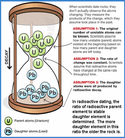
Using the resources provided, explain in your own words how we can use radiometric dating to figure out exactly how old rocks are.
Magnetism Review:
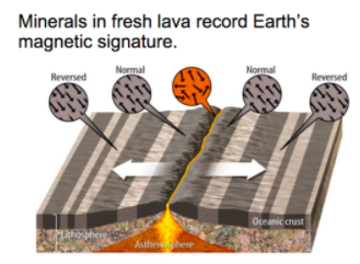
Earth’s magnetic poles have switched places repeatedly in the past. As you can see in the figure, each time the switch occurred, Earth’s magnetic field was reversed. The magnetic field is the region around a magnet over which it exerts magnetic force. We think of today’s magnetic field direction as “normal,” but that’s only because it’s what we’re used to.
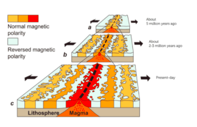
Scientists don’t know for certain why magnetic reversals occur, but there is hard evidence that they have for hundreds of millions of years. The evidence comes from rocks on the ocean floor. Look at the images to the right. They show the same ridge on the ocean floor during different periods of time.
A. At the center of the ridge, hot magma pushes up through the crust and hardens into rock. Once the magma hardens, the alignment of magnetic domains in the rock is frozen in place forever. Magnetic domains are regions in the rocks where all the atoms are lined up and pointing toward Earth’s north magnetic pole.
B. The newly hardened rock is gradually pushed away from the ridge in both directions as more magma erupts and newer rock forms. The alignment of magnetic domains in this new rock is in the opposite direction, showing that a magnetic reversal has occurred.
C. A magnetic reversal occurs again. It is frozen in rock to document the change.
Rock samples from many places on the ocean floor show that the north and south magnetic poles reversed hundreds of times over the last 330 million years. The last reversal was less than a million years ago.
Plates at a mid ocean ridge are moving
In your own words, explain how new rocks are formed at mid ocean ridges.
In your own words, explain how magnetism can tell us the relative ages of rocks.
Just over a century ago, in 1915, a young German scientist named Alfred Wegener, published his theory of continental drift in Die Entstehung der Kontinente und Ozeane (in German, The Origin of Continents and Oceans). This theory stemmed from a simple, but astonishing observation of a world map: the coastlines of South America and Africa seemed to fit together like the pieces of a puzzle. To Wegener, this suggested that the continents had once been part of one supercontinent, but had somehow broken and drifted apart. Motivated by this observation, Wegener went digging for more information. Luckily for him, it didn't take long before he found fossil, rock, and climate data that also supported his idea of a supercontinent. After putting all this information together, he formally developed his theory of continental drift. Unfortunately, Wegener couldn't explain how continents moved, so he wasn't taken seriously by the geologists of his time. He died never knowing that his theory was eventually accepted and supported (explained) by the theory of plate tectonics. Now that we know a little more about Wegener and his theory, let's look through the evidence that both supports and explains his theory of continental drift.
CLICK ON THE PICTURE TO MAKE IT BIGGER

PLANT FOSSILS
The European flora (pink) is a group of plants that lived about 300 million years ago (MYA).
The Glossopteris plant (green) was a fern-like plant with large, heavy seeds that wouldn't have been carried far by wind or water.
ANIMAL FOSSILS
The Cynognathus reptile (blue) lived about 230 MYA, and was approximately 10 feet long (3 meters). It was a weak swimmer that lived primarily on land.
The Lystrosaurus reptile (purple) lived around the same time as the Cynognathus, and were also poor swimmers who lived on land.
The Mesosaurus reptile (blue-green) lived about 250 MYA. This reptile was about 1.5 feet long (0.5 meters) and lived on both land and in fresh-water (rivers and lakes).
If you were given the following diagram of our continents and fossil information (below the image), and then asked to explain it, what would you say? How would you rearrange the continents?
CLIMATE EVIDENCE
Large sections of South America, Africa, India, Australia, and Antarctica all have similar glacial striation patterns left in the rock. In order for this to happen, the contents we have today must have once been joined together close to the poles (as opposed to near the equator where some of them are now). Similarly, sections of North America, South America, Africa, Europe, and Asia show evidence that they were once tropical environments (i.e., near the equator). A strong piece of evidence for this is the discovery of coal swamps, which form in warm, tropical areas that are teaming with plant life. Additional discoveries of coral reefs and salt deposits suggest the same.

In your own words, explain how we can use historical climate evidence to support the theory of continental drift.
Which of the following pieces of evidence support the claim that there used to be one big continent on Earth? Select all that apply.
Which of the following can tell us the actual ages of rocks?
Which of the following can tell us the relative ages of rocks?