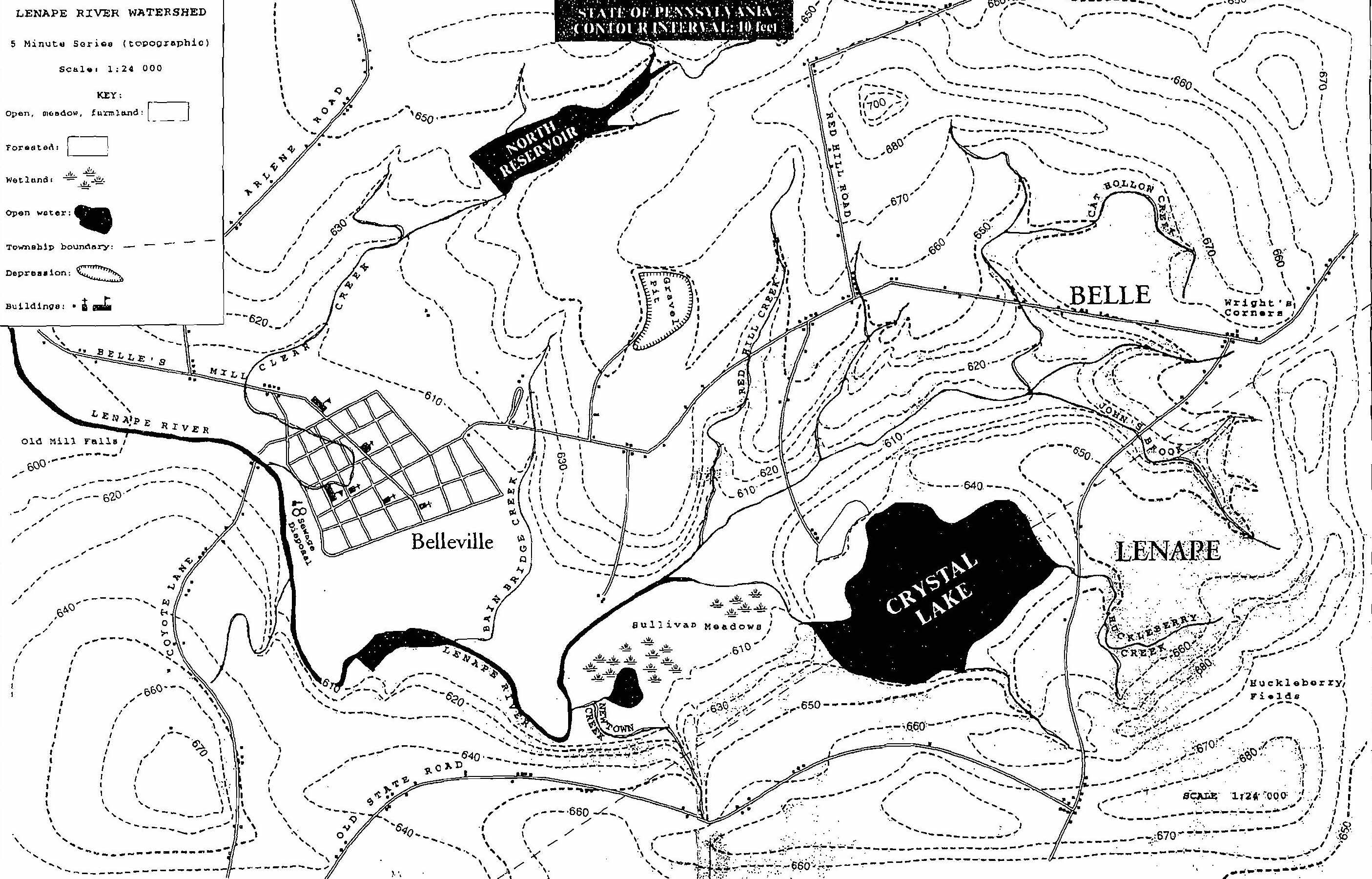
What is the contour interval of the map?
Name a stream that flows into Crystal Lake and the name of the river that begins at Crystal Lake.
What is the elevation of the gravel pit?
What is the name of the meadow just west of Crystal Lake?
Follow the procedure below to determine watershed boundaries:
a) divide Lenape River or one of its tributaries into at least 5 sections of equal length
b) at each division, draw a line at right angles to the stream bed c) to establish the boundaries of the watershed, follow each line you drew upslope, away from the stream bed, until the elevation is at a maximum (use contour line readings). Mark this for both sides of the stream.
d) put a point at the highest elevation above the headwaters also e) now connect each of these "ridge" points to outline the boundaries of the watershed.
Where does the surface runoff go that falls within the watershed? (i.e. what body of water does runoff go into?)
What happens to surface runoff that falls outside the watershed? (generally speaking)
Is the slope of the land uniform throughout the watershed area? If not, how would you describe the topography that is with the boundaries of the Lenape River watershed?
What is the highest elevation in the watershed (in feet above sea level?) Where is it located?
What is the lowest elevation in the watershed? Where is it located? Give a reason for your answers.
Where is the Lenape River’s velocity likely to be the greatest? Where is the river’s velocity likely to be the slowest? (Hint: look at the contour lines to help you answer the questions.) Give a reason for your answers.
How can you determine the direction that the Lenape River flows? (Hint: find a contour line that crosses the river and which way the “v” formed by the lines is pointing. Water travels down slopes.)
What land use activities result in the highest contamination from the following AND what specific problems are introduced (i.e., nitrogen, phosphorus, low D.O., turbidity, etc.) Be specific. You should not have the same answers for all 3.
Fertilizer?
Sediment?
Human waste?
What portion of the river is MOST vulnerable to flooding? Why? (Hint: use elevation as the key factor in determining your answer.) What is the best way to prevent damage and loss of life from flooding?
How do you think all of the above can affect the water quality within the watershed?
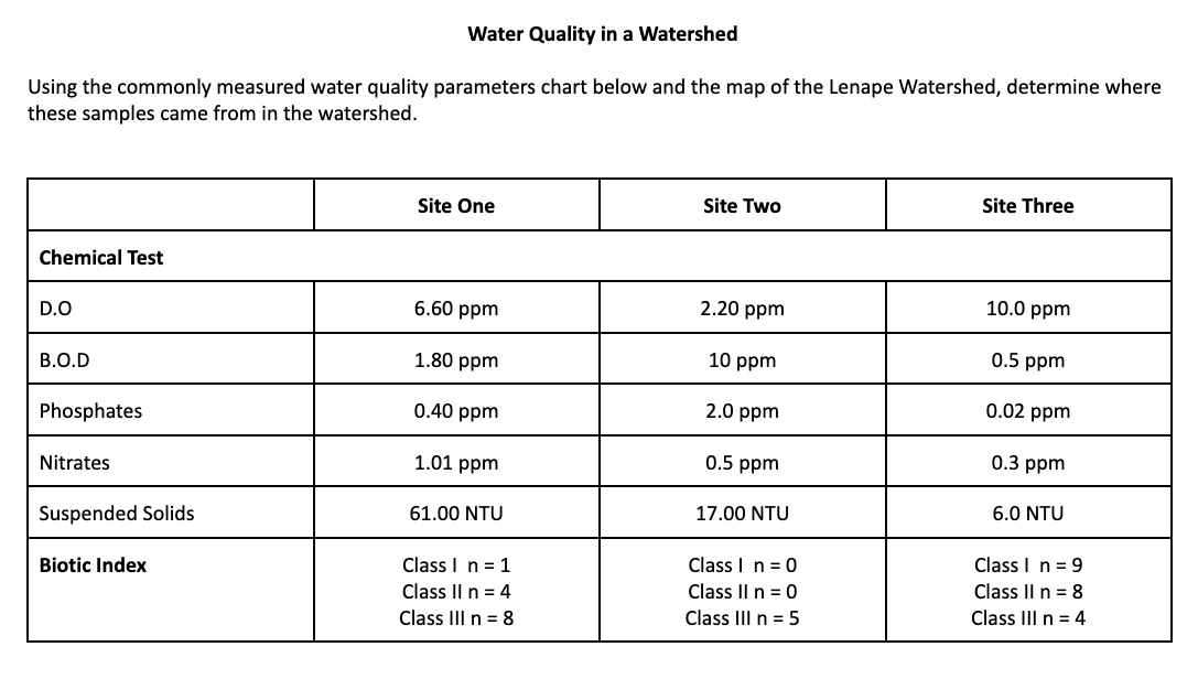
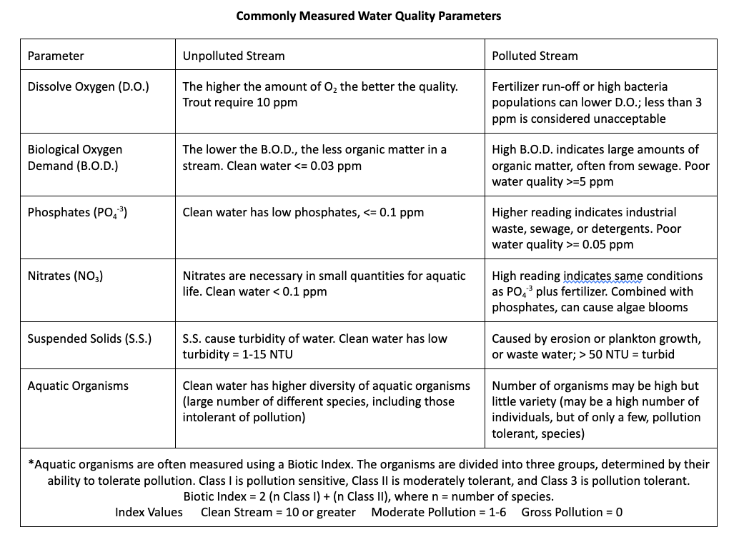
WATER QUALITY IN A WATERSHED: PART III (USE THE “WATER QUALITY IN A WATERSHED” CHART)
Use the criteria from the “Water Quality in a Watershed” chart above to determine where sites 1, 2 and 3 are located on the map. Clearly label those locations as SITE 1, SITE 2, SITE 3 on the map. For each, EXPLAIN below why you chose those sites (include in your answer any human activities or lack of activities nearby that might influence the chemicals present in the water at each site.)
Site 1:
Site 2:
Site 3:
Where in the Lenape River Watershed would you prefer to live (describe using nearby land features, roadways, water quality considerations)? Give TWO reasons for your choice.