Copy of Rain shadow Effect Learning (6/12/2024)

Last updated over 1 year ago
19 questions
Note from the author:
What is the rain shadow effect? What Earth Systems interact to cause the rain shadow effect? Use videos, websites, graphs and images to learn about it. At the end, be ready to explain the steps that cause the rain shadow effect and explain how different earth systems interact because of the rain shadow effect.

What is a Rain Shadow Effect?

By the end of this lesson, you will be able to explain the rain shadow effect using a diagram. Watch the next video.

1

What makes a cloud? Rewatch the video if you need to, she just said it:)

Watch this video to start your learning.

Go to the website and visit Mt. Hood in the state of Oregon. This mountain is in the Cascade Mountain range in the Pacific Northwest.
Fly over Mt. Hood in this video. Carefully observe the landscape on each side of the mountain.
https://lsintspl3.wgbh.org/en-us/lesson/buac20-il-mountainshadow/?as_guest=True&next=https://rmpbs.pbslearningmedia.org/resource/buac20-68-sci-ess-mountainshadow-il/mountains-and-rain-shadows-interactive-lesson/
1

What do you observe that is different from one side of the mountain to the other?

1

Which side of Mount Hood gets more precipitation (rain or snow)?

1

How do you know that side of the Mountain gets more precipitation? Support your answer with evidence from the images or the video.

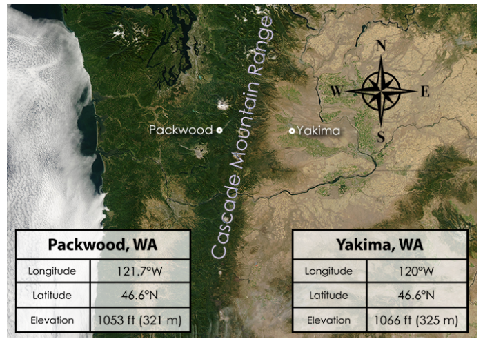
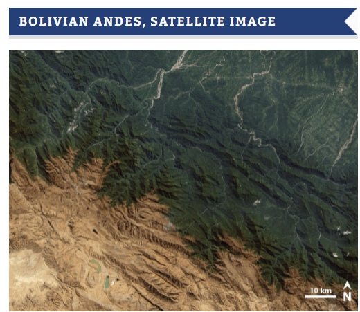
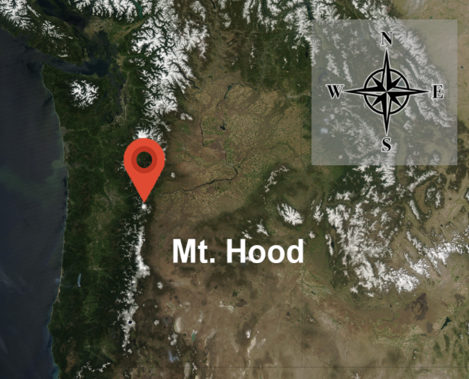
This image was taken from a satellite that is looking down on the Cascade Mountain Range and Mount Hood from above.
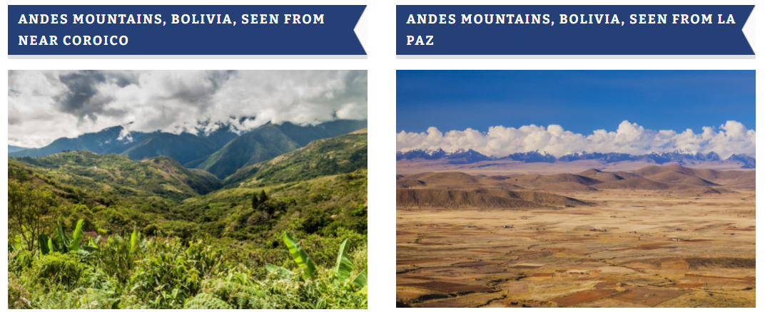
This picture is in natural color, which means that it shows the colors of the region similar to how they appear in the real world. The colors can provide clues as to what the climate might be like (on either side of the mountain range).
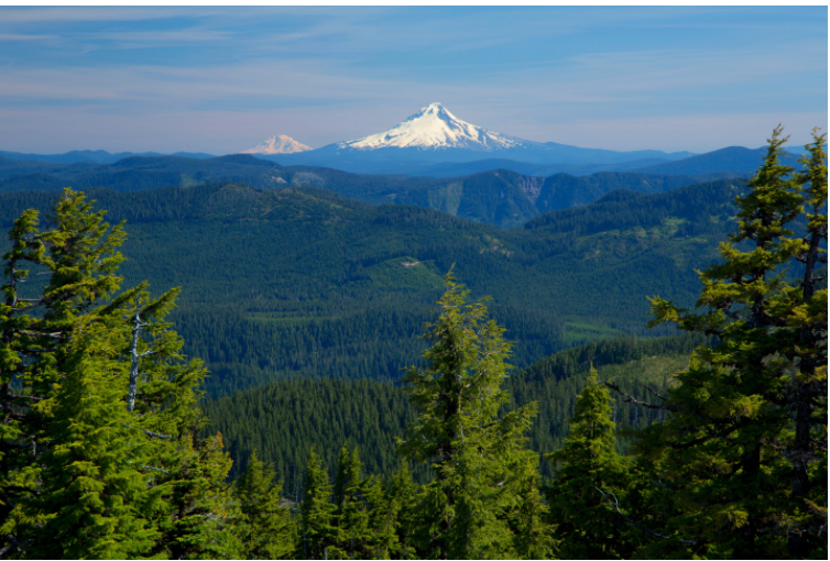
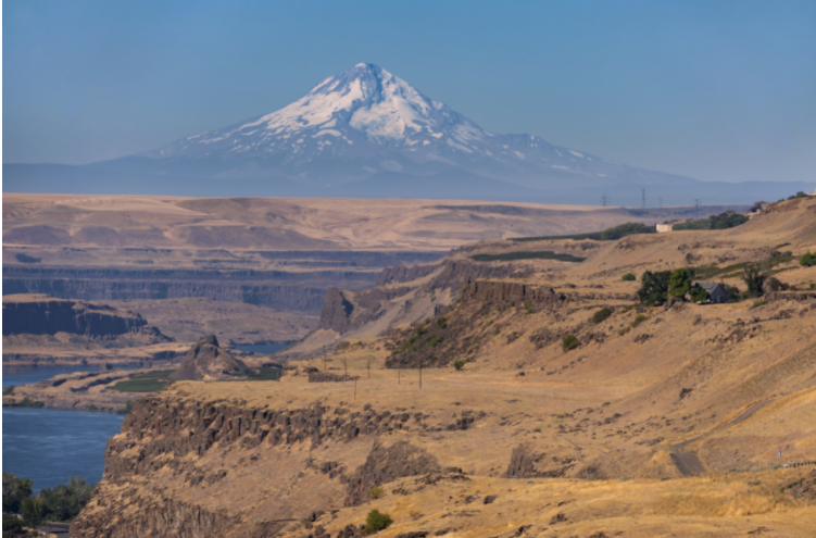
Use this image and the next to answer question #5.
1

Using the pictures above: Looking at the location of Mt. Hood on the satellite image, which side of Mt. Hood were the two pictures above taken from?

How different can climate conditions be on either side of a mountain? Let’s look at the data for two towns that are on either side of the Cascade Mountain Range.
Packwood is a town on the west side of the Cascade Mountains in the state of Washington in the Pacific Northwest region of the United States. At a similar elevation and latitude on the east side is Yakima, WA. The distance between Packwood and Yakima is about 55 miles.
The bar graphs below show the mean monthly temperature and precipitation over the course of one year for Packwood and Yakima.
2

Explain the difference in temperature between the two towns. Use evidence from the picture or from the graphs to support your answer.

2

Explain the difference in precipitation (rain) between the two towns. Use evidence from the picture or from the graphs to support your answer.

1

What is the wettest month in Packwood? Use the graph key(on the right of the graph) to know to look at the orange or the blue line .

All around the world there are mountain ranges that have a region that is much drier on one side—like the mountain range shown in this diagram.  What causes this to happen?
To understand how a mountain range affects the climate nearby, first think about where the moisture in the atmosphere comes from.
When wind blows over the ocean or other source of water, the air picks up water vapor as water evaporates from the surface of the body of water.
In this way, the wind carries off moisture as it moves away from the body of water.
To understand how a mountain range affects the climate nearby, first think about where the moisture in the atmosphere comes from.
Play the video to see what happens when water from the ocean evaporates into the atmosphere, a process that can be observed by satellite.


Click this link and watch the video on the website: https://lsintspl3.wgbh.org/en-us/lesson/buac20-il-mountainshadow/7
Large-scale winds that blow predominantly in the same general direction over a particular region during a given period of time are called prevailing winds. These winds can carry water vapor a long distance from water sources.
In some places these prevailing winds encounter a landform, like the mountain range in this illustration.
The side of the mountain range facing the prevailing wind is called the windward side. The side facing away from the prevailing wind is the leeward side.
As air carrying moisture moves toward a mountain range, the slope of the mountain range forces the air upward.
The diagram on the left illustrates how the air pressure higher up in the atmosphere is lower because fewer molecules push down from above. Therefore, as the moisture-filled air rises, it expands as the air pressure decreases. As the molecules in the air move further apart, they lose energy and slow down, which lowers the temperature.
Temperature typically decreases about 5.5°F for every 1,000 feet of altitude gained. For example, if this mountain peak is 8,000 feet, the temperature at the peak would be 44°F cooler than at the bottom of the mountain!
The air continues to cool as it it rises. As the air cools, it can hold less water vapor. Eventually, the air cools enough so that water molecules start to condense and form tiny droplets. These droplets are visible as clouds.
Play the video to see how clouds form.
https://lsintspl3.wgbh.org/en-us/lesson/buac20-il-mountainshadow/10
Eventually, the droplets become large enough that gravity causes them to fall to Earth as rain, sleet or snow.
1

Predict what the moisture content of the air will be by the time the air arrives on the other side of the mountain range. In other words, how much rain will be left in the cloud as it moves to the other side?

With most of its moisture removed due to precipitation, the air now passes over the summit of the mountain range and begins to descend on the other side.
At lower levels in the atmosphere, the air pressure is greater because more molecules in the air press down from above.
As the air descends, the molecules that make up air are forced closer together and rapidly gain energy, increasing the temperature. The air—by now very dry—becomes warmer as it continues to move down the mountain range.
1

True or False: When air encounters a mountain and rises up its slope, the temperature decreases.

1

True or False: When air encounters a mountain and rises up its slope, precipitation decreases.

1

The air moving up and over the mountain results in:

The lack of
moisture and of rain on the leeward side of a mountain range results in a "rain shadow"—a patch of land that is very warm and dry. Many deserts around the world result from the rain shadow effect
Another example of a rain shadow effect. This mountain is in the Andes Mountains in Bolivia in South America. Look at the satelite image of the same place below.
1

What happens where the 1 is? Feel free to refer back to refresh your memory.

1

What happens where the 2 is? Feel free to refer back to refresh your memory.

1

What happens where the 3 is? Feel free to refer back to refresh your memory.

1

What happens where the 4 is? Feel free to refer back to refresh your memory.

1

How are the geosphere(what part of the diagram is the geosphere?) and the hydrosphere interacting with one another to create the rain shadow effect? The geosphere effects the hydrosphere to create the rain shadow effect by ____________.

1

How does the hydrosphere effect the biosphere (life or death) due to the rain shadow effect? Think of the plants, what is happening due to the hydrosphere? The hydrosphere, during the rain shadow, effects the biosphere by _____________.

1

How are the atmosphere and the hydrosphere interacting with one another to create the rain shadow effect? Think of wind, temperature, low/high pressure, etc During the rain shadow effect, the atmosphere and hydrosphere interact by_________.