Homework: Air fronts and Air masses

Last updated 9 months ago
11 questions
4
Warm front symbol
__________
Cold front symbol
__________
Stationary front
__________
Occluded front
__________
5


Warm fronts occur when we have a warm air mass _______ and replacing a cold body of air, covering the cold air from the top and forcing the cold air out below. This type of front moves rather _______ (typically 10 to 15 miles per hour). Generally warm fronts have high _______ and because the air is moved upward by the frontal change you will see stratiform and cirri type of clouds and some fog can be expected along the way.

In summer months this lifting action can trigger cumulonimbus clouds to rain. Precipitation will be _______ to moderate & will be accompanied by poor visibility. During the passage of the front, stratiform clouds are also visible - you may see some _______ . After the passage of the front visibility will improve but hazy conditions might exist for a short period of time after.
4
Word Bank:
surface

Cold fronts at the __________ force warmer air upward. Cold fronts are __________ and generally move at 20 to 30 miles per hour (but some cases report 60 miles per hour speeds). This quick movement of warmer air upwards is causing the creation of clouds. Depending on the stability of the warmer air mass, cloud types are going to change. Typically these clouds are going to be either towering, cumulous, or cirrus types clouds. However, we may see some cumulonimbus clouds as well. Depending on the intensity of the cold front, cumulonimbus clouds can result in __________.

After the frontal passage, towering cumulonimbus clouds will begin to dissipate and the precipitation will also decreases. In some cases, where a fast moving cold front is present, a squall lime will form. Squall lines are __________ that form ahead of the cold fronts. They are very intense and can move very quickly.
1

Compare and contrast cold vs. warm fronts.

  • Brings clouds close to the base of the ground (low ceilings)
  • Approach with very little warning
  • Poor visibility and rain
  • Changes the weather completely in a few hours
  • Occurs more slowly
  • Weather clears rapidly after the front passes
  • Provides a warning of the coming front
  • The weather that does occur is more intense
  • Are generally less intense
  • Warm front
  • Cold front
3
Word Bank:
equal
mix
period

Stationary fronts are going to occur when the forces of 2 air masses are mostly _______. A stationary front can sit over an area for a relatively long _______ of time.

The weather conditions associated with a stationary front are generally a _______ of cold and warm air front conditions.
5

Occluded fronts occur when we have a _______ moving cold front that catches up to a _______ moving warm front.

Cold Front Occlusion

The cold fronts air mass is colder than the warm front's air mass. The cold air mass is going to _______ the warmer air and create a mixture of weather that we find in both of these frontal passages.

Warm Occlusion

The warm fronts colder air mass is colder than the cold front's air mass. When this occurs the cold front is going to ride up and travel up _______ the warm front's cold air mass.

Generally a warm occlusions weather is going to be more _______ than a cold occlusion with a bit of thunderstorms, rain, and fog.

Air Mass

A large body of air that has a similar temperature and water content or humidity throughout is called an air mass. Air masses have similar temperature and moisture/dryness. When different air masses meet it causes the weather to change.
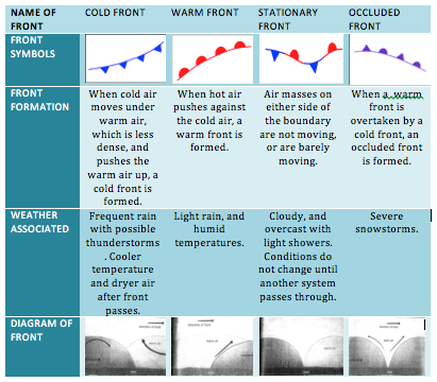
Fronts

When two different air masses collide a front forms. Typically this is the boundary between cold and warm air masses.

Weather

Weather fronts appear as different colored lines that extend outward from the pressure center. They mark the boundary where two opposite air masses meet.

Warm fronts are indicated by curved red lines with red semicircles.
  • Light rain and humid temperatures
Cold fronts are curved blue lines with blue triangles.
  • likely to produce thunderstorms
  • violent storms generally form

Stationary fronts have alternating sections of red curves with semicircles and blue curves with triangles.
  • Neither air mass that meets is stronger, so it doesn't move
  • it can stay over one area for a long time

Occluded fronts are curved purple lines with both semicircles and triangles. Weather fronts are found only on surface weather maps.


14
A large body of air that has relatively uniform temperature and humidity __________

What is an air mass?
__________

An air mass has similar __________

The boundary between cold and warm air masses is called a __________.

What type of front is represented in this picture below? __________

What type of front is represented in this image? __________

Which front is likely to produce thunderstorms? __________

Violent storms generally form along __________?

Light rain and humid temperatures?__________

Which front is there little movement? __________

Stationary fronts can bring a lot of precipitation because __________

The warm front is moving North in the image. I can tell because: __________

Which type of front is displayed? __________

Which type of front is displayed? __________
4
6


An air mass is a large mass of air in which temperature and _______ are the same throughout. For example, the air mass over Alaska is cold and dry. The air mass over Florida is warm and moist.

For an air mass to form, the air must stay over the area long enough to pick up the _______ of the area.

Most air masses will form over cold areas called polar _______ or warm tropical areas. In addition, you will find air masses that form over oceans and will be very _______ .

Air masses that form over the ocean are called _______. Air masses that form over land and continents are dry and are called _______ air masses. Remember an air mass is a large mass of air in which temperature and humidity are the same throughout.
6
A) Maritime tropical are formed over water and are __________

B) Maritime equatorial air masses are formed over the equatorial oceans__________ and are found that the equator.

C) Maritime polar air masses are formed over polar oceans and are __________ and they form over the northern atlantic and northern pacific ocean.

D) Continental tropical air masses are __________. They are formed over land that is above and below the equator.

E) Continental polar air masses are __________ and are formed over land at the poles.

F) Continental arctic/antarctic air masses are __________ that is formed over land in the arctic/antarctic regions.
3

Maritime air masses form over _______ & continental air masses form over _______ . The areas humidity may change with the weather.

So what causes the air mass to move? Global _______ and jet steams help move these air masses.

Cold air masses move toward the equator and warm air masses move toward the poles.