Obavezno
1
Obavezno
1
Obavezno
1
Obavezno
1
Obavezno
1
Obavezno
1
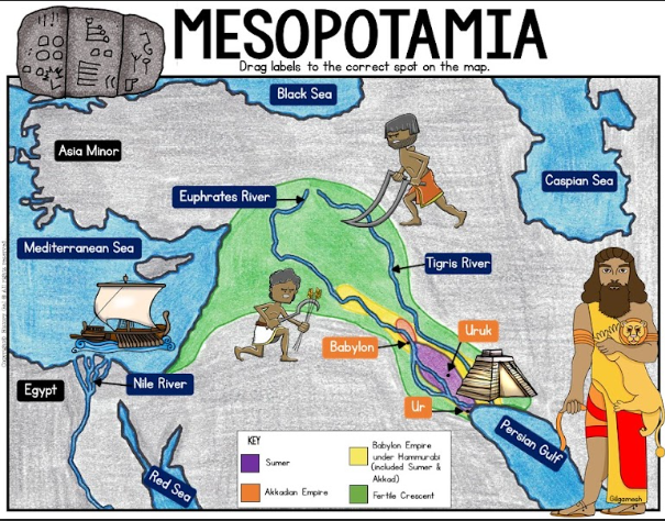
Mesopotamia is a Greek word meaning 'between the rivers'. The rivers are the Tigris and Euphrates which flow through modern Iraq. The Euphrates also flows through much of Syria. Mesopotamia is made up of different regions, each with its own geography. The geography of each area and the natural resources found there affected the ways that people lived
What does Mesopotamia mean?
What are the two rivers located in this region?
Northern Mesopotamia is made up of hills and plains. The land is quite fertile due to seasonal rains, and the rivers and streams flowing from the mountains. Early settlers farmed the land and used timber, metals and stone from the mountains nearby.
What is the land like in this region?
What causes fertile land?
Southern Mesopotamia is made up of marshy areas and wide, flat, dry plains. Cities developed along the rivers which flow through the region. Early settlers had to irrigate the land along the banks of the rivers in order for their crops to grow. Since they did not have many natural resources, contact with neighboring lands was important.
Where did cities develop in this region?
How did early settlers adapt to their land to allow crops to grow?
Follow the directions on the slide.
The Fertile Crescent surrounded which rivers?
What civilizations were located in the Fertile Crescent?
Babylon and Ur were located next to which river?
The Tigris and Euphrates Rivers flow into what larger body of water?
What river flows into the Mediterranean Sea?
Why did early civilizations begin near rivers?