Describe how wind patterns and the Coriolis effect drive surface ocean currents
Analyze maps and diagrams to explain how ocean gyres form and why garbage patches collect in the center of these circular currents.
Identify that winds push surface currents in the same direction, describe that currents rotate clockwise in the Northern Hemisphere and counterclockwise in the Southern Hemisphere, and explain the Coriolis effect causes this rotation.
Locate the five major garbage patches on a map and explain why garbage collects there.
If you need help with this assignment, please click here to watch the class recording.
Describe how wind patterns and the Coriolis effect drive surface ocean currents
Analyze maps and diagrams to explain how ocean gyres form and why garbage patches collect in the center of these circular currents.
Identify that winds push surface currents in the same direction, describe that currents rotate clockwise in the Northern Hemisphere and counterclockwise in the Southern Hemisphere, and explain the Coriolis effect causes this rotation.
Locate the five major garbage patches on a map and explain why garbage collects there.
If you need help with this assignment, please click here to watch the class recording.
Geography Review
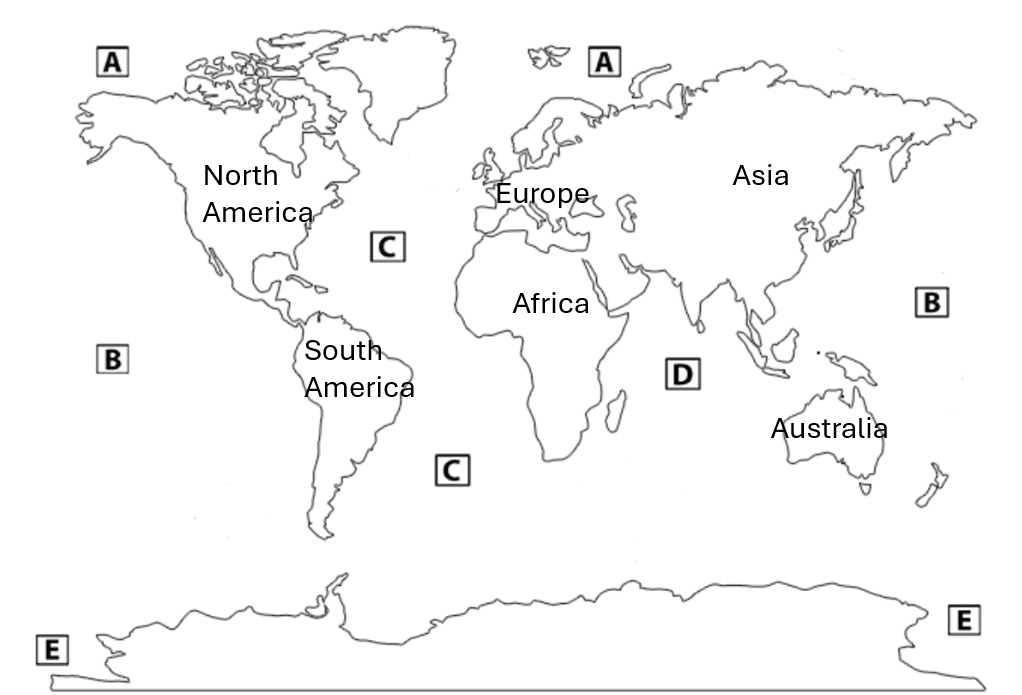
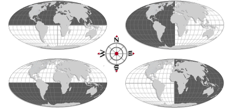
A hemisphere is half of Earth. An imaginary line divides Earth into two equal halves:
The Equator splits Earth into the Northern Hemisphere (above the Equator) and the Southern Hemisphere (below the Equator).
An imaginary line through the poles (the Prime Meridian and the 180th meridian) splits Earth into the Eastern Hemisphere (east of the Prime Meridian) and the Western Hemisphere (west of the Prime Meridian).
Label the hemispheres highlighted in the image below.
Geography Review
Names & locations of the world's oceans
Pacific Ocean: Largest; stretches between the Americas (east) and Asia/Australia (west).
Atlantic Ocean: Between the Americas (west) and Europe/Africa (east); connects north and south via the equator.
Indian Ocean: South of Asia, between Africa (west) and Australia (east).
Southern (or Antarctic) Ocean: Encircles Antarctica; southernmost ocean surrounding the continent.
Arctic Ocean: Smallest; located around the North Pole, bordered by northern North America, Greenland, and Eurasia.
Label the oceans on the map. You will use each label 2 times (except 1) to account for how oceans span wide regions.


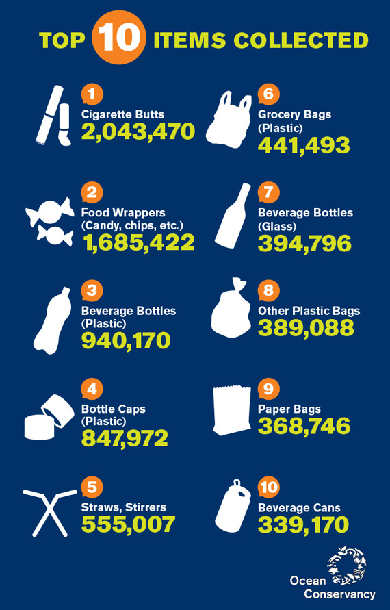
The infographic shows the top 10 items collected during ocean clean-up events.
Which category would most of these items fall under?
Thinking Question: How could trash from one part of the world end up on the other side of the Earth?
Will plastic released from different areas of the same continent end up in the same place(s)?
Go to the Plastic Adrift website to test various locations or watch the videos below.
Consider plastic being released from Peru on the west coast of South America:
Then consider plastic being released from the same continent, but now at the southern tip of Chile:
Did plastic released from different areas of the same continent end up in the same place(s)?
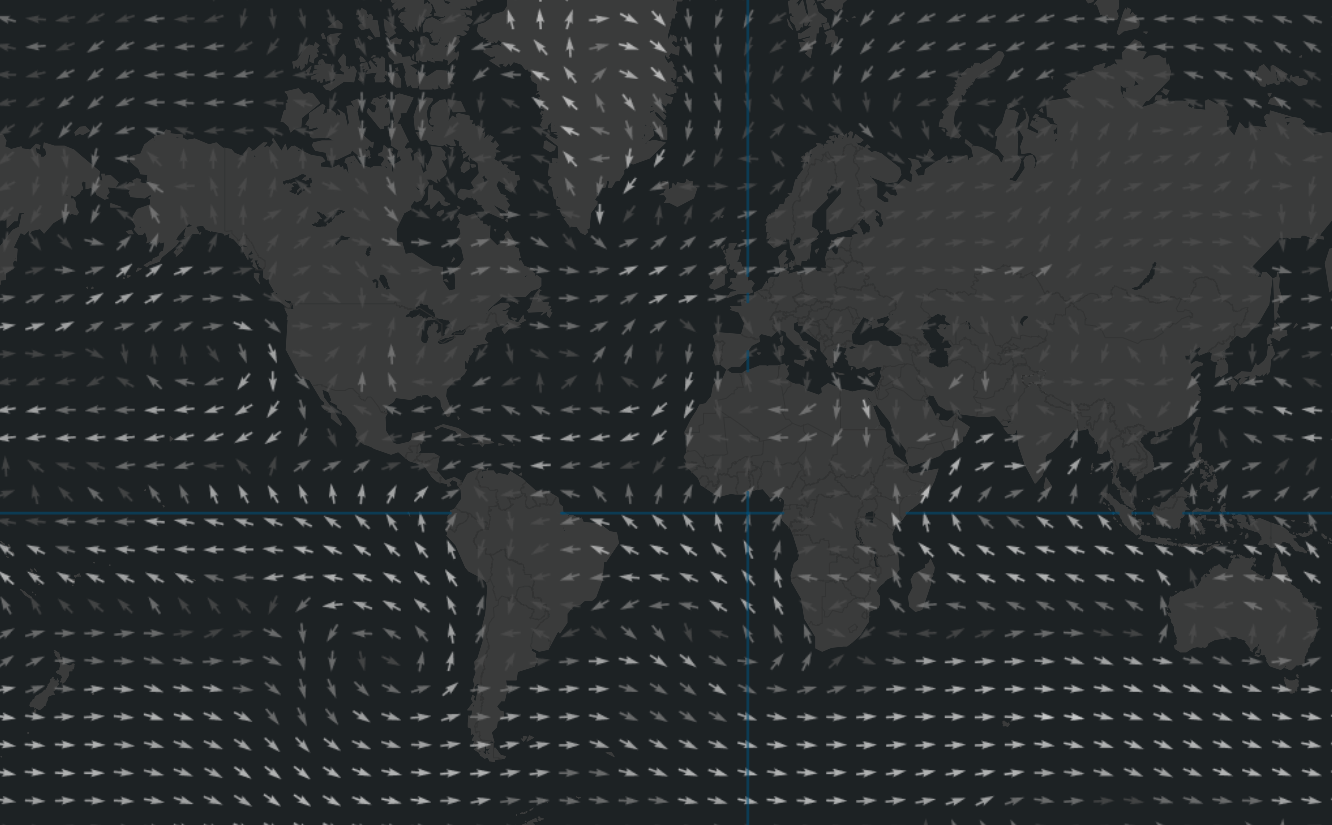
On the map you are viewing average wind speed and direction near the ocean surface. The direction of the arrow represents the direction of the winds, while the color of the arrow represents wind speed (black representing 1 meter per second, gray 10 m/s, and white 20 m/s).
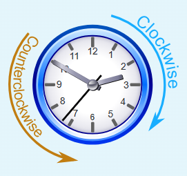
For each point on the map, indicate whether the winds around it rotate clockwise or counterclockwise.


Why do winds move clockwise or counterclockwise? What forces could be acting on the wind?
The Coriolis Effect makes moving air appear to because Earth is .
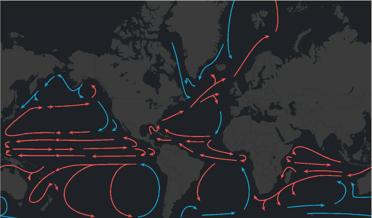
On the map you are viewing current temperature and direction near the ocean surface. The direction of the arrow represents the direction of the current. Red represents warm currents, blue represents cold currents.
For each point on the map, indicate whether the currents around it rotate clockwise or counterclockwise.


What conclusion can you form about ocean winds and surface currents?
Winds push on the surface of the ocean, so currents move in the direction as the wind.
Winds and surface currents move clockwise in the and counterclockwise in the .
Garbage Patches are large areas of ocean where litter and other marine debris collect. You can think of them as large whirlpools that pull debris into one location, forming what we call "patches".
Thinking Question: Based on what you have learned about winds and surface currents, which areas or regions of the ocean are garbage patches likely to form? Why?
In a scientific study, NASA tracked the movement of buoys released by NOAA over the last 35 to study how litter and debris travels to garbage patches. They discovered, that by tracking buoys released in the ocean, they could see patterns in where the buoys drifted.
Watch this video to learn about the results of this garbage patch visualization experiment:
Did you correctly predict most of the garbage patches in the previous question?

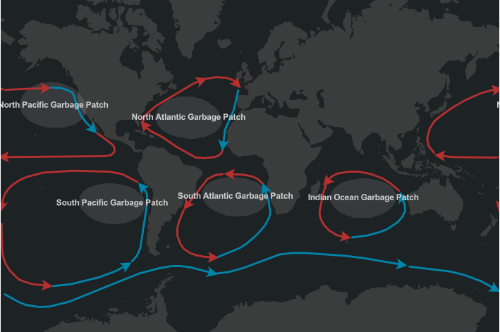
Ocean gyres are large systems of circular ocean currents. On the map, they are outlined by the arrows that represent the direction of the ocean current, and whether that current is warm or cool. The world's five major garbage patches include the North Atlantic, South Atlantic, Indian, North Pacific, and South Pacific. These garbage patches are labeled on the map.
Garbage Patches form in the center of major gyres.
Thinking Question: What happens when surface currents run into the coast of a continent?
When the wind blows along the coastside, it drives the surface layer of the sea. But due to the Coriolis effect, the surface water layer is deflected away from the coast. That surface layer also drives the one located just below it ... which is also deflected offshore due to Coriolis effect.
And so on...
That results in a net offshore mass transport in the upper layers of the sea.
To counteract this mass transport; cold water rises from the depths. This mineral-rich water delights phytoplankton, and therefore, delights zooplankton, fish, ... and fishermen!
Which of the following best re-states this assignment's learning objectives?
Reflect on your understanding of the learning objectives:
Describe how wind patterns and the Coriolis effect drive surface ocean currents | |
|---|---|
Analyze maps and diagrams to explain how ocean gyres form and why garbage patches collect in the center of these circular currents. |
Reflect on your mastery of the success criteria:
Identify that winds push surface currents in the same direction, describe that currents rotate clockwise in the Northern Hemisphere and counterclockwise in the Southern Hemisphere, and explain the Coriolis effect causes this rotation. | |
|---|---|
Analyze maps and diagrams to explain how ocean gyres form and why garbage patches collect in the center of these circular currents. |
Predict: Who will catch the ball?
While the merry-go-round is rotating counterclockwise, the students throw the ball "straight" across.
According to the video, why does the ball appear to curve to an observer on the merry‑go‑round?
What is marine debris?
What is the most common item found in marine debris?
All marine debris is visible.
What is a garbage patch?
Why can't we simply scoop up all of the marine debris from the garbage patch?
Which method is most effective for addressing ocean garbage patches?
In this scenario, what drives the surface layer of the sea?
What causes the surface water layer to be deflected away from the coast?
What is the result of this deflected surface water?
Why is upwelling important for both marine ecosystems and coastal economies?