Use the historical document(s) and the short readings in the left panel to answer the associated questions.
Use the historical document(s) and the short readings in the left panel to answer the associated questions.
Use the reconstructed irrigation record and sketch map to answer the questions. The document describes leaders organizing water from a river into canals and fields. Pay attention to which features are natural and which are built by people, and how shared work shaped community life.

Which statement best explains how shared customs and identity might develop from the activities shown in the document?
Which conclusion is BEST supported about why the settlement is located near the river?
Explain how the physical environment shown in the document could influence daily work in the settlement.
Use at least two details from the map/document (for example, the river, canals, fields, or town). Write a well-formed paragraph.
Describe one way people in the settlement might alter the river valley to meet their needs, and explain one possible environmental benefit or drawback of that change.
Write a well-formed paragraph.
Based on the document, which feature is MOST clearly a human-made change to the environment?
Study the reconstructed record and sketch map. Officials tracked grain in a granary and assigned workers to canals and roads. The map shows a temple, a walled city, fields, and nearby villages. Use these details to explain how geography supported complex society.

Which conclusion is BEST supported about why the granary and fields are shown close to the river and canals?
Based on the document, which map feature BEST shows a city function found in complex civilizations?
Explain how two features on the map (such as the river/canals, road, villages, temple, or granary) could support the growth of a complex society.
Write a well-formed paragraph that uses evidence from the document.
Describe one geographic advantage and one geographic challenge shown or implied by the document for people living in this river valley.
Explain how the society might respond to the challenge. Write a well-formed paragraph.
Which statement BEST connects geography to job specialization in the document?
Study the reconstructed canal order and sketch map. Leaders directed workers to clean canals, build a levee, and store extra water in a basin. A note warns that fields can turn salty if water sits too long. Use the evidence to explain adaptation.

Explain how TWO human-made features in the document (for example, canals, levee, or basin) helped people modify the environment to meet their needs.
Use evidence from the map/document. Write a well-formed paragraph.
Based on the map, which feature is MOST likely to reduce the problem labeled “salty soil”?
Which action in the document BEST shows people adapting to a natural hazard of living near a river?
Describe one environmental challenge shown or implied by the document and explain one response people could use to reduce the negative impact.
Use evidence from the document. Write a well-formed paragraph.
Which conclusion is BEST supported about why leaders would organize canal cleaning and repairs?
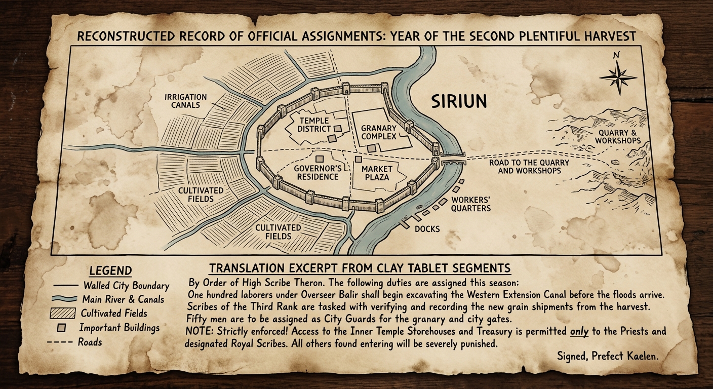
Study the reconstructed work order and map. The river and canals water fields outside the city wall. A temple and granary sit inside the walls, while workers’ housing lies nearby. Leaders assigned canal diggers, scribes, and guards, and restricted access to storehouses.
Explain how the spatial organization on the map (for example, walls, temple/granary, fields, and housing) could reflect a political or social hierarchy.
Use at least two pieces of evidence from the document. Write a well-formed paragraph.
Which statement BEST connects geography to different jobs mentioned in the document?
Based on the document, which location would MOST likely be guarded or restricted?
Which conclusion is BEST supported about how the map shows unequal access to power or wealth?
Describe one way leaders could use control of water or stored grain to maintain authority in the settlement. Use evidence from the document/map. Write a well-formed paragraph.