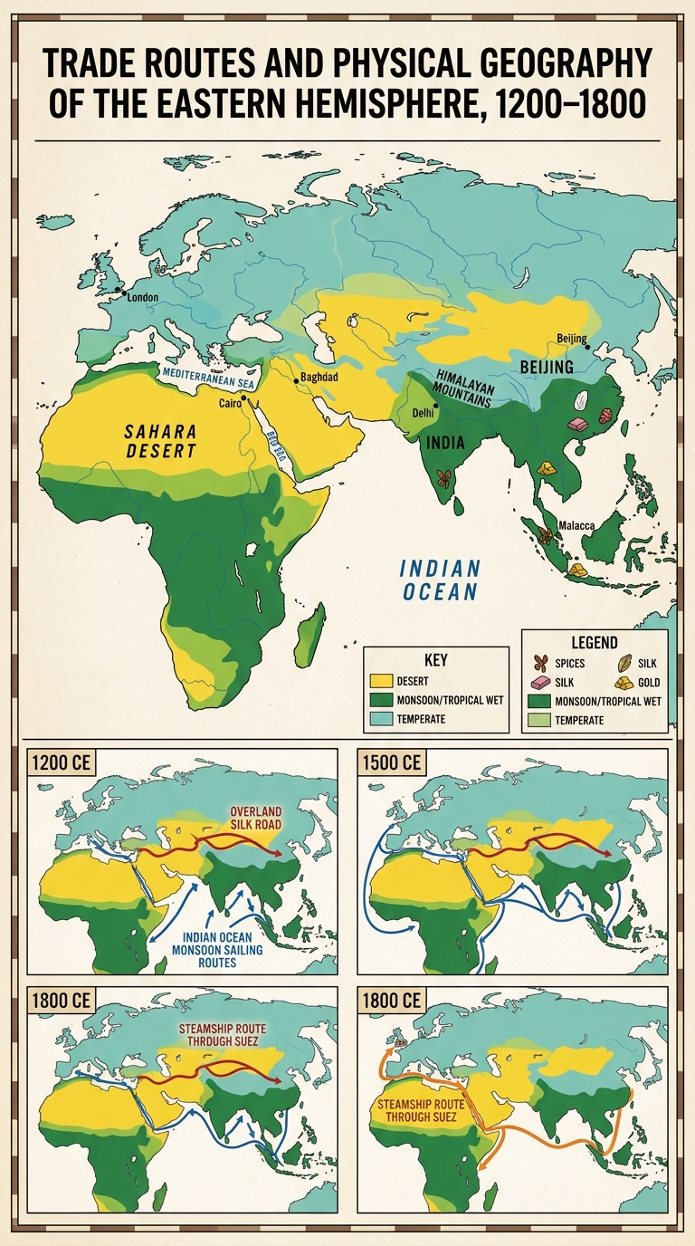
Geographers use maps to track how landforms, climate, and waterways shape human connections over time. The document shows major trade routes in 1200 CE, 1500 CE, and 1800 CE. Use the legend and timeline panels to answer the question.
Use the historical document(s) and the short readings in the left panel to answer the associated questions.
Use the historical document(s) and the short readings in the left panel to answer the associated questions.
Geographers use maps to track how landforms, climate, and waterways shape human connections over time. The document shows major trade routes in 1200 CE, 1500 CE, and 1800 CE. Use the legend and timeline panels to answer the question.
If a historian is looking for the clearest map evidence of increased Europe–South Asia sea connections, which time panel provides the best support?
Which claim is best supported by comparing the 1200 CE and 1500 CE timeline panels?
Describe one change over time shown in the trade routes (1200 CE → 1800 CE). Cite two specific map details: one physical environment feature (climate zone, landform, or body of water) and one route/connection feature. Explain how the physical environment relates to the change.
Evaluate the claim: “Even when technology and routes change, climate zones, landforms, and waterways continue to shape connections between regions.” Use evidence from at least two time panels and cite at least two map features.
Which map evidence best supports the idea that a landform limited overland travel routes in 1200 CE more than in later periods?
Regions are areas that share identifiable characteristics. This document compares the Eastern Hemisphere in 1200 CE, 1500 CE, and 1900 CE. As you review each panel, notice how climate, landforms, and trade routes shape regional connections and help explain continuity and change over time.
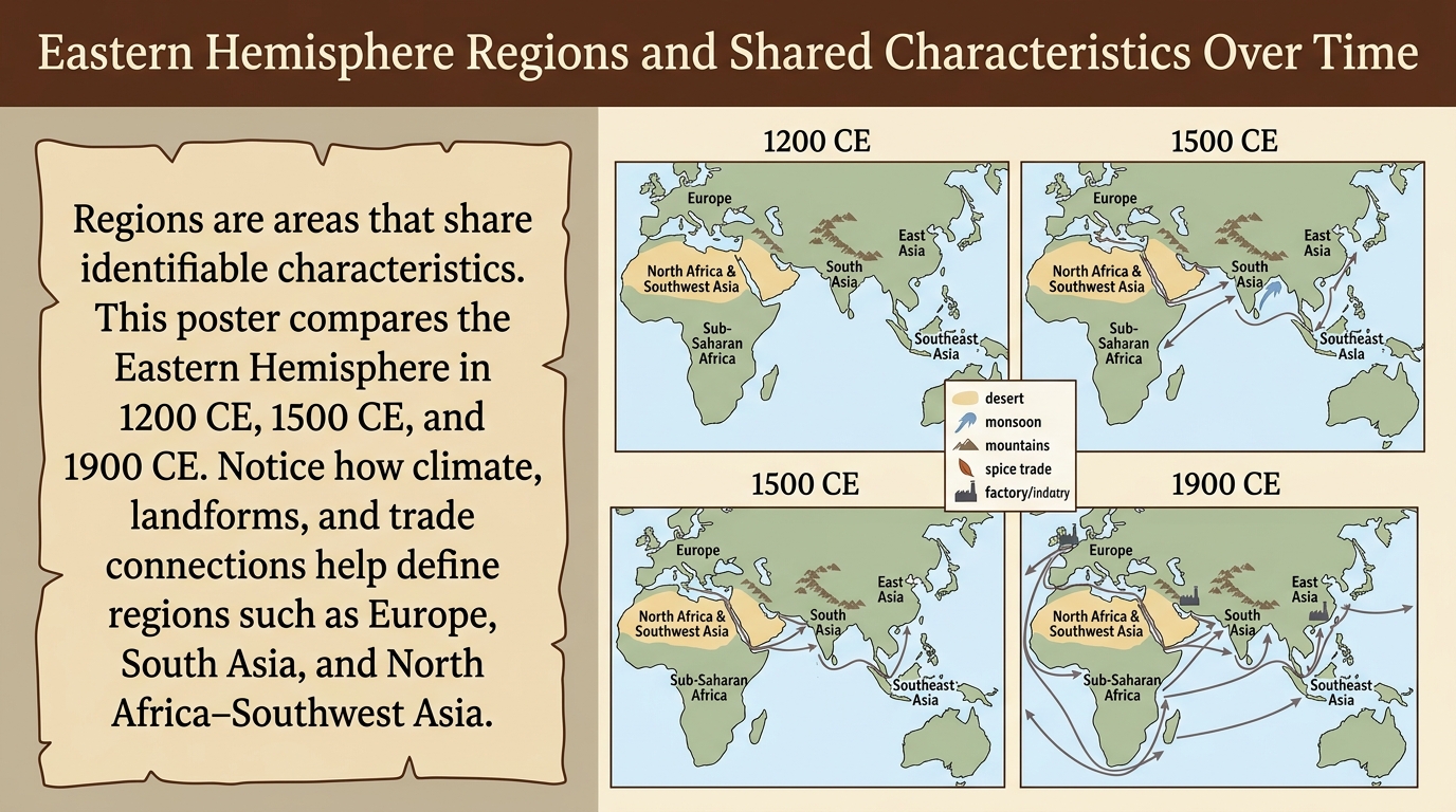
Which poster detail is the clearest evidence that regions are defined by shared characteristics, not only political borders?
Based on the poster’s legend and icons, which region is most strongly associated with monsoon climate and ocean trade across all three time panels?
Choose one region labeled on the poster. Describe one continuity and one change in that region’s connections (trade routes or links) from 1200 CE to 1900 CE. Cite two specific pieces of poster evidence (an icon/legend item and a route or label).
Evaluate the claim: “Because regions are based on shared characteristics, a region’s label can stay the same even when its trade connections change over time.” Use evidence from at least two of the dated panels and cite at least two poster features.
Which statement best describes a change over time shown by comparing the 1200 CE and 1500 CE panels?
Physical environments influence where people settle, how land is used, and how regions connect. This document compares three periods: 500 CE, 1500 CE, and 1900 CE. Use the maps to trace changes and continuities in rivers, trade routes, and population centers.
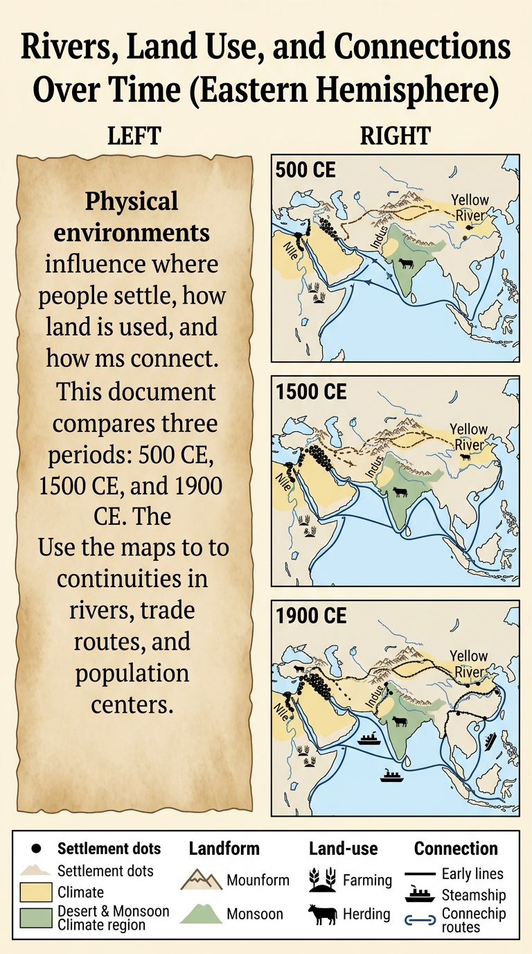
Which inference is best supported by the 1900 CE panel’s combination of rail/steam symbols and major river/coastal nodes?
Which poster evidence best supports the conclusion that rivers often attract dense settlement and farming across time?
Which statement best describes a change in regional connections shown from 500 CE to 1500 CE?
Choose one mapped river region (Nile, Indus, or Yellow River). Describe one continuity and one change in population distribution or land use from 500 CE to 1900 CE. Cite two specific poster details and reference at least two time panels.
Evaluate the claim: “Even when routes and technology change over time, the physical environment continues to shape economic activity and political connections.” Use evidence from at least two time panels and cite at least two poster features.
Cartoons can show how present-day regional problems have roots in the past. In the document, roots represent earlier events and decisions, and branches represent issues today. Use the dated labels to connect causes over time and explain why problems can be multi-causal.
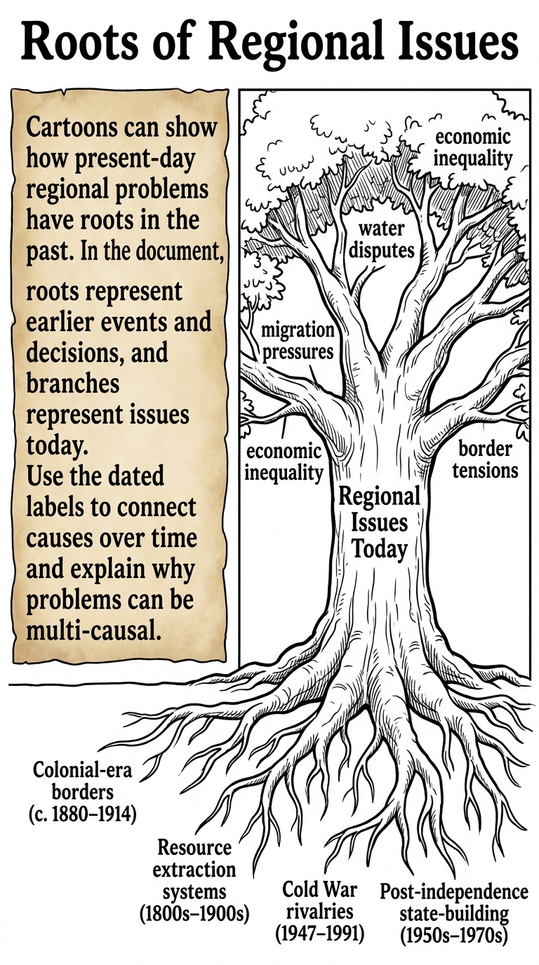
Select one branch label (a present-day issue) from the cartoon. Cite two different root labels and explain how each past factor could contribute to that issue. Use evidence from the cartoon in your explanation.
Which inference is best supported by the cartoon’s pairing of “Resource extraction systems (1800s–1900s)” with a branch labeled “economic inequality”?
Which detail from the cartoon is the clearest evidence for the idea that current problems can be connected to past decisions?
A student claims: “The cartoon argues that all modern issues have only one historical cause.” Which response best evaluates this claim using evidence?
Explain how the dated root labels help you reason chronologically about cause and effect. Cite two dated roots and describe what the timeline suggests about how regional issues develop over time.