Use the historical document(s) and the short readings in the left panel to answer the associated questions.
Customs offices collected taxes (duties) on goods entering or leaving a port. These fees helped governments pay for services and sometimes protected local producers by making imported goods more expensive. Ports on major sea routes often became centers of trade and exchange.
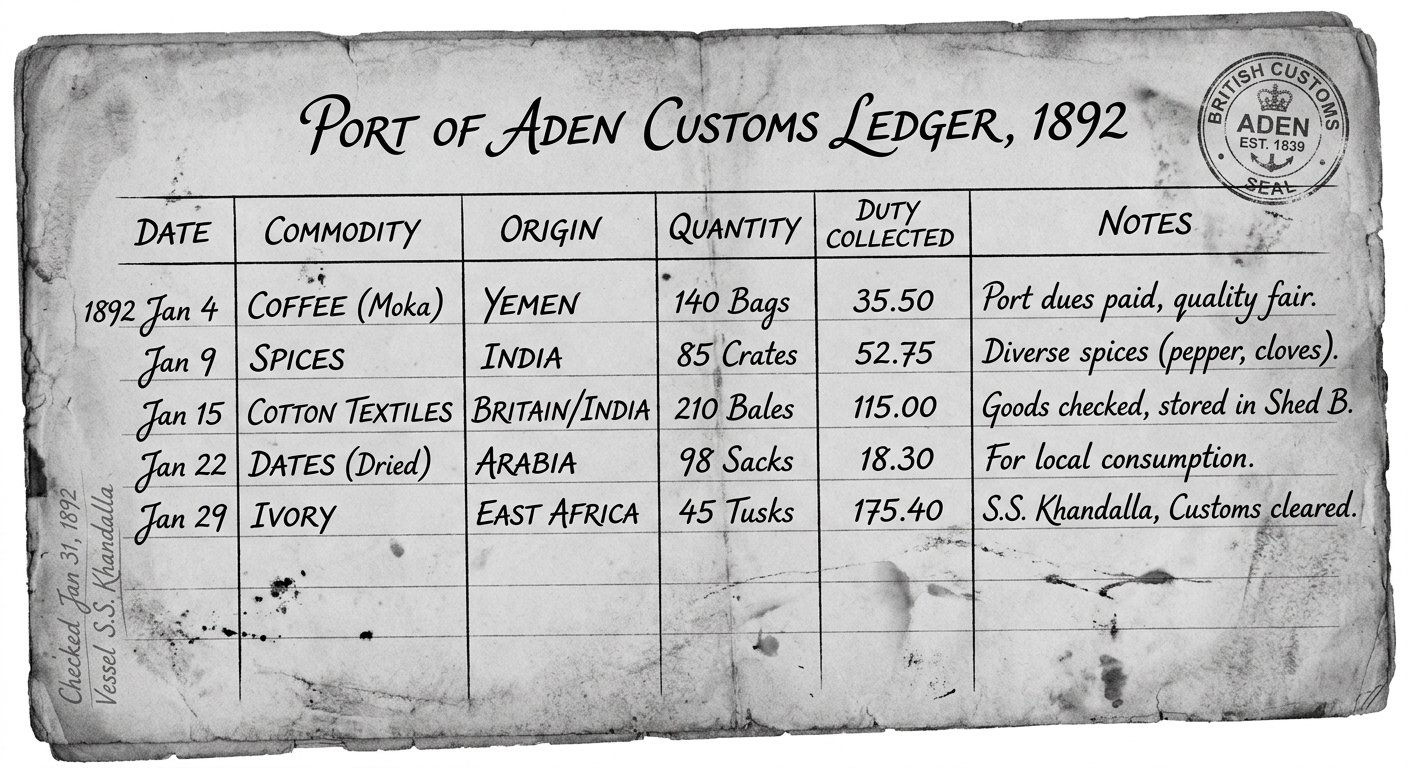
Based on the reading and the ledger, what is the main purpose of the “Duty Collected” amounts?
Which inference about economic connections is best supported by the ledger’s “Origin” entries?
A student claims: “Customs duties always make trade decrease.” Which response best evaluates this claim using the reading and the ledger?
Using evidence from the reading and two specific entries in the ledger (commodities and/or origins), explain one way customs duties could shape an economic system in a port city (for example, government revenue, trade specialization, or protection of local producers).
Choose one commodity listed in the ledger. Make an inference about how physical geography (a body of water, climate zone, or landform) could help explain why that commodity was traded through this port. Cite one map-type feature you would expect to see (for example, “coastal location on a sea route,” “near a monsoon sea route,” or “desert landform limiting overland travel”).
Ports along the Indian Ocean connected different regions through trade. Governments and city-states often charged harbor fees or taxes to fund defense and services. Monsoon winds shaped sailing seasons, influencing which ports became major regional trade hubs and how goods moved between regions.

Which statement best explains how a port’s economic role can help define it as part of a region?
Which inference about an economic system is best supported by the manifest’s “Payment/Tax” (harbor fee) column?
A student argues: “Because monsoon winds shape sailing seasons, ports in the Indian Ocean region would likely become more important at predictable times of year.” Which response best evaluates this claim using the reading and the manifest?
Use evidence from the reading and two different routes on the manifest (departure → destination plus goods) to explain how trade can connect regions into an economic system. In your explanation, describe one way governments could benefit economically from these connections.
Choose one set of connected ports from the manifest (for example, ports around the Indian Ocean). Explain how shared economic activities (types of goods traded, use of sea routes, and port fees) could be used as evidence to define a region. Cite at least two details from the document.
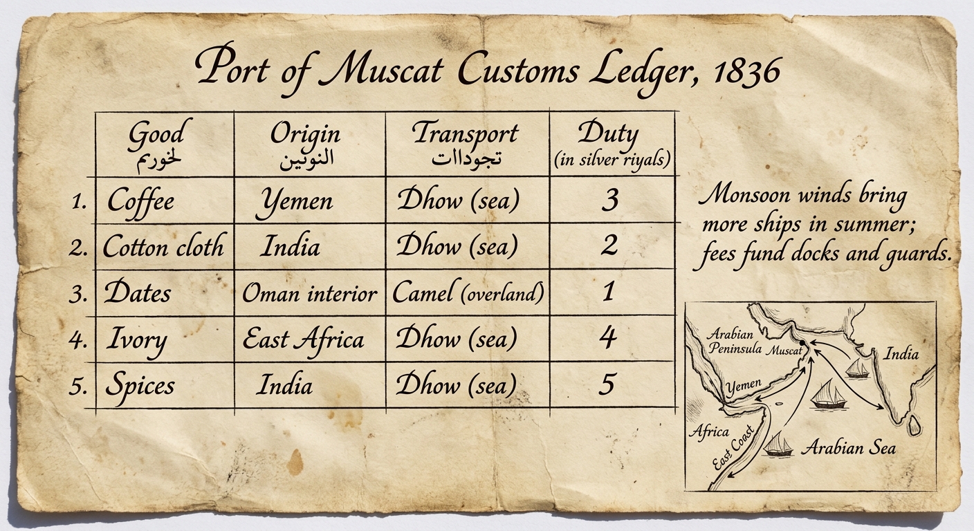
Ports along the Indian Ocean connected different regions through trade. Governments and city-states often charged harbor fees or taxes to fund defense and services. Monsoon winds shaped sailing seasons, influencing which ports became major regional trade hubs and how goods moved between regions.

Which detail from the ledger best supports the conclusion that the physical environment shaped when trade increased at this port?
Which inference about Muscat’s economic connections is best supported by the origins and transport methods listed?
Which statement best explains how collecting duties and harbor fees could support an economic system in Muscat?
Use Figure 1 to explain one way duties or harbor fees could affect trade decisions and political connections (such as cooperation, competition, or control of routes). Cite two specific document details in your explanation.
Using two specific pieces of evidence from Figure 1 (for example, a good/origin entry and the margin note), explain how physical geography could influence economic activity and land use around the Port of Muscat.
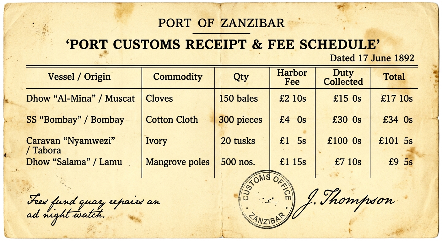
In many Indian Ocean ports, governments collected harbor fees and customs duties on imported and exported goods. This revenue paid for docks, guards, and warehouses, shaping what merchants traded and where ships stopped. Some present-day trade patterns and inequality debates trace back to these earlier systems.

Using evidence from the passage and two specific details from the customs receipt, explain one way harbor fees and duties could shape an economic system in a port city (for example, government revenue, trade specialization, or protection of local producers). Then explain one way that a legacy of this kind of system could relate to a present-day regional issue.
Choose two different shipments on the customs receipt. For each shipment, explain how physical geography (for example, a sea route, seasonal winds, a coastline, or land barriers) could help explain why that commodity was traded through this port. Use at least two specific pieces of document evidence in your response.
Which detail from the document is the clearest evidence that the port government raised revenue from trade?
A student claims: “Customs duties always cause trade to decrease.” Which response best evaluates the claim using the passage and the document?
What inference about Zanzibar’s economic system is best supported by the “Vessel / Origin” entries on the document?