Study the posters. Use its labels, icons, and legend to identify Eastern Hemisphere regions and support conclusions with evidence.
Figure 1.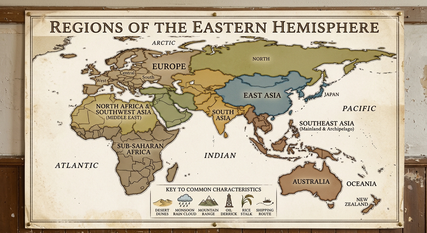
Figure 2.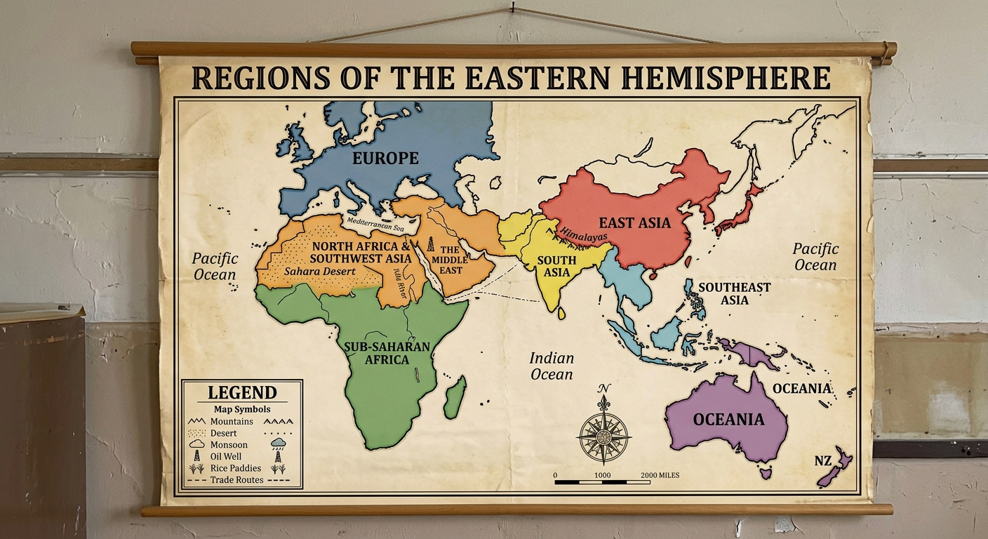
Use the historical document(s) and the short readings in the left panel to answer the associated questions.
Use the historical document(s) and the short readings in the left panel to answer the associated questions.
Study the posters. Use its labels, icons, and legend to identify Eastern Hemisphere regions and support conclusions with evidence.
Figure 1.
Figure 2.
Which region is best supported by the evidence of a monsoon icon and rice symbol grouped together on the poster?
Which pair of regions is best supported by poster evidence as sharing a major desert climate characteristic?
Which evidence from the poster best supports the idea that regions are based on shared characteristics, not only political borders?
Choose one region shown on the poster. Cite two specific poster details (a label and an icon) and explain how they show a shared characteristic of that region.
Evaluate the claim: “Regions in the Eastern Hemisphere are defined only by political borders.” Use two pieces of evidence from the poster to support your evaluation.
Regions are areas that share identifiable characteristics. This document compares the Eastern Hemisphere in 1200 CE, 1500 CE, and 1900 CE. As you review each panel, notice how climate, landforms, and trade routes shape regional connections and help explain continuity and change over time.
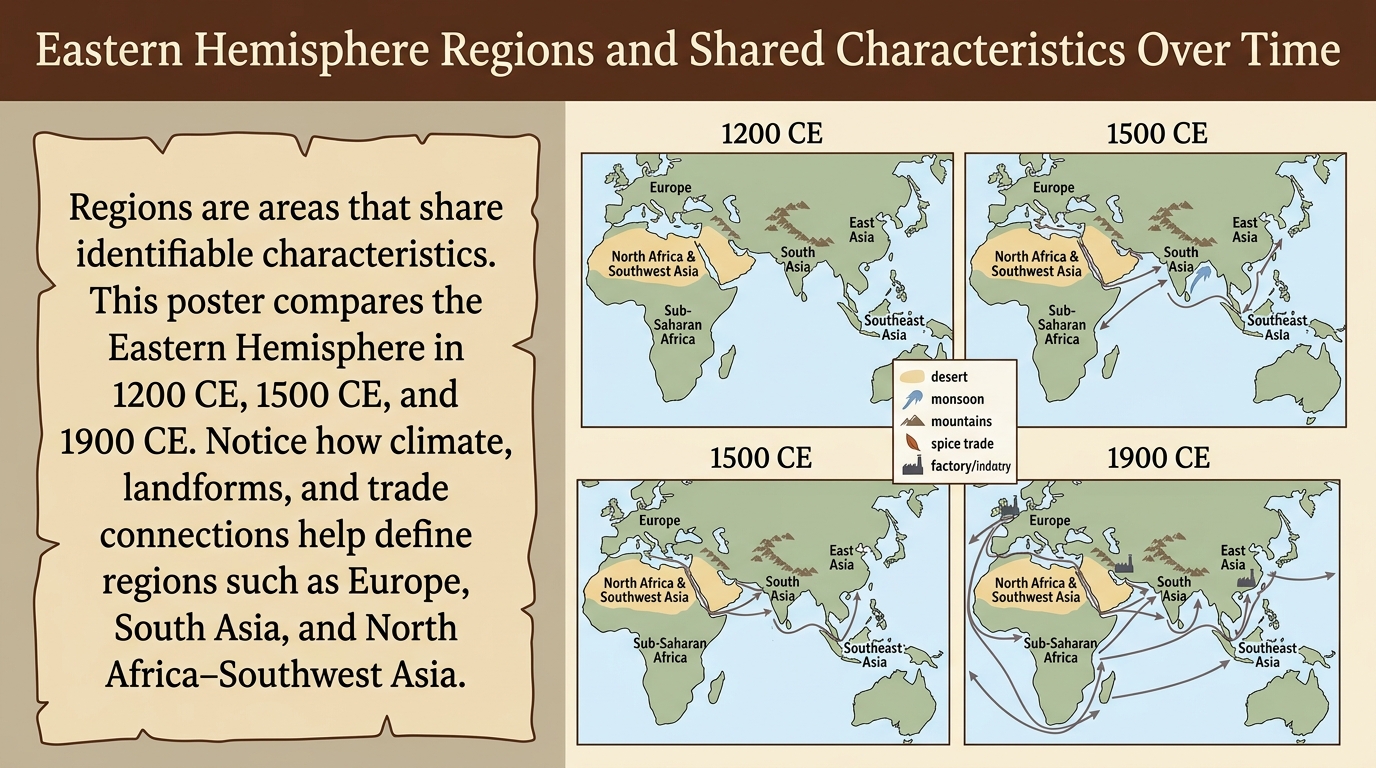
Which poster detail is the clearest evidence that regions are defined by shared characteristics, not only political borders?
Based on the poster’s legend and icons, which region is most strongly associated with monsoon climate and ocean trade across all three time panels?
Choose one region labeled on the poster. Describe one continuity and one change in that region’s connections (trade routes or links) from 1200 CE to 1900 CE. Cite two specific pieces of poster evidence (an icon/legend item and a route or label).
Evaluate the claim: “Because regions are based on shared characteristics, a region’s label can stay the same even when its trade connections change over time.” Use evidence from at least two of the dated panels and cite at least two poster features.
Which statement best describes a change over time shown by comparing the 1200 CE and 1500 CE panels?
Regions are areas that share identifiable characteristics. This document compares Europe and Southeast Asia using climate, landforms, and trade connections in 1500 CE and 1900 CE. Use the legend to compare shared features and to explain how changing connections can reshape how a region is understood.
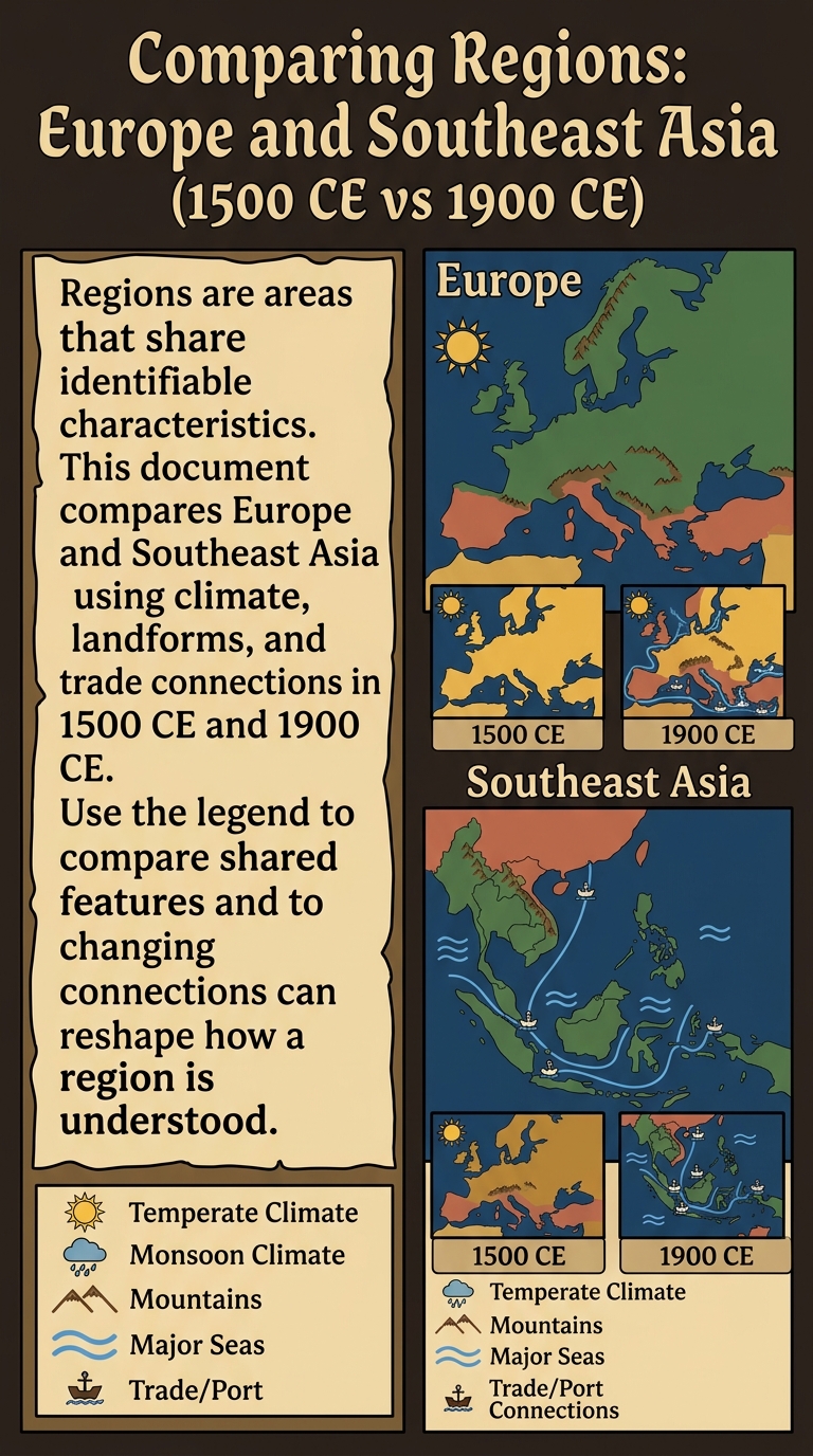
Which statement best contextualizes the change from 1500 CE to 1900 CE shown by the trade/port symbols?
Which poster detail is the clearest evidence that regions are defined by shared characteristics, not only political borders?
Which comparison is best supported by the climate and landform symbols on the poster?
Compare Europe and Southeast Asia using two specific pieces of poster evidence (one from each region). Explain how those features support defining regions by shared characteristics.
Choose one region (Europe or Southeast Asia). Use evidence from the 1500 CE and 1900 CE insets to contextualize how changing connections could affect the region’s economic or cultural characteristics. Cite at least two poster features.
Regions are areas that share identifiable characteristics. This poster map labels major Eastern Hemisphere regions and includes symbols for climate, landforms, bodies of water, and resources. Use the legend to identify patterns and to explain how geographers define regions using evidence, not only political borders.
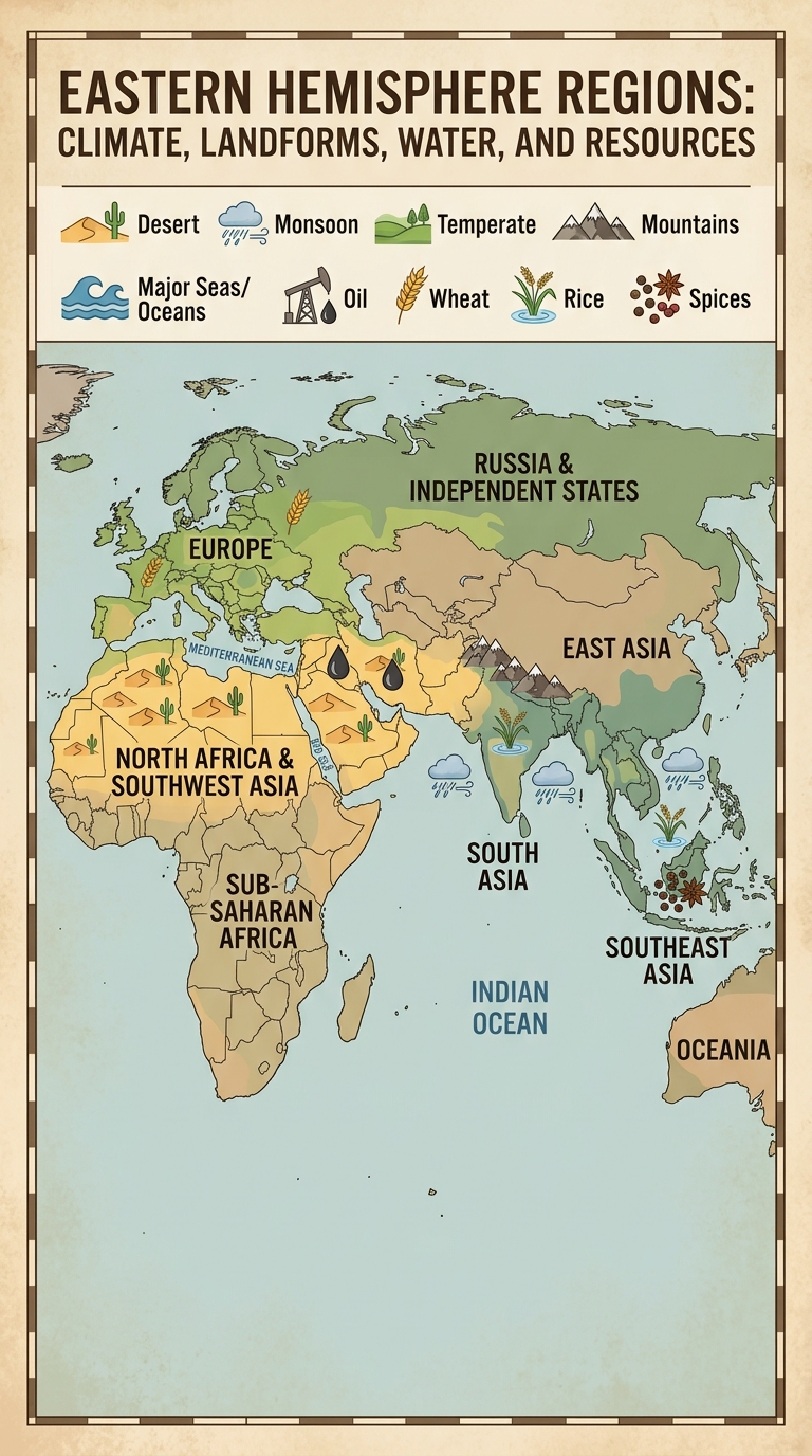
Which region is best supported by the evidence of a monsoon icon and rice symbol grouped together on the map?
Which piece of map evidence best supports the idea that regions can be defined using shared physical characteristics?
Choose one labeled region on the map. Cite two specific map details (one climate icon/zone and one landform or body of water) and explain how they support defining that region by shared characteristics.
Use two map features to make a geographic inference about connections between regions (trade, travel, or cultural exchange). Explain how bodies of water or landforms could encourage or limit those connections. Cite the evidence you use.
Which pair of regions is best supported by the map evidence as sharing a major desert climate characteristic?
Ports along the Indian Ocean connected different regions through trade. Governments and city-states often charged harbor fees or taxes to fund defense and services. Monsoon winds shaped sailing seasons, influencing which ports became major regional trade hubs and how goods moved between regions.
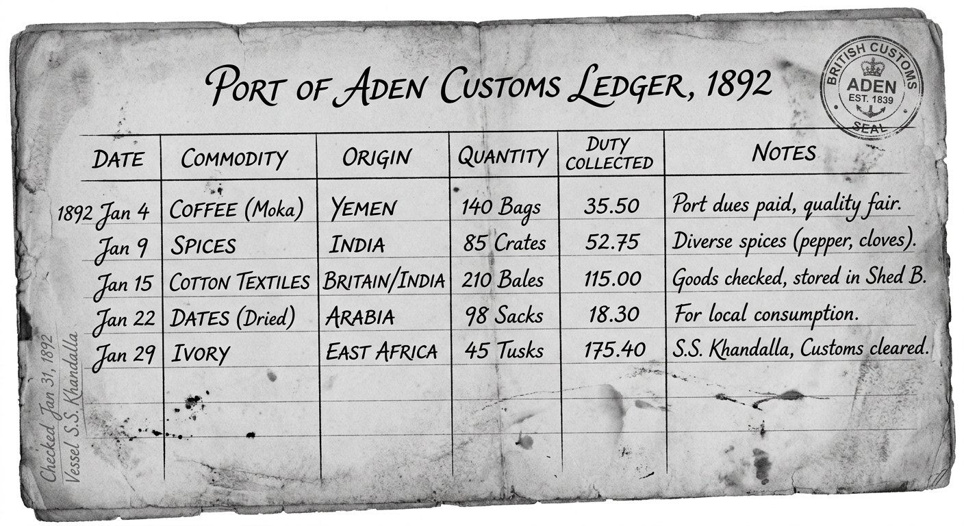
Which statement best explains how a port’s economic role can help define it as part of a region?
Which inference about an economic system is best supported by the manifest’s “Payment/Tax” (harbor fee) column?
A student argues: “Because monsoon winds shape sailing seasons, ports in the Indian Ocean region would likely become more important at predictable times of year.” Which response best evaluates this claim using the reading and the manifest?
Use evidence from the reading and two different routes on the manifest (departure → destination plus goods) to explain how trade can connect regions into an economic system. In your explanation, describe one way governments could benefit economically from these connections.
Choose one set of connected ports from the manifest (for example, ports around the Indian Ocean). Explain how shared economic activities (types of goods traded, use of sea routes, and port fees) could be used as evidence to define a region. Cite at least two details from the document.