Study the posters and their legends. Use their evidence to explain how physical environments influence settlement, land use, and economic connections across regions.
Figure 1.
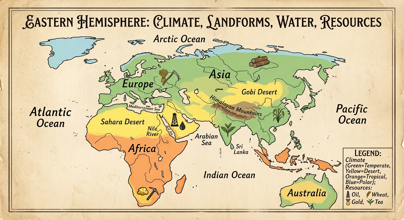
Figure 2.
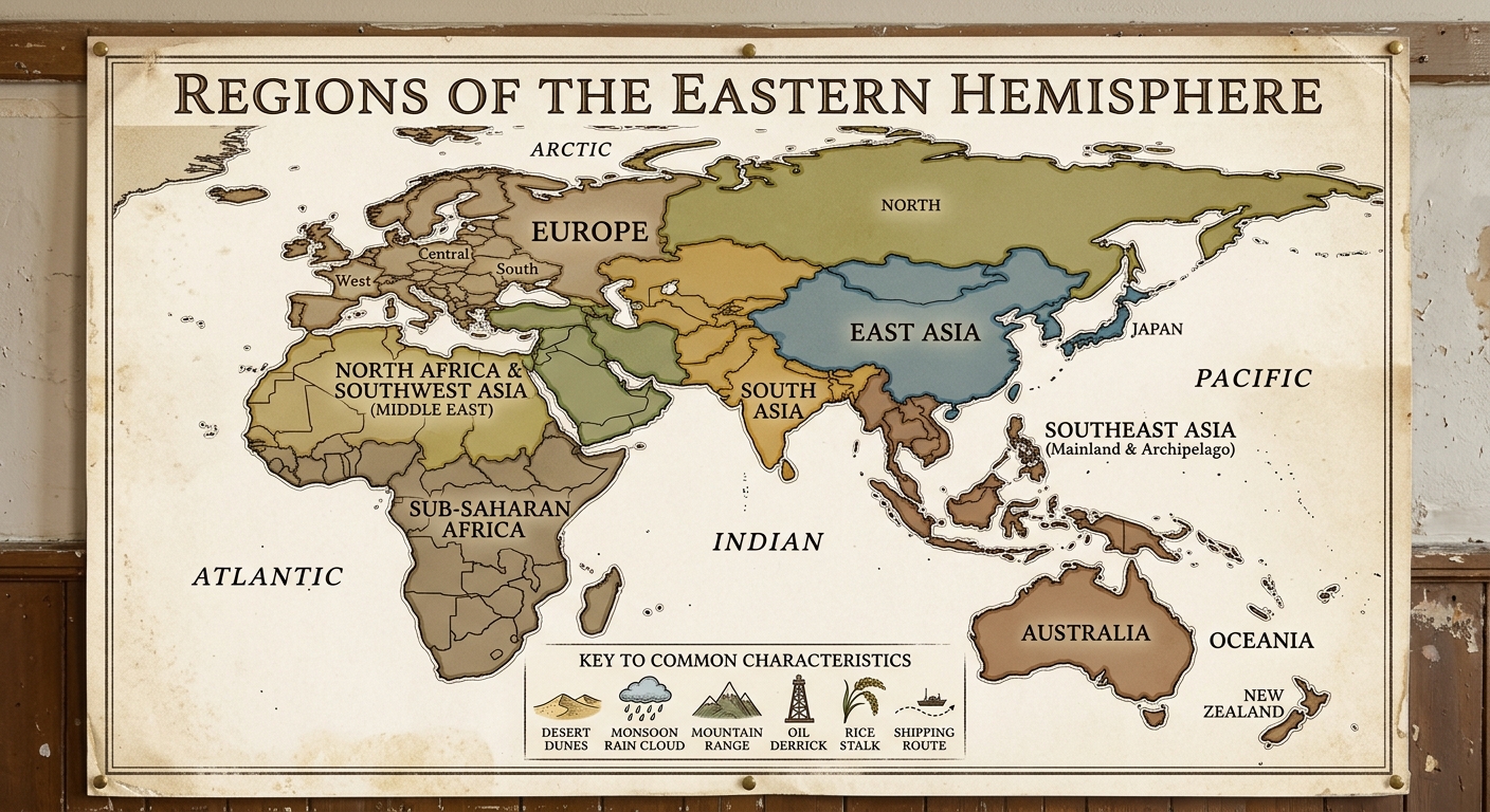
Figure 3.
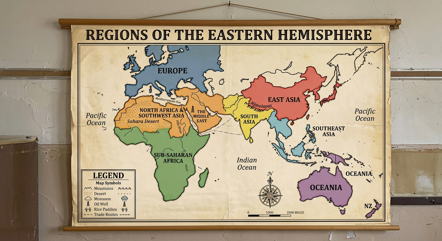
Use the historical document(s) and the short readings in the left panel to answer the associated questions.
Use the historical document(s) and the short readings in the left panel to answer the associated questions.
Study the posters and their legends. Use their evidence to explain how physical environments influence settlement, land use, and economic connections across regions.
Figure 1.
Figure 2.
Figure 3.
A student claims: “Deserts usually support the same land use as monsoon regions.” Which response best evaluates this claim using poster evidence?
Which poster evidence best supports the conclusion that rivers often attract dense settlement and farming?
Which claim is best supported by the poster’s combination of mountains, climate zones, and trade-route symbols?
Explain one way the physical environment could influence population distribution and political connections in the Eastern Hemisphere. Cite two pieces of poster evidence.
Use two specific poster details (a physical feature and a land-use/economic icon) to explain how environment influences economic activity in one region.
Physical environments influence where people settle, how land is used, and how regions connect. This document compares three periods: 500 CE, 1500 CE, and 1900 CE. Use the maps to trace changes and continuities in rivers, trade routes, and population centers.
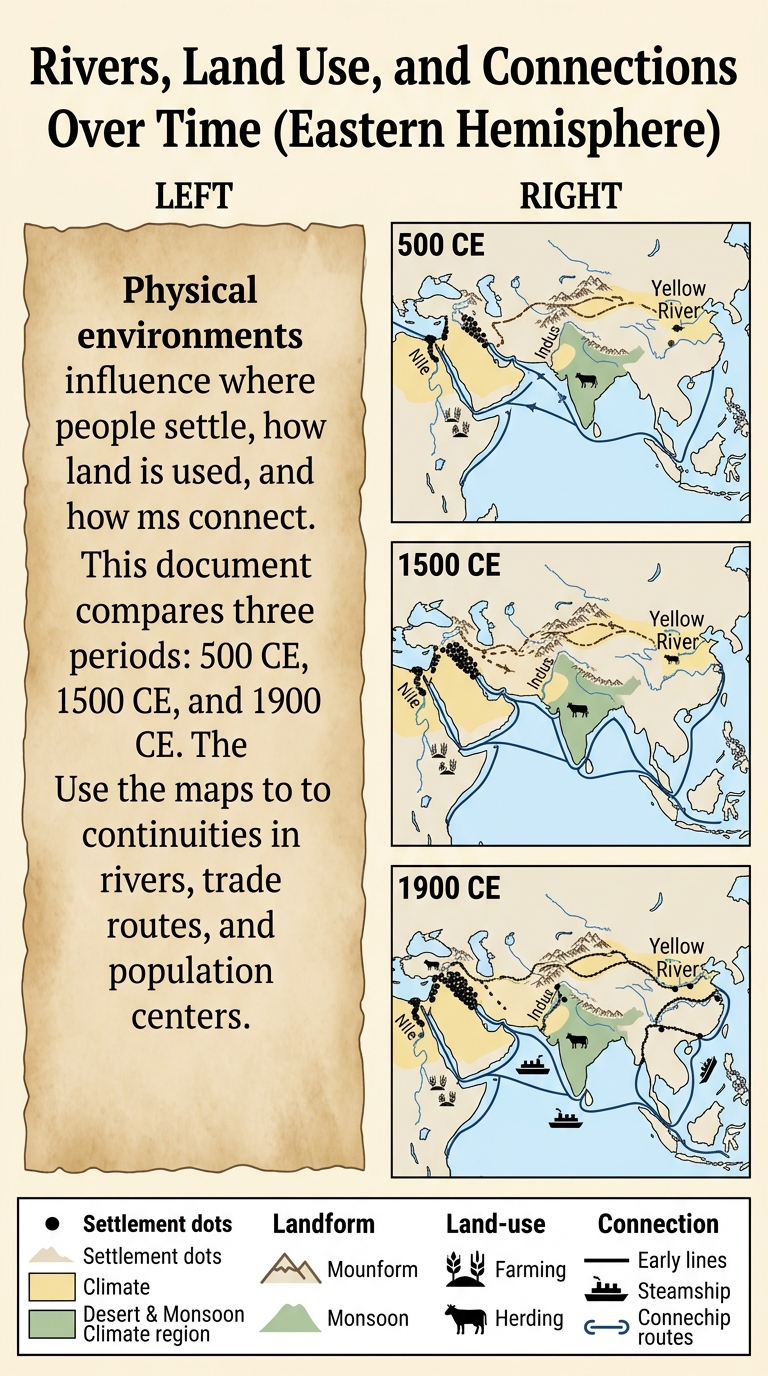
Which inference is best supported by the 1900 CE panel’s combination of rail/steam symbols and major river/coastal nodes?
Which poster evidence best supports the conclusion that rivers often attract dense settlement and farming across time?
Which statement best describes a change in regional connections shown from 500 CE to 1500 CE?
Choose one mapped river region (Nile, Indus, or Yellow River). Describe one continuity and one change in population distribution or land use from 500 CE to 1900 CE. Cite two specific poster details and reference at least two time panels.
Evaluate the claim: “Even when routes and technology change over time, the physical environment continues to shape economic activity and political connections.” Use evidence from at least two time panels and cite at least two poster features.
Physical environments influence settlement, land use, and connections. This document compares North Africa–Southwest Asia and South Asia in 1500 CE and 1900 CE. Use climate, landform, and waterway evidence to compare regions and to contextualize why people farm, trade, and build cities differently over time.
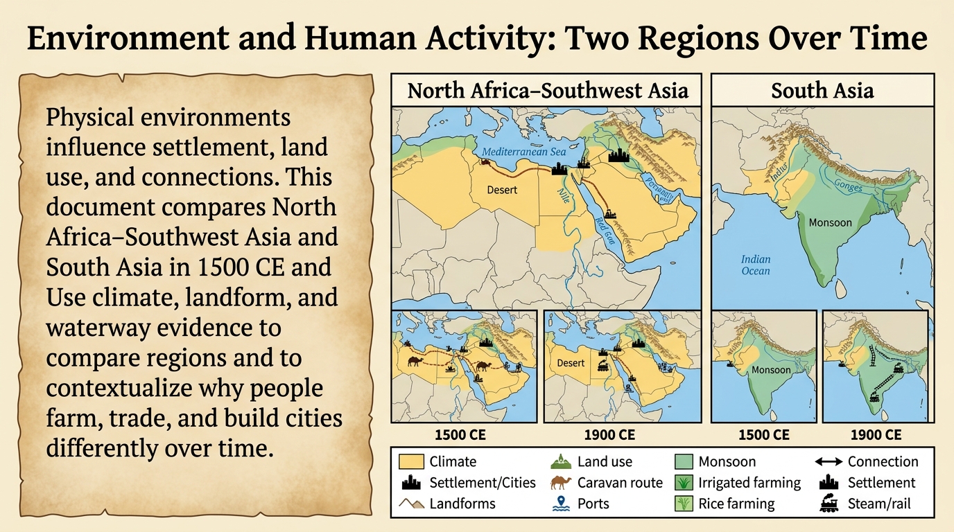
Which comparison is best supported by the poster’s climate and waterway evidence?
Compare the two regions using two specific pieces of evidence (one from each region) from the 1500 CE insets. Explain how the differences could lead to different settlement patterns or economic activities.
Which statement best contextualizes the change from 1500 CE to 1900 CE shown by the connection symbols (ports/steam/rail)?
Choose one region. Use evidence from both the 1500 CE and 1900 CE insets to contextualize how the physical environment influences economic connections over time. Cite at least two poster features.
Which inference about land use is best contextualized by the poster’s desert/river evidence for North Africa–Southwest Asia?
The physical environment influences where people settle, how land is used, and how regions connect. This document compares two river regions in the Eastern Hemisphere. Use evidence from climate zones, landforms, and bodies of water to explain patterns in settlement, farming, trade routes, and political connections.
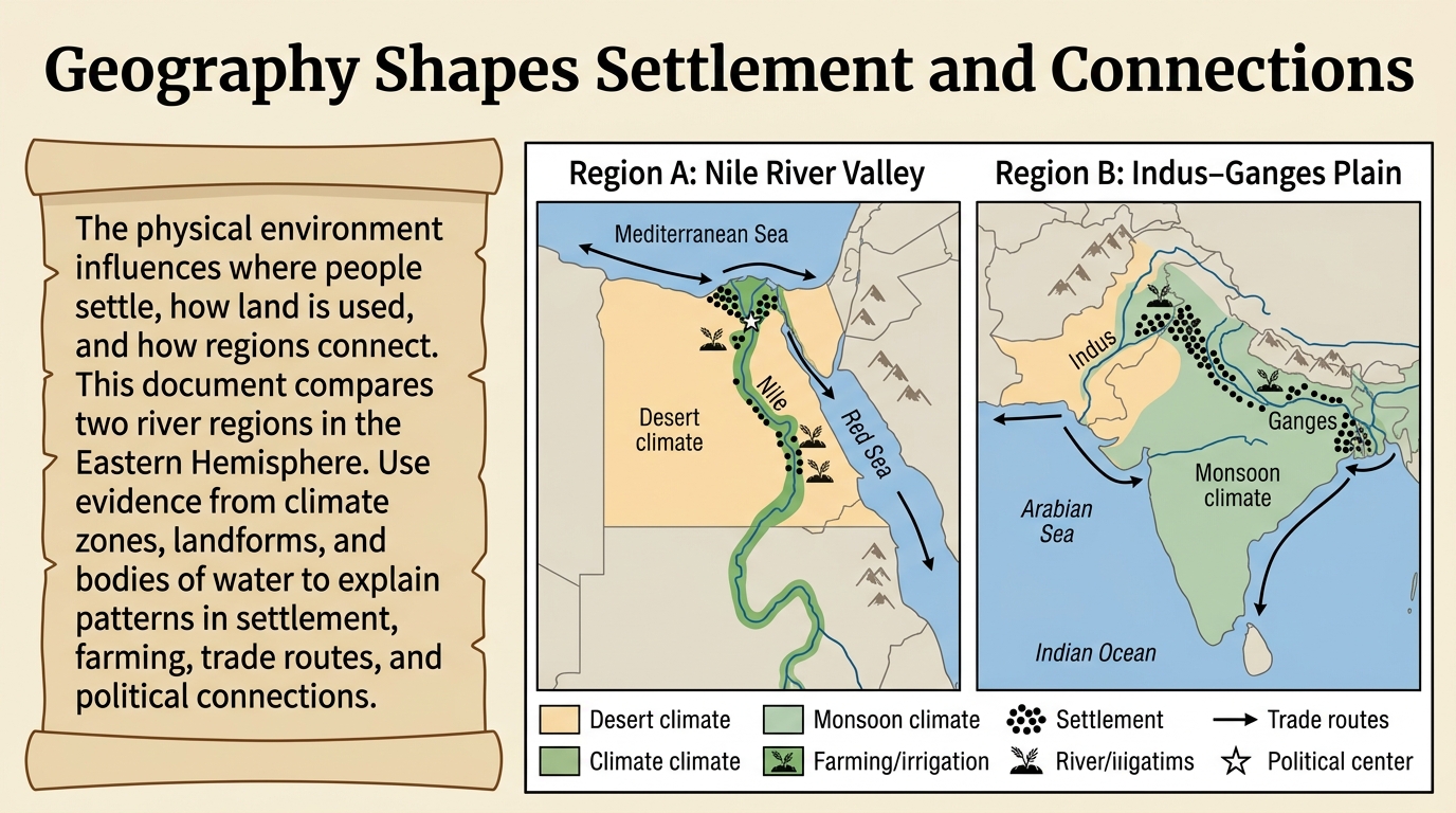
Compare the two regions using two specific pieces of poster evidence (one from each map). Explain how the physical environment could lead to different land use or economic activities in each region.
Which inference about population distribution is best supported by the settlement symbols on both maps?
Which comparison is best supported by the climate evidence on the poster?
Use poster evidence to explain one way the physical environment could influence political connections in either Region A or Region B. Cite two features (for example, a river, sea route, climate zone, or landform) and explain your reasoning.
Which map evidence best supports the conclusion that waterways can strengthen political and economic connections?
Ports along the Indian Ocean connected different regions through trade. Governments and city-states often charged harbor fees or taxes to fund defense and services. Monsoon winds shaped sailing seasons, influencing which ports became major regional trade hubs and how goods moved between regions.
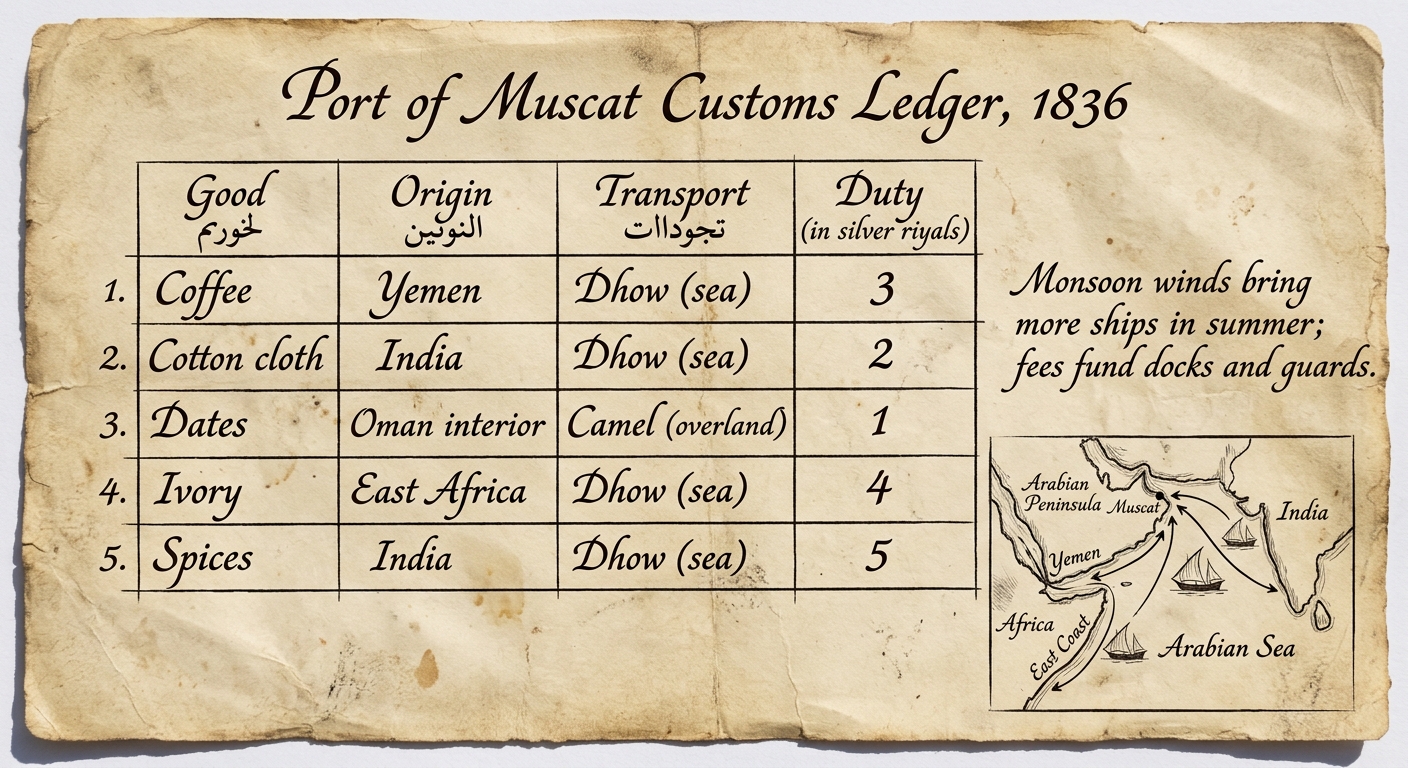
Which detail from the ledger best supports the conclusion that the physical environment shaped when trade increased at this port?
Which inference about Muscat’s economic connections is best supported by the origins and transport methods listed?
Which statement best explains how collecting duties and harbor fees could support an economic system in Muscat?
Use Figure 1 to explain one way duties or harbor fees could affect trade decisions and political connections (such as cooperation, competition, or control of routes). Cite two specific document details in your explanation.
Using two specific pieces of evidence from Figure 1 (for example, a good/origin entry and the margin note), explain how physical geography could influence economic activity and land use around the Port of Muscat.