Use the historical document(s) and the short readings in the left panel to answer the associated questions.
Use the historical document(s) and the short readings in the left panel to answer the associated questions.

An archaeologist mapped artifacts and features in Excavation Unit B3 at a riverside campsite. The drawing shows where items were found, not what happened for sure. Use the hearth, postholes, and tools to infer activities and decide what evidence best supports each claim.
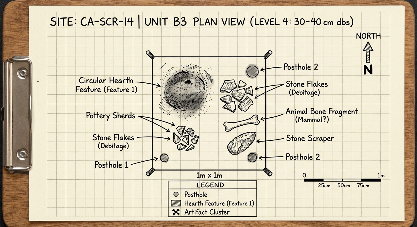
An archaeologist claims, “People likely made or repaired stone tools in Unit B3.” Which evidence best supports this claim?
What is one additional type of evidence an archaeologist could collect at Unit B3 to strengthen conclusions about how people lived there?
Explain why that evidence would help.
Which inference is most supported by the two postholes shown in Unit B3?
Choose one activity (cooking, toolmaking, shelter building, or other).
Identify two specific pieces of evidence from the field sketch that support your choice, and explain how each piece of evidence supports it.
Which item in Unit B3 is the best evidence that people cooked or heated food at this site?
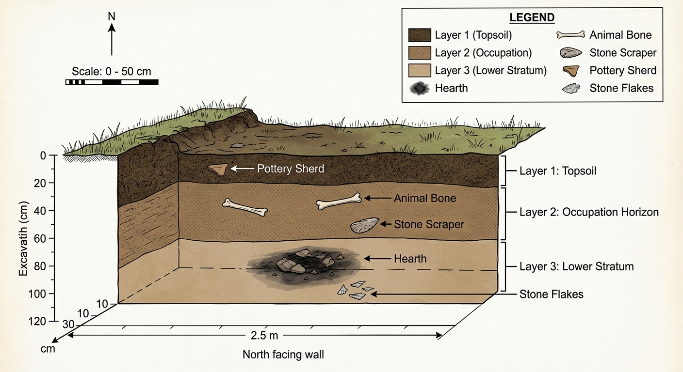
Archaeologists record layers of soil because deeper layers are usually older than layers above them. The image shows a cutaway of a trench at a campsite with three soil layers and objects found in each layer. Use the layers to infer which events happened first.
Name one additional piece of evidence (artifact, feature, or test) that would help confirm the timeline you described.
Explain how it would strengthen chronological reasoning.
Using evidence from two different layers, explain a possible sequence of activities at this site from earliest to latest.
Based on the layers shown, which artifact is oldest?
An archaeologist argues, “People used stone tools at this site before they used pottery.” Which evidence from the trench would best support that claim?
Which conclusion is most reasonable if an animal bone is found in Layer 2 and a hearth feature is found in Layer 3?
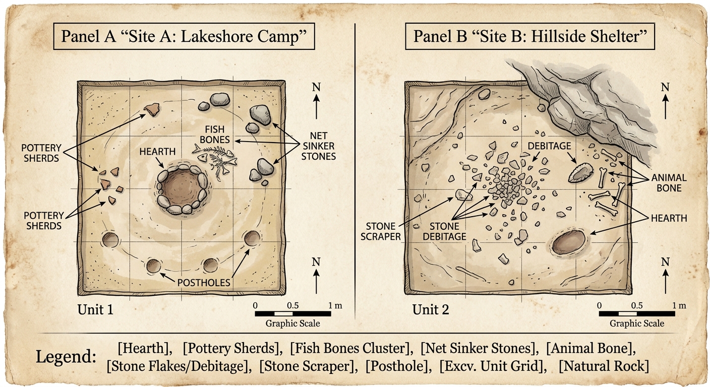
Archaeologists compared artifacts and features from two nearby sites. Site A is beside a lake; Site B is on a hillside. Because objects can point to different activities, archaeologists look for patterns across sites rather than relying on one item alone. Use the evidence to compare how people used each place.
Which statement shows the best conceptual understanding of how archaeologists use evidence to compare sites?
Which claim is best supported when comparing the two sites?
Archaeologists want to decide whether the sites show different uses of space (specialized activities) or mostly the same activities.
Name one additional kind of evidence they could collect to help compare the sites, and explain how it would strengthen their conclusion.
Which piece of evidence most supports the idea that Site B was used more for stone tool production than Site A?
Compare the sites by identifying one likely activity at Site A and one likely activity at Site B.
For each activity, cite two specific pieces of evidence from the sketch and explain how they support your claim.
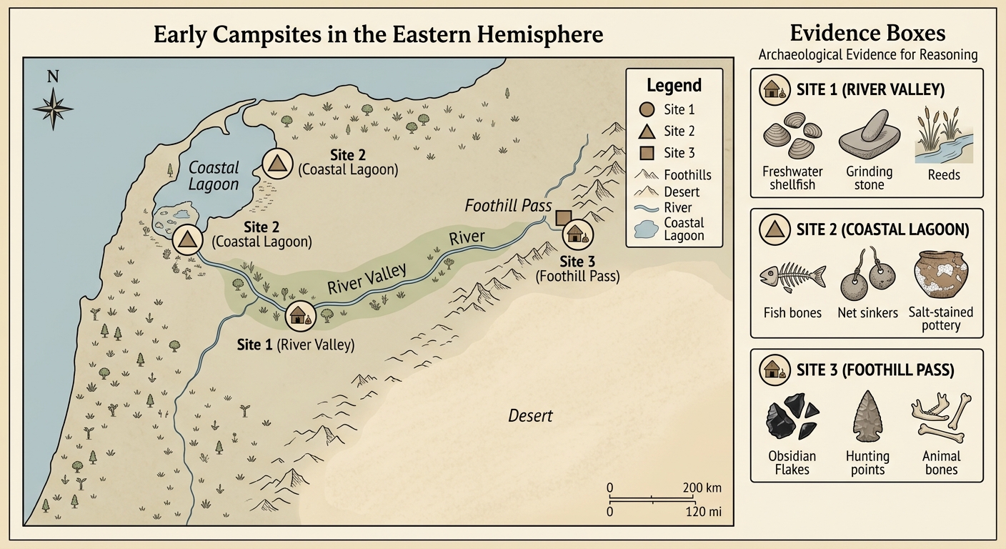
Archaeologists use maps to connect a site’s location to nearby resources. The map shows three early campsites and the artifacts found at each place. Use the physical features (river, coast, foothills, desert) to compare how people adapted their activities to different environments.
Choose two sites. For each site, explain one likely activity and how the location and evidence together support your inference.
An archaeologist claims, “Site 3 was used as a hunting stop during travel through higher ground.”
Which evidence best supports this claim?
Name one additional map-based detail (example: distance to water, elevation, or travel route) that would help archaeologists compare the sites.
Explain how that detail would strengthen geographic reasoning.
Which comparison is most reasonable based on location and evidence?
Which site’s evidence best supports the inference that people relied most on marine resources?
Archaeologists can infer how early people met needs and organized work by studying where artifacts were found. Differences across activity areas can suggest specialization, storage, or exchange. Use the map, labels, and artifact-count table to reason about how resources were produced, distributed, and used.
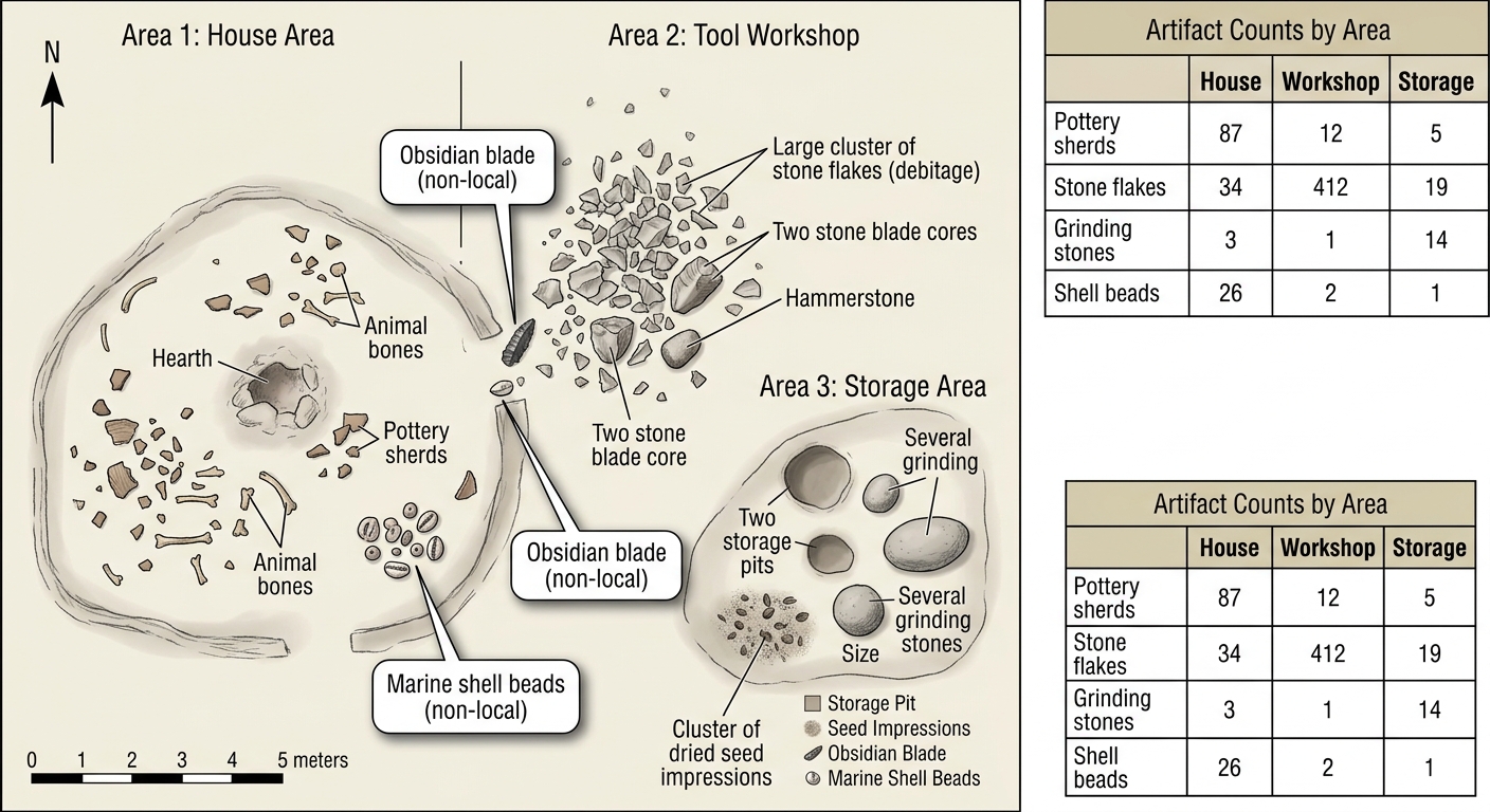
Which inference best connects the Storage Area evidence to an economic idea about managing scarcity?
Name one additional type of evidence an archaeologist could collect to strengthen the conclusion that exchange (trade) occurred at this site.
Explain how that evidence would make the conclusion more reliable.
Which evidence best supports the claim that this group participated in exchange (trade) with other groups?
Which piece of evidence most strongly suggests specialization of labor at this campsite?
Using the sketch and the artifact-count table, explain one way the campsite shows a basic economic system of production and distribution (who made what, and how it was used or shared).
Support your explanation with two specific pieces of evidence.