Twa kɔ nsɛm atitiriw so
Log in
Sign up for FREE
arrow_back
Laabri

6.3c - Early River Valley Civilizations in the Eastern Hemisphere - Practices A through E

star
star
star
star
star
Last updated about 2 months ago
25 Nsɛmmisa
Hyɛ no nsow a efi ɔkyerɛwfo no hɔ:

Use the historical document(s) and the short readings in the left panel to answer the associated questions.

Use the historical document(s) and the short readings in the left panel to answer the associated questions.

Ɛhia
1
6.3.c
DOK.SS.2
Ɛhia
1
6.3.c
DOK.SS.2
Ɛhia
1
6.3.c
DOK.SS.2
Ɛhia
1
6.3.c
DOK.SS.2
Ɛhia
1
6.3.c
DOK.SS.2
Ɛhia
1
6.3.c
DOK.SS.2
Ɛhia
1
6.3.c
DOK.SS.2
Ɛhia
1
6.3.c
DOK.SS.2
Ɛhia
1
6.3.c
DOK.SS.2
Ɛhia
1
6.3.c
DOK.SS.2
Ɛhia
1
6.3.c
DOK.SS.2
Ɛhia
1
6.3.c
DOK.SS.2
Ɛhia
1
6.3.c
DOK.SS.2
Ɛhia
1
6.3.c
DOK.SS.2
Ɛhia
1
6.3.c
DOK.SS.2
Ɛhia
1
6.3.c
DOK.SS.2
Ɛhia
1
6.3.c
DOK.SS.2
Ɛhia
1
6.3.c
DOK.SS.2
Ɛhia
1
6.3.c
DOK.SS.2
Ɛhia
1
6.3.c
DOK.SS.2
Ɛhia
1
6.3.c
DOK.SS.2
Ɛhia
1
6.3.c
DOK.SS.2
Ɛhia
1
6.3.c
DOK.SS.2
Ɛhia
1
6.3.c
DOK.SS.2
Ɛhia
1
6.3.c
DOK.SS.2

Historical Document:

Canal Maintenance Record (Mesopotamia)
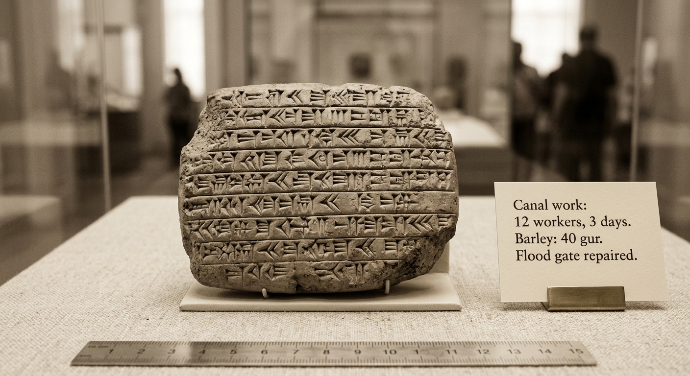
Photo of a clay tablet with cuneiform and a caption summarizing canal work, barley harvest, and a repaired flood gate.

This record from ancient Mesopotamia lists labor used to clear a canal and notes barley collected after repairs to a flood gate. Use details from the document to explain how managing river water supported farming and community needs.
Asemmisa {{asɛmmisaAhyɛnsode}}
1.

Identify one challenge people faced living near major rivers (for example, flooding, drought, or river course changes).

Then, using evidence from the document, explain one method this society used to address that challenge.

Asemmisa {{asɛmmisaAhyɛnsode}}
2.

Which detail from the document is the strongest evidence that people modified their environment?

Asemmisa {{asɛmmisaAhyɛnsode}}
3.

Explain how this document shows both

(1) adapting to the river environment and

(2) modifying it.

Use at least two specific pieces of evidence from the document and connect each piece of evidence to a population need (such as food supply or protection).

Asemmisa {{asɛmmisaAhyɛnsode}}
4.

Which conclusion is BEST supported by the document about how Mesopotamians met food needs?

Asemmisa {{asɛmmisaAhyɛnsode}}
5.

The record lists “12 workers, 3 days” for canal work. What does this BEST suggest about water management in this society?

Historical Document:

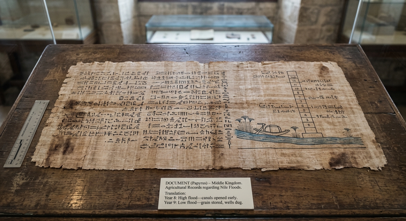
Nile Flood Record (Egypt)

Photo of an Egyptian papyrus with hieroglyphs and a curator label comparing a high-flood year and a low-flood year on the Nile.

This Egyptian record compares two Nile flooding years. It notes actions taken after a high flood and after a low flood. Use the sequence of events in the document to explain how people responded over time to changing river conditions.

Asemmisa {{asɛmmisaAhyɛnsode}}
6.

Which conclusion is BEST supported when you compare Year 8 to Year 9 in the document?

Asemmisa {{asɛmmisaAhyɛnsode}}
7.

Use evidence from the document to explain a cause-and-effect chain across the two years:

How did the flood level in each year lead to the actions recorded?

Include at least two pieces of evidence and keep your explanation in chronological order.

Asemmisa {{asɛmmisaAhyɛnsode}}
8.

According to the document’s timeline, which action happened AFTER the low-flood year?

Asemmisa {{asɛmmisaAhyɛnsode}}
9.

Which sequence BEST represents the order of events described in the document?

Asemmisa {{asɛmmisaAhyɛnsode}}
10.

Identify one way the document shows people modifying their environment over time.

Use the document’s order of events to explain why that modification would help meet a population need (food supply, water access, or protection).

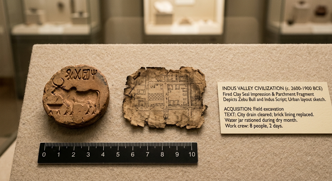
Historical Document:

Drain and Water-Use Record

(Indus River Valley)

Museum-style photo of an Indus Valley seal impression and a curator label describing drain repair and water rationing during a dry month.

This record describes city workers clearing a drain and replacing its brick lining. It also notes that households rationed water jars during a dry month. Use these details to compare how this society both adapted to and modified its environment to meet community needs.

Asemmisa {{asɛmmisaAhyɛnsode}}
11.

Explain how the actions recorded would make sense for a city located near a river that sometimes floods and sometimes runs low.

Use evidence from the document and connect it to at least one population need (health, protection, or food supply).

Asemmisa {{asɛmmisaAhyɛnsode}}
12.

Compare how the society responded to two different needs:

(1) sanitation or floodwater control and

(2) water availability during dry conditions.

Provide at least two specific pieces of evidence and explain what each response suggests about community organization.

Asemmisa {{asɛmmisaAhyɛnsode}}
13.

Which action described in the document is the BEST example of adapting to environmental conditions rather than changing the environment?

Asemmisa {{asɛmmisaAhyɛnsode}}
14.

Which detail from the document is the strongest evidence that people modified their environment?

Asemmisa {{asɛmmisaAhyɛnsode}}
15.

Which comparison is BEST supported by the document’s two main actions (drain repair and water rationing)?

Historical Document:

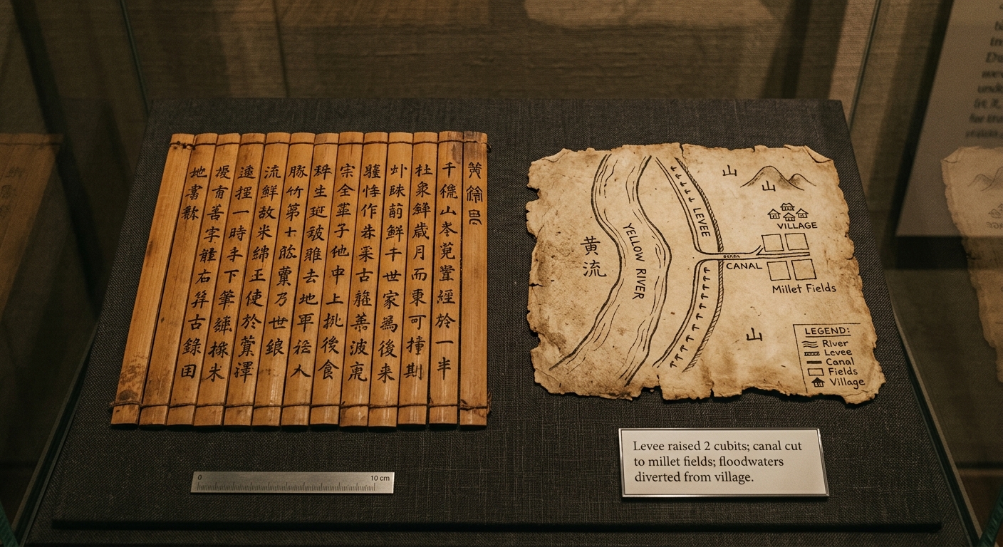
Levee and Canal Plan (Yellow River Valley)

Museum-style photo of a bamboo-slip record and a simple map showing a levee and canal along the Yellow River.

This record includes a simple map of the Yellow River showing a raised levee and a canal leading to fields. It also notes that floodwaters were diverted away from a village. Use the map and notes to explain how people used geography to manage river risks and water supply.

Asemmisa {{asɛmmisaAhyɛnsode}}
16.

Based on the map, what is the MOST likely geographic purpose of the levee (dike) placed along the river?

Asemmisa {{asɛmmisaAhyɛnsode}}
17.

Which map feature is the BEST evidence that people modified their environment to increase food production?

Asemmisa {{asɛmmisaAhyɛnsode}}
18.

Compare the geographic problems that a river can cause in this region (flooding and changing river levels) to the solutions shown in the document.

Explain how each solution matches a specific problem, using evidence from the map/notes.

Asemmisa {{asɛmmisaAhyɛnsode}}
19.

Use evidence from the map and notes to explain how the society used geographic features (river location, nearby fields, and settlement location) to meet TWO different needs.

Include at least two specific pieces of evidence.

Asemmisa {{asɛmmisaAhyɛnsode}}
20.

Which conclusion is BEST supported when you consider the village, river, and fields together on the map?

Historical Document:

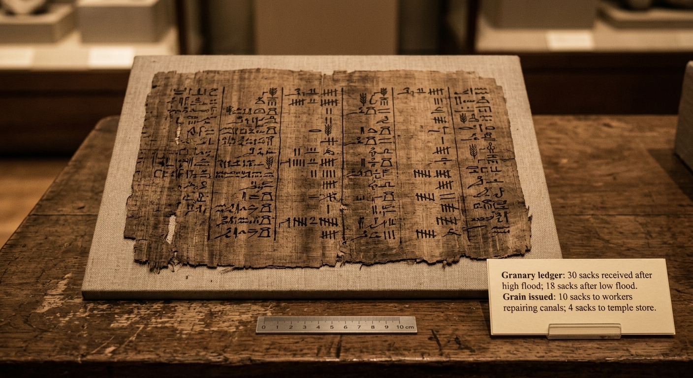
Granary Account Ledger (Nile River Valley)

Museum-style photo of an ancient papyrus grain ledger with a curator label listing grain collected and grain issued for canal repairs.

This Egyptian ledger records grain collected in the granary after different Nile flood levels. It also lists grain issued to workers who repaired canals and to a temple store. Use the entries to explain how river management and economic decisions helped meet community needs.

Asemmisa {{asɛmmisaAhyɛnsode}}
21.

Compare two uses of grain in the ledger (for canal workers and for a temple store).

What does this comparison suggest about how the society prioritized needs in its economy?

Use evidence from the document.

Asemmisa {{asɛmmisaAhyɛnsode}}
22.

Using evidence from the ledger, explain how this society used an economic system (record keeping, storage, and distribution) to respond to changing river conditions.

Include at least two specific pieces of evidence.

Asemmisa {{asɛmmisaAhyɛnsode}}
23.

How does the ledger BEST connect environmental conditions to economic outcomes?

Asemmisa {{asɛmmisaAhyɛnsode}}
24.

Which conclusion about the economy is BEST supported by the ledger entries?

Asemmisa {{asɛmmisaAhyɛnsode}}
25.

Which detail from the ledger BEST shows an economic decision about how resources were allocated?