Use the historical document(s) and the short readings in the left panel to answer the associated questions.
Historical Document:
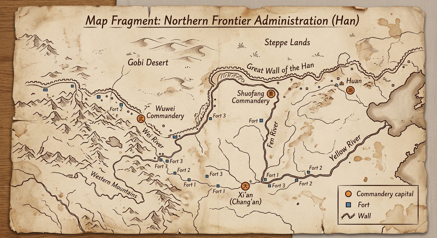
This translated map fragment shows parts of the Han Empire’s northern frontier. Officials marked commandery capitals near rivers, forts on key routes, and a defensive wall along the steppe edge. These features suggest how geography shaped government control and border security.
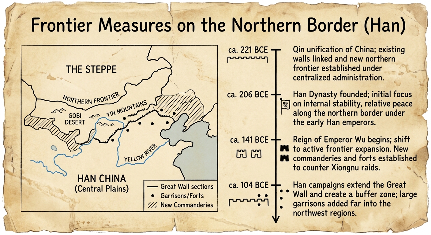
Using evidence from BOTH the map and the reading, explain how geographic features influenced how the Han government controlled its northern frontier.
Include at least two specific details from the document (for example: rivers, mountains, forts, commandery capitals, or the wall).
Imagine the wall line on the map did NOT exist.
Based on the map’s geography, what change might the Han government have made to its political or military organization to secure the frontier?
Support your answer with evidence from the document.
Based on the document, which geographic factor most directly helps explain why many commandery capitals are placed near the Yellow River?
Which piece of evidence from the document most strongly shows that the Han government used political organization to manage the frontier?
Which claim is BEST supported by evidence from the map’s wall line and the nearby desert/steppe region?
Historical Document:

Reading (40–50 words): This translated document combines a frontier map with a short timeline of border policies. It lists dated measures—new commanderies near rivers, forts on key routes, and wall extensions along the steppe edge. Together, the dates and locations show how frontier geography shaped changing government control over time.
Which piece of evidence best supports the idea that geography influenced changes in political control over time?
According to the document’s timeline, which frontier measure happened LAST?
Which statement best explains the chronological relationship shown between forts on key routes and wall extensions along the steppe edge?
Using evidence from BOTH the dates and the map symbols, explain how the Han government’s frontier organization changed over time in response to geography.
Include at least two specific details (dates, rivers, forts, commanderies, wall, steppe, or mountains).
Choose ONE dated entry from the timeline and explain how it helps you understand cause and effect on the frontier.
What geographic challenge is implied, and what political or military response is shown? Support with evidence from the document.
Historical Document:

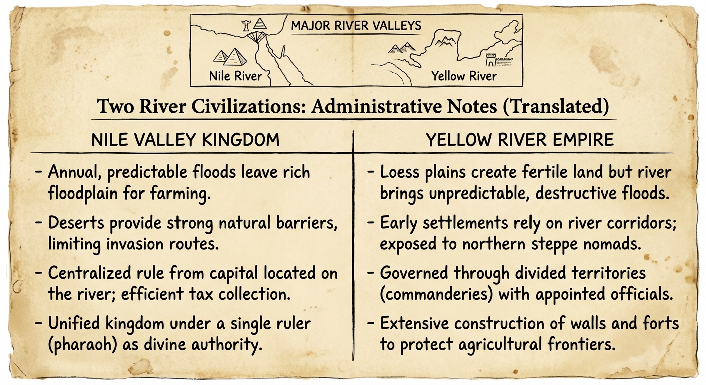
This translated comparison chart summarizes how two river civilizations organized government. It links predictable Nile flooding and surrounding deserts to centralized rule, and it links Yellow River corridors and nearby steppe frontiers to commanderies, forts, and walls. Use the notes as evidence.
Which comparison is BEST supported by the document’s notes?
Which piece of evidence from the document best supports the idea that geography shaped political structures differently in the two regions?
A student claims: “Because the Nile floods were predictable, rulers could collect taxes and organize labor more easily.”
Which detail from the document best supports this claim?
Using evidence from the document, compare how geography influenced government organization in the Nile Valley Kingdom and the Yellow River Empire.
Include at least one specific detail from EACH column.
Contextualize the Yellow River Empire’s use of commanderies, forts, or walls by explaining what geographic problem these features were meant to address. Use at least two specific details from the document as evidence.
Historical Document:

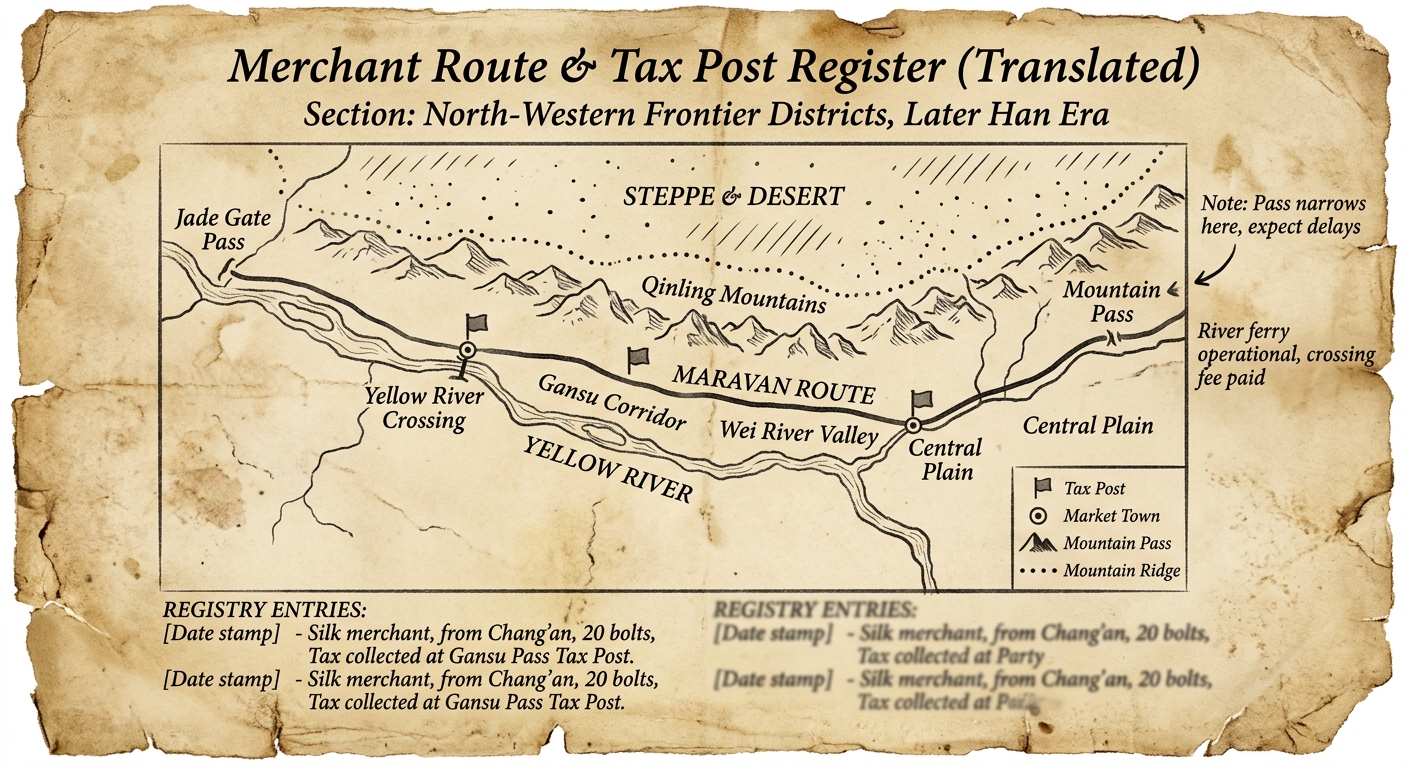
This translated map-register traces a major route from river crossings through mountain passes to the steppe edge. It labels tax posts at narrow passes and near ferries, and it marks market towns by river valleys. These details show how geography shaped government control of trade and movement.
Based on the document, why would the government place a tax post at a mountain pass?
Which claim is BEST supported by the location of tax posts near ferries and passes?
Contextualize this document by explaining why controlling routes from river valleys through passes toward the steppe might matter to a classical empire’s political structure. Use evidence from the document to support your explanation.
Using evidence from BOTH the map and the reading, explain how at least two geographic features shaped where the government placed tax posts or market towns.
Cite specific details from the document.
Which piece of evidence from the map best supports the idea that rivers influenced where towns developed?
Historical Document:

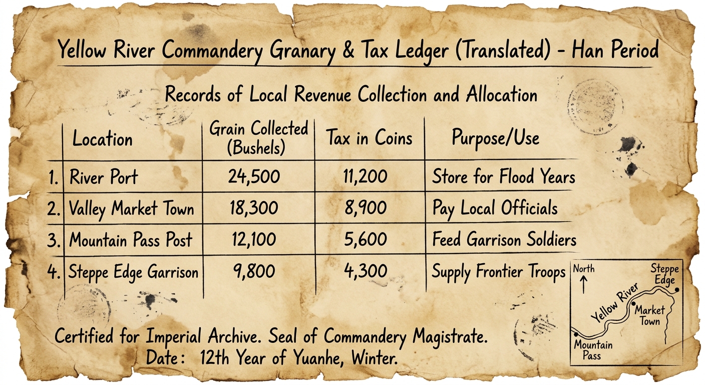
This translated Han ledger records taxes collected in a Yellow River frontier commandery. Officials listed grain and coin taxes from a river port, valley market town, mountain-pass post, and steppe-edge garrison. The entries show how geography shaped trade routes, state revenue, and spending for defense and administration.
Based on the document, which location is MOST likely to have higher grain collections because it can move food easily by water?
Which claim about the Han economic system is BEST supported by the ledger’s mix of grain and coin taxes?
A student says, “This ledger proves the Han economy depended only on coins.”
Evaluate the claim using evidence from the document and explain what the ledger suggests about the economic system.
Using evidence from BOTH the table and the map inset, explain how geography could affect where the Han government collected revenue and how it used that revenue.
Include at least two specific details from the document.
Which evidence from the document most strongly shows a link between frontier geography and government spending priorities?