Twa kɔ nsɛm atitiriw so
Log in
Sign up for FREE
arrow_back
Laabri

6.7b - Interactions Across The Eastern Hemisphere - Practices A through E

star
star
star
star
star
Last updated about 2 months ago
25 Nsɛmmisa
Hyɛ no nsow a efi ɔkyerɛwfo no hɔ:

Use the historical document(s) and the short readings in the left panel to answer the associated questions.

Use the historical document(s) and the short readings in the left panel to answer the associated questions.

6.7.b
DOK.SS.2
DOK.SS.2
6.7.b
DOK.SS.2
DOK.SS.2
6.7.b
DOK.SS.2
Ɛhia
1
6.7.b
DOK.SS.2
Ɛhia
1
6.7.b
DOK.SS.2
Ɛhia
1
6.7.b
DOK.SS.2
Ɛhia
2
6.7.b
DOK.SS.2
Ɛhia
2
6.7.b
DOK.SS.2
Ɛhia
1
6.7.b
DOK.SS.2
Ɛhia
2
6.7.b
DOK.SS.2
Ɛhia
2
6.7.b
DOK.SS.2
Ɛhia
1
6.7.b
DOK.SS.2
Ɛhia
1
6.7.b
DOK.SS.2
Ɛhia
1
6.7.b
DOK.SS.2
Ɛhia
1
6.7.b
DOK.SS.2
Ɛhia
1
6.7.b
DOK.SS.2
Ɛhia
2
6.7.b
DOK.SS.2
Ɛhia
2
6.7.b
DOK.SS.2
Ɛhia
1
6.7.b
DOK.SS.2
Ɛhia
1
6.7.b
DOK.SS.2
Ɛhia
1
6.7.b
DOK.SS.2
Ɛhia
2
6.7.b
DOK.SS.2
Ɛhia
2
6.7.b
DOK.SS.2
Ɛhia
1
6.7.b
DOK.SS.2
Ɛhia
1
6.7.b
DOK.SS.2
Ɛhia
2
6.7.b
DOK.SS.2
Ɛhia
2
6.7.b
DOK.SS.2
Ɛhia
1
6.7.b
DOK.SS.2

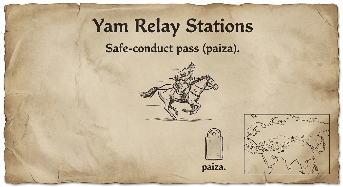
Replica parchment-style document about Mongol relay stations and a safe-conduct pass, with an inset Eurasia trade-route map showing East–West connections.

Mongol rulers created relay stations for messengers and issued safe-conduct passes to merchants and travelers. These policies made long-distance travel more predictable across much of Eurasia. As travel increased, goods, technologies, and ideas moved more frequently between East Asia, Central Asia, and Europe.
Asemmisa {{asɛmmisaAhyɛnsode}}
1.

Based on the inset map, what can you infer about connections across Eurasia during the Mongol conquests?

Asemmisa {{asɛmmisaAhyɛnsode}}
2.

Which detail from the document best supports the idea that Mongol rule encouraged long-distance trade?

Asemmisa {{asɛmmisaAhyɛnsode}}
3.

If travel became more predictable under Mongol rule, which result is most supported by the reading stimulus?

Asemmisa {{asɛmmisaAhyɛnsode}}
4.

What is one limitation of using only this document and map to understand the Mongols’ impact on Eurasia?

Name one additional type of source a historian could use to strengthen the conclusion.

Asemmisa {{asɛmmisaAhyɛnsode}}
5.

Using evidence, explain how the Mongols acted as “agents of change and cultural diffusion.”

Use one piece of evidence from the document or map and one piece of evidence from the reading stimulus.

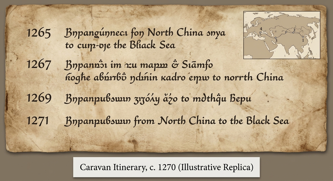
Illustrative replica Mongol-era caravan itinerary listing four dated travel stops (1265–1271) with an inset Eurasia route map showing numbered stops.

Under Mongol rule, merchants could travel long distances more safely and predictably. This itinerary lists dates and stops along an overland route from East Asia to the western edge of Eurasia. When travel became easier, connections grew and exchanges increased over time.

Asemmisa {{asɛmmisaAhyɛnsode}}
6.

Which stop happened third in time, based on the dated itinerary?

Asemmisa {{asɛmmisaAhyɛnsode}}
7.

Identify one limitation of using this single itinerary to understand changes over time during Mongol rule.

Then name one additional type of source that could help a historian confirm the timeline of increased exchange.

Asemmisa {{asɛmmisaAhyɛnsode}}
8.

Using chronological evidence, explain how this itinerary supports the idea that Mongol rule increased connections across Eurasia.

Use two specific dates or time references from the document.

Asemmisa {{asɛmmisaAhyɛnsode}}
9.

Which statement best uses chronological evidence from the itinerary to support the idea that Mongol rule fostered connections?

Asemmisa {{asɛmmisaAhyɛnsode}}
10.

Which inference about East–West connections is best supported by the order of locations and dates in the document and map?

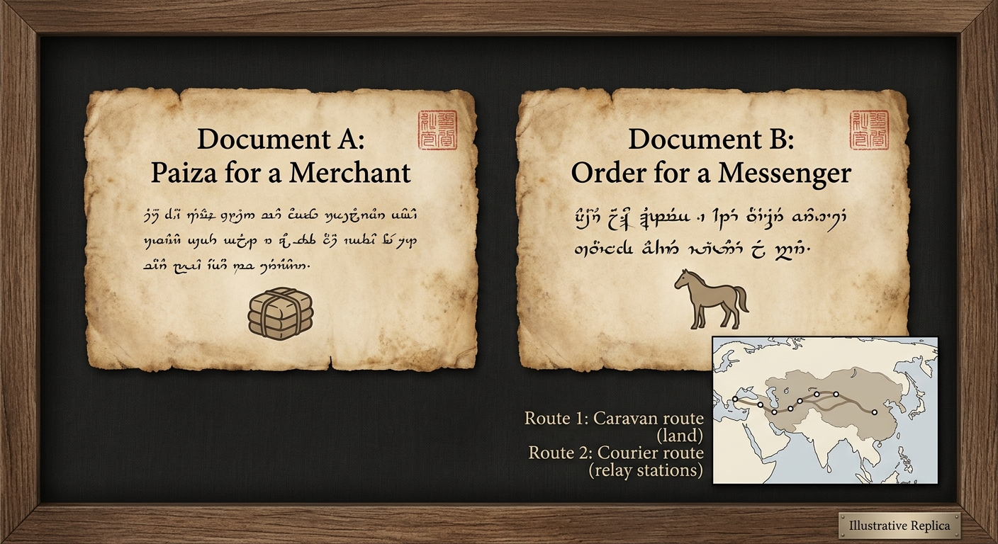
Illustrative replica showing two Mongol-era travel documents (merchant pass and messenger order) side-by-side, with a small Eurasia map inset highlighting a caravan route and a courier relay route.

Mongol rulers governed many peoples across Eurasia. To manage communication and trade, they supported relay stations for messengers and issued safe-conduct passes to merchants. In this context, movement of people and goods increased, connecting distant regions and encouraging the spread of ideas, technologies, and products.

Asemmisa {{asɛmmisaAhyɛnsode}}
11.

Which statement best uses information from the reading stimulus to explain why both documents mattered in their historical context?

Asemmisa {{asɛmmisaAhyɛnsode}}
12.

How does the map inset help contextualize Documents A and B?

Asemmisa {{asɛmmisaAhyɛnsode}}
13.

Which comparison between Document A and Document B is best supported by the evidence in the image?

Asemmisa {{asɛmmisaAhyɛnsode}}
14.

Explain how governing a large, diverse empire could lead Mongol rulers to create policies like those shown in Documents A and B.

Use one piece of evidence from the image or reading in your explanation.

Asemmisa {{asɛmmisaAhyɛnsode}}
15.

Using evidence from Documents A and B and the reading stimulus, explain one similarity and one difference in how the Mongols supported connections across Eurasia.

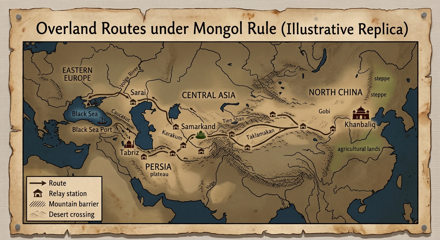
Illustrative replica parchment map of Eurasia showing overland routes under Mongol rule with labeled regions, major trade cities, relay stations, and geographic barriers like mountains and deserts.

The Mongol Empire stretched across many environments, including deserts, mountains, and grasslands. Under Mongol rule, travelers used overland routes linking East Asia, Central Asia, Persia, and Europe. Relay stations and protected roads helped caravans cross long distances and move goods and ideas between regions.

Asemmisa {{asɛmmisaAhyɛnsode}}
16.

Based on the map, which pair of regions is most directly connected by the overland routes shown?

Asemmisa {{asɛmmisaAhyɛnsode}}
17.

How does the map best support the claim in the reading that Mongol rule connected distant regions?

Asemmisa {{asɛmmisaAhyɛnsode}}
18.

Which geographic feature shown on the map would most likely slow caravan travel and make relay stations especially important?

Asemmisa {{asɛmmisaAhyɛnsode}}
19.

Using geographic evidence from the map and the reading, explain how relay stations and routes helped people and goods move across different environments in Eurasia under Mongol rule.

Asemmisa {{asɛmmisaAhyɛnsode}}
20.

Choose one city or node shown on the map and explain why its location could make it an important place for trade and cultural diffusion during Mongol rule.

Use evidence from the map to support your answer.

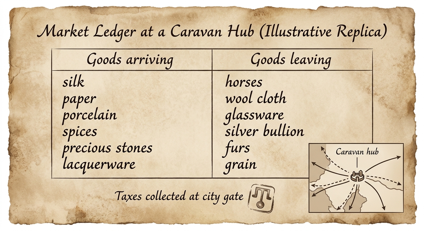
Illustrative replica market ledger from a Mongol-era trade hub listing goods arriving and leaving, with a note about taxes and an inset diagram of routes meeting at a caravan hub.

Mongol rulers protected major overland routes and used officials to manage trade at key cities. Merchants paid taxes or fees at gates and in markets. When travel became safer, more caravans arrived and more goods were exchanged. These economic policies helped connect distant regions across Eurasia.

Asemmisa {{asɛmmisaAhyɛnsode}}
21.

How does the reading stimulus help explain the “taxes/fees collected” note on the ledger?

Asemmisa {{asɛmmisaAhyɛnsode}}
22.

Which conclusion about economic change under Mongol rule is most supported by the document and reading together?

Asemmisa {{asɛmmisaAhyɛnsode}}
23.

Economic reasoning: Using evidence from the ledger and the reading, explain how Mongol policies could affect supply and demand in a caravan hub market.

Use at least one specific example from the goods listed.

Asemmisa {{asɛmmisaAhyɛnsode}}
24.

Using evidence, explain one way the Mongols acted as “agents of change” in the economy of Eurasia.

Use one piece of evidence from the document and one from the reading stimulus.

Asemmisa {{asɛmmisaAhyɛnsode}}
25.

Which evidence from the document best supports the idea that cities under Mongol rule functioned as trade hubs in an economic system?