Use the historical document(s) and the short readings in the left panel to answer the associated questions.
Historical Document: Indian Ocean Trade
(c. 1200 C.E.)
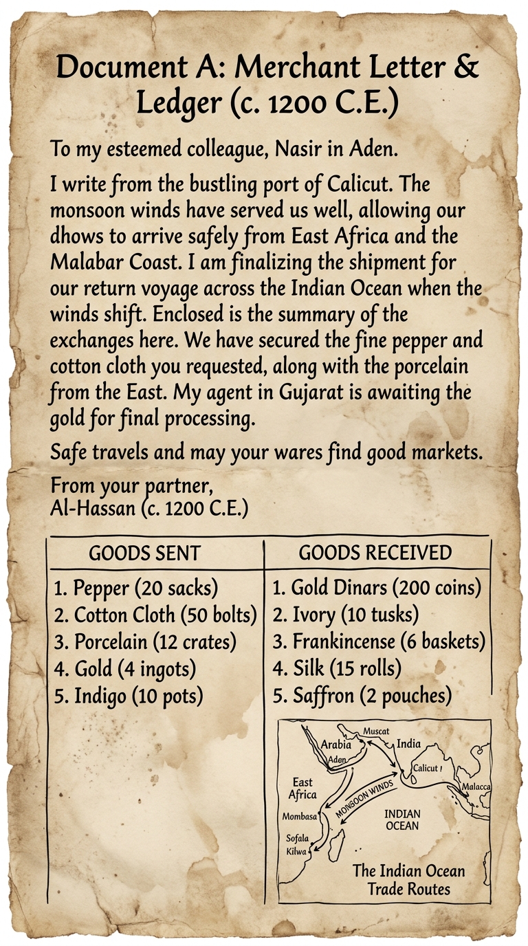
Document A is a translated merchant letter and ledger from about 1200 C.E. It describes using monsoon winds to travel the Indian Ocean and lists goods exchanged between ports in East Africa, Arabia, India, and Southeast Asia. Use the letter, ledger, and map sketch as evidence.
A student says, “Trade networks only moved goods, not people or ideas.” Use Document A to support or challenge this statement.
Your answer must reference at least one feature of the document as evidence.
Suppose a historian wants to argue that ideas and technologies could spread along Indian Ocean routes.
Which piece of evidence from Document A would be the strongest starting point for that argument?
Use evidence from Document A to explain how geography and climate influenced Indian Ocean trade.
Include at least two specific details from the document (for example, the winds, ports, or goods).
Which claim is best supported by the combined evidence in the letter and the ledger in Document A?
Based on Document A, which factor most directly helped merchants travel between ports on the Indian Ocean trade network?
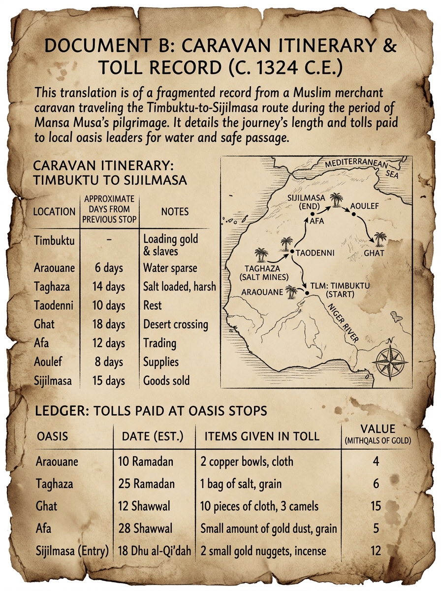
Historical Document: Trans-Saharan Caravan Travel (c. 1324 C.E.)

Document B is a translated itinerary and toll record from about 1324 C.E. It lists caravan stops and the days of travel between them as merchants crossed the Sahara. It also records tolls paid at oases. Use the sequence of stops and timing as evidence.
Which statement best describes the order of travel shown in Document B?
A classmate says, “This document cannot tell us anything about movement over time because it does not include exact calendar dates.”
Use evidence from Document B to support or challenge this statement.
Using Document B, explain how the sequence of stops provides evidence that Trans-Saharan trade depended on organized routes.
Include at least two specific details (stops, days, or tolls).
Which inference about planning is best supported by the timeline of stops and tolls in Document B?
A student claims, “The longest stretch of travel happened at the very beginning of the journey.”
Which evidence from Document B would be most useful to check this claim?
Historical Document: Two Trade Networks (c. 1300 C.E.)

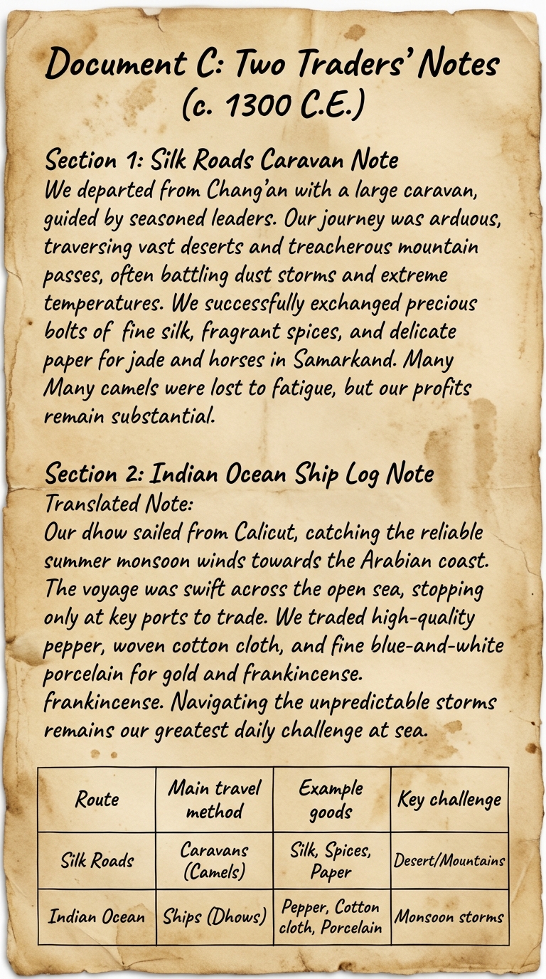
Document C includes two translated notes from about 1300 C.E.: one from a Silk Roads caravan trader and one from an Indian Ocean sailor. Each describes travel conditions and goods exchanged. Use the notes and the comparison table to compare how trade connected regions and spread products, people, and ideas.
Using evidence from both notes in Document C, explain one similarity and one difference between Silk Roads trade and Indian Ocean trade.
Include at least two specific details (goods, travel method, conditions, or ports).
Explain how the geography described in Document C helped shape what was traded and how traders traveled.
Use evidence from the document to support your answer.
Which comparison is best supported by evidence in Document C?
Which piece of information from Document C would be most useful for placing each trade network in its environmental context?
A student says, “These two networks connected people in the same way, so there is no reason to study both.”
Which claim best challenges the student using evidence from Document C?
Historical Document: Indian Ocean Sailing Directions (c. 1400 C.E.)

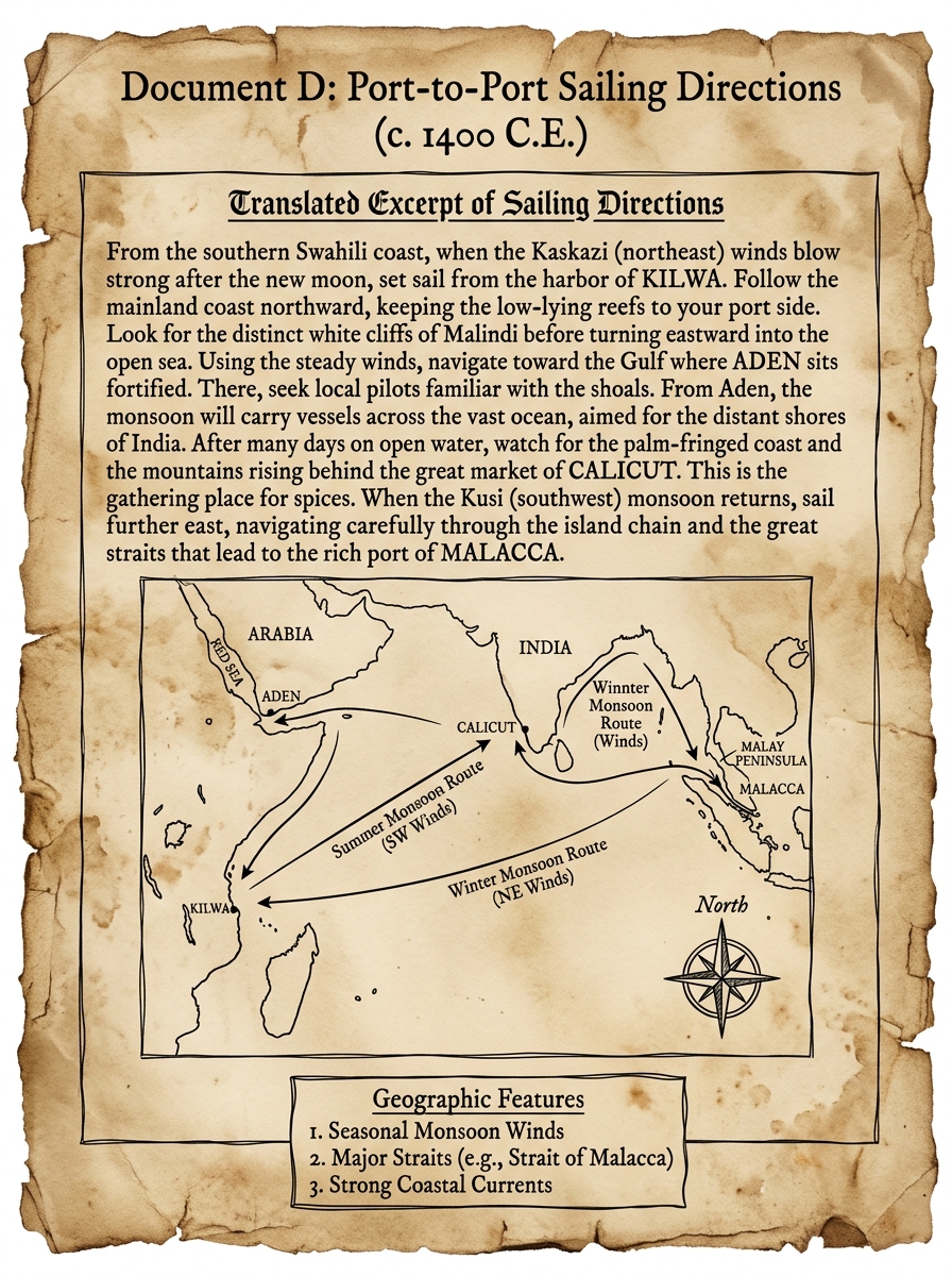
Document D is a translated excerpt from sailing directions written around 1400 C.E. It names ports along East Africa, Arabia, India, and Southeast Asia and explains how sailors used winds and coastal landmarks to plan routes. Use the map sketch and notes as evidence.
Which piece of evidence from Document D would be most useful for explaining how geography shaped where trade hubs developed?
Using Document D, explain how sailors used geographic information to reduce risk on Indian Ocean voyages.
Include at least two specific details (ports, winds, landmarks, or route arrows).
A student says, “Geography mattered less than politics for Indian Ocean trade.”
Use evidence from Document D to support or challenge this statement.
Which geographic feature in Document D most directly explains why sailors could travel in different directions at different times of year?
Based on the ports and arrows shown in Document D, which conclusion about Indian Ocean trade routes is best supported?
Historical Document: Merchant Account Book (c. 1350 C.E.)

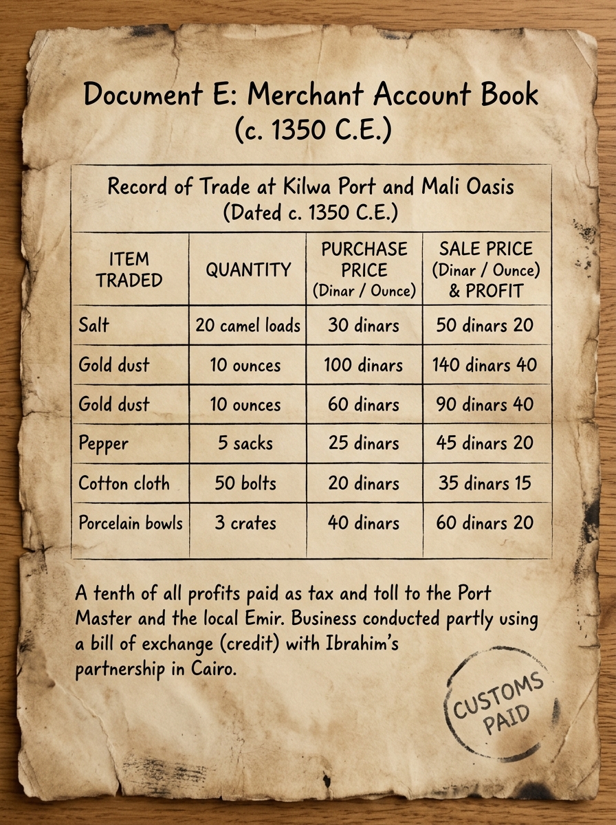
Document E is a translated page from a merchant’s account book dated about 1350 C.E. It records prices, costs, and profits for goods carried across Afro-Eurasian trade networks. It also notes payments to toll stations and port officials. Use the entries and totals as evidence.
Which type of economic decision is the merchant most clearly making in Document E?
Based on Document E, which conclusion about Afro-Eurasian trade networks is best supported?
Which piece of evidence from Document E best shows that trade involved extra costs beyond buying and selling goods?
Economic reasoning: Using Document E, explain how costs (such as tolls or customs) could affect a merchant’s profit and decisions about what to trade.
Use at least two specific details from the document.
Economic systems: What does Document E suggest about how trade networks connected different regions’ resources and demand?
Use evidence from the list of goods and the merchant’s records to support your answer.