Twa kɔ nsɛm atitiriw so
Log in
Sign up for FREE
arrow_back
Laabri

6.7c - Interactions Across The Eastern Hemisphere - Practices A through E

star
star
star
star
star
Last updated about 2 months ago
25 Nsɛmmisa
Hyɛ no nsow a efi ɔkyerɛwfo no hɔ:

Use the historical document(s) and the short readings in the left panel to answer the associated questions.

Use the historical document(s) and the short readings in the left panel to answer the associated questions.

6.7.c
DOK.SS.2
6.7.c
DOK.SS.2
6.7.c
DOK.SS.2
6.7.c
DOK.SS.2
6.7.c
DOK.SS.2
Ɛhia
1
6.7.c
DOK.SS.2
Ɛhia
1
6.7.c
DOK.SS.2
Ɛhia
2
6.7.c
DOK.SS.2
Ɛhia
1
6.7.c
DOK.SS.2
Ɛhia
2
6.7.c
DOK.SS.2
Ɛhia
1
6.7.c
DOK.SS.2
Ɛhia
2
6.7.c
DOK.SS.2
Ɛhia
2
6.7.c
DOK.SS.2
Ɛhia
1
6.7.c
DOK.SS.2
Ɛhia
1
6.7.c
DOK.SS.2
Ɛhia
1
6.7.c
DOK.SS.2
Ɛhia
1
6.7.c
DOK.SS.2
Ɛhia
1
6.7.c
DOK.SS.2
Ɛhia
2
6.7.c
DOK.SS.2
Ɛhia
2
6.7.c
DOK.SS.2
Ɛhia
1
6.7.c
DOK.SS.2
Ɛhia
2
6.7.c
DOK.SS.2
Ɛhia
1
6.7.c
DOK.SS.2
Ɛhia
2
6.7.c
DOK.SS.2
Ɛhia
1
6.7.c
DOK.SS.2
Ɛhia
1
6.7.c
DOK.SS.2
Ɛhia
1
6.7.c
DOK.SS.2
Ɛhia
2
6.7.c
DOK.SS.2
Ɛhia
1
6.7.c
DOK.SS.2
Ɛhia
2
6.7.c
DOK.SS.2

Historical Document: Ship Technology and Trade (c. 1400 C.E.)

This museum sketch of a Chinese junk ship shows multiple masts, a sternpost rudder, and interior partitions called watertight bulkheads. Merchants valued these features because they improved steering and reduced flooding, making long-distance sea travel safer for carrying heavy cargo across rough waters.
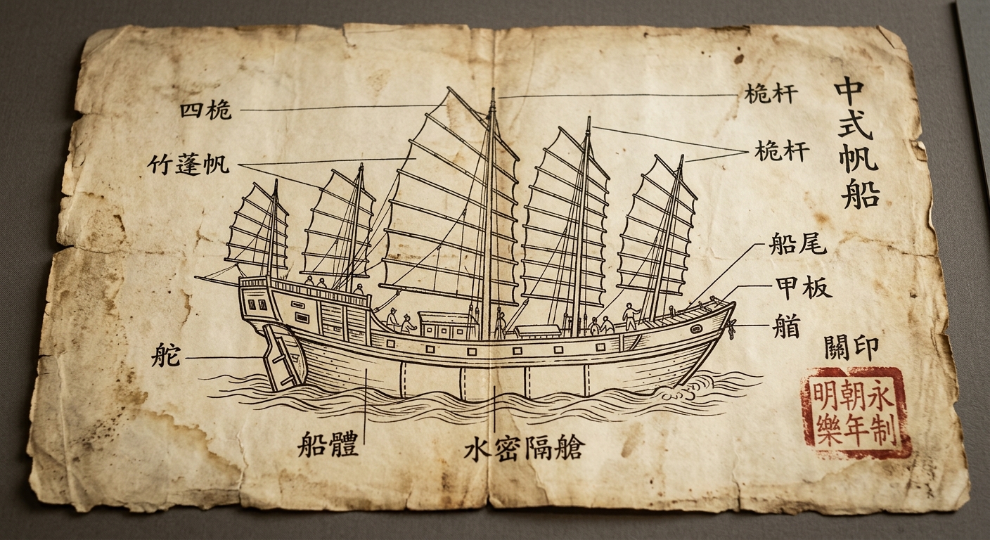
A parchment-style historical document with an ink drawing of a large Chinese junk ship, showing multiple masts and interior partitions, with a red seal stamp.

Asemmisa {{asɛmmisaAhyɛnsode}}
1.

Based on the reading stimulus, what problem would the sternpost rudder most directly help solve?

Asemmisa {{asɛmmisaAhyɛnsode}}
2.

Which conclusion is best supported by the document and reading stimulus about trade in the Eastern Hemisphere (c. 600–1450 C.E.)?

Asemmisa {{asɛmmisaAhyɛnsode}}
3.

A student claims, “Sea routes were always easier than land routes.”

Using evidence from this document, explain one reason sea travel could be advantageous for trade, and identify one limitation or risk that would still exist even with these technologies.

Asemmisa {{asɛmmisaAhyɛnsode}}
4.

Which detail from the document best supports the idea that this ship could protect goods during long voyages?

Asemmisa {{asɛmmisaAhyɛnsode}}
5.

Use evidence from the document and the reading stimulus to explain how at least two ship features helped societies move people and goods efficiently across challenging environments.

Cite the specific features you used as evidence.

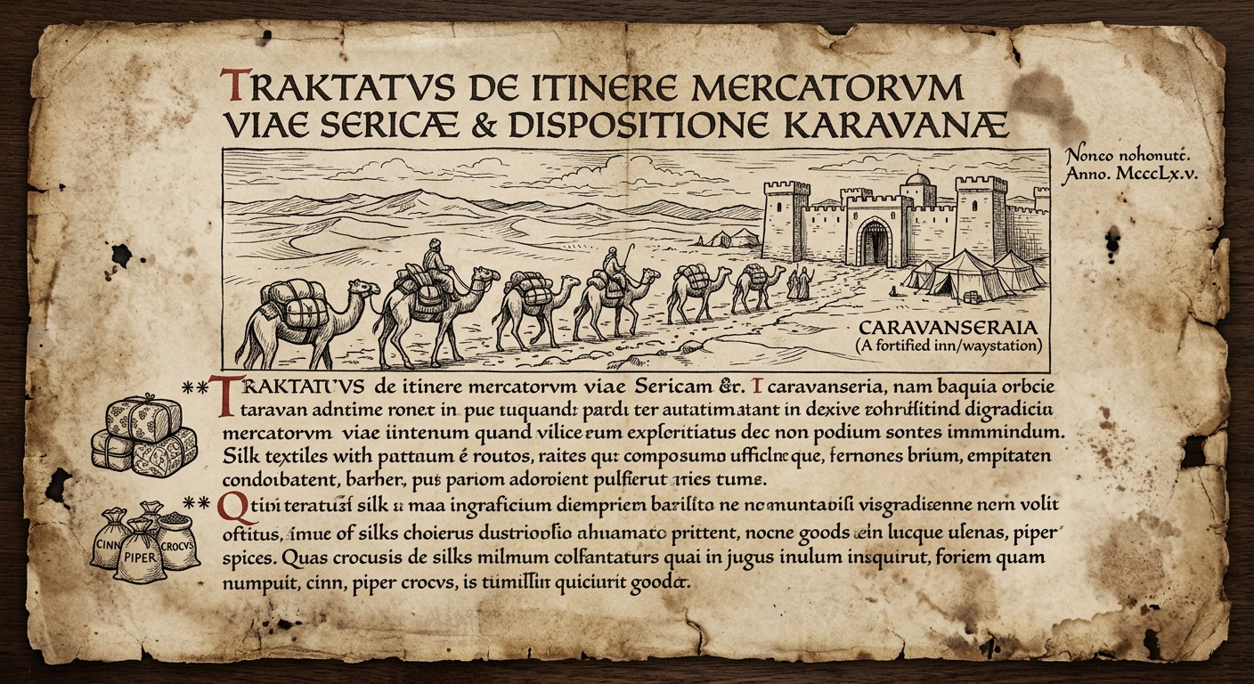
Historical Document: Caravan Travel and Trade (c. 1350 C.E.)

A merchant’s sketch from around 1350 C.E. shows a camel caravan traveling between desert waystations. Notes mark when travelers rest, refill water, and guard cargo. These supports helped merchants cross harsh terrain, keep goods organized, and reach markets on schedule.

Parchment-style historical document with an ink drawing of a camel caravan crossing a desert toward a caravanserai, with small trade-goods symbols.

Asemmisa {{asɛmmisaAhyɛnsode}}
6.

Which detail from the document best supports the idea that caravan travel depended on planned stops over time?

Asemmisa {{asɛmmisaAhyɛnsode}}
7.

Using evidence from the reading and the historical document, explain how a caravanserai (waystation) could change the chronology of a trade journey (what happens when), and why that mattered for moving goods efficiently.

Asemmisa {{asɛmmisaAhyɛnsode}}
8.

Some students think transportation technology only changes speed.

Using evidence from the sources, explain one way the caravan system changed the order of decisions or actions during travel, not just how fast the caravan moved.

Asemmisa {{asɛmmisaAhyɛnsode}}
9.

A historian argues that overland trade required managing time as well as distance. Which conclusion is best supported by the reading and image?

Asemmisa {{asɛmmisaAhyɛnsode}}
10.

Which sequence best represents the order of actions suggested by the reading for a caravan crossing a desert?

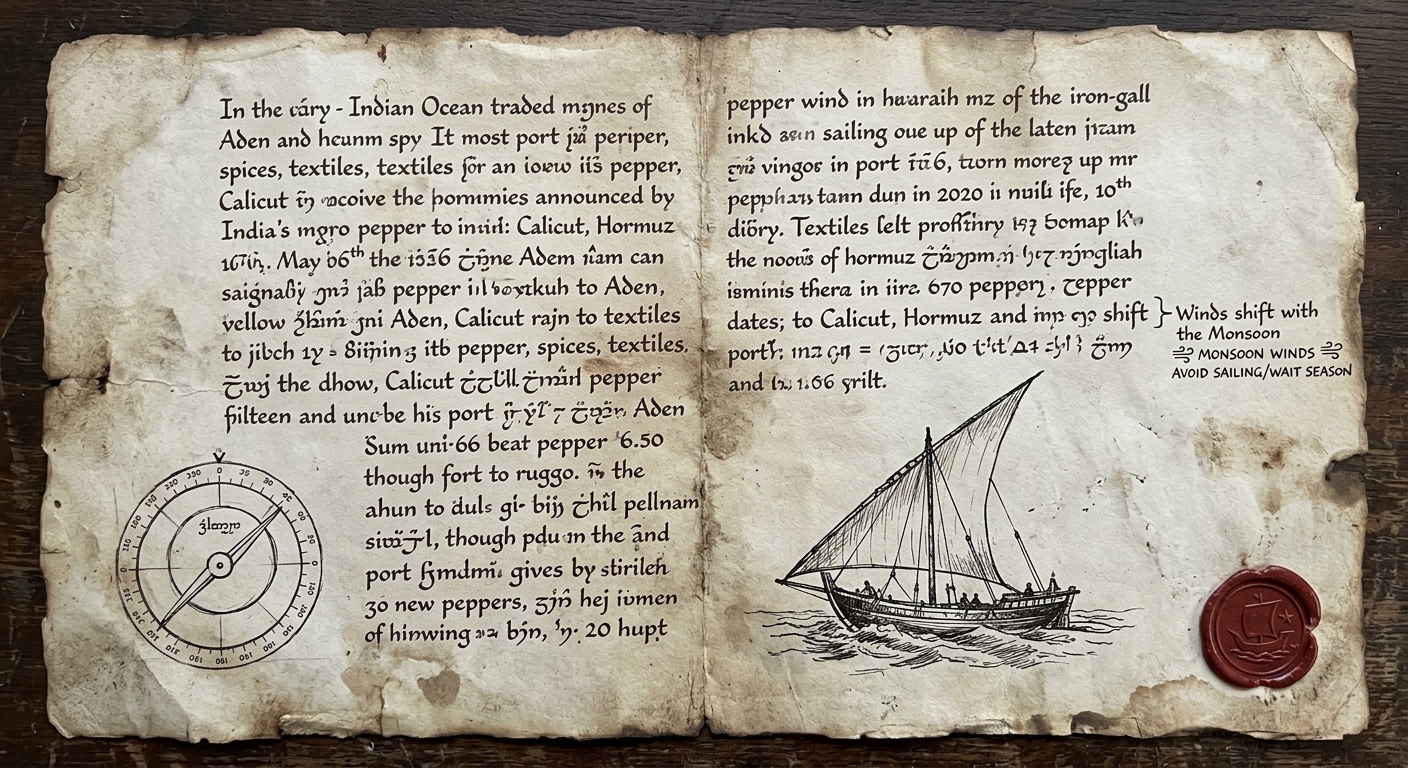
Historical Document: Indian Ocean Sailing Notes (c. 1100 C.E.)

A trader’s notebook page from about 1100 C.E. shows a dhow with a triangular lateen sail and a sketch of a navigation tool. A margin note mentions seasonal winds that determine when ships depart and return. These technologies helped sailors plan routes between coastal ports.

Parchment-style document with ink drawings of a dhow with a triangular sail and a simple navigation tool, with handwritten notes about seasonal winds.

Asemmisa {{asɛmmisaAhyɛnsode}}
11.

Which comparison is best supported by the reading when you compare Indian Ocean sea travel to desert caravan travel?

Asemmisa {{asɛmmisaAhyɛnsode}}
12.

In the context of Afro-Eurasian trade (c. 600–1450 C.E.), which conclusion is best supported by the document and reading?

Asemmisa {{asɛmmisaAhyɛnsode}}
13.

Which detail from the document best supports the idea that sailors adapted their ships to local wind conditions?

Asemmisa {{asɛmmisaAhyɛnsode}}
14.

Using evidence from the document and reading, explain how these technologies could affect interactions between coastal trading cities.

Asemmisa {{asɛmmisaAhyɛnsode}}
15.

Compare two challenges to trade travel—one for Indian Ocean routes and one for overland desert routes.

Using evidence from this document and what you know about overland caravans, explain how each transportation system responded to its challenge.

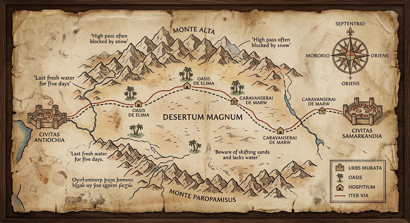
Historical Document: Trade Route Map with Waystations (c. 1300 C.E.)

A traveler’s map from about 1300 C.E. shows two overland routes linking inland cities. Mountains and deserts are drawn to highlight difficult terrain. Symbols mark oases and caravanserai where traders could rest, refill water, and protect goods. Such planning helped caravans cross harsh landscapes efficiently.

Parchment-style medieval map showing mountains and a desert with trade routes marked between cities, including oasis and caravanserai icons and a compass rose.

Asemmisa {{asɛmmisaAhyɛnsode}}
16.

Which conclusion is best supported by the document about the relationship between geography and transportation technology in Afro-Eurasian trade?

Asemmisa {{asɛmmisaAhyɛnsode}}
17.

The standard says societies designed transportation technologies to cross challenging landscapes.

Using evidence from this document, explain how at least one technology or support system (such as caravanserai or pack animals) helped move goods across a geographic barrier shown on the map.

Asemmisa {{asɛmmisaAhyɛnsode}}
18.

Based on the map and reading, which geographic condition would most directly explain why oases and caravanserai are spaced along the route?

Asemmisa {{asɛmmisaAhyɛnsode}}
19.

Using evidence from the map and reading, explain how geographic information could help a caravan decide where and when to stop during a journey.

Cite at least two map details (symbols or features).

Asemmisa {{asɛmmisaAhyɛnsode}}
20.

If traders wanted to reduce risk from high mountain passes, which route choice is most consistent with the map’s geographic information?

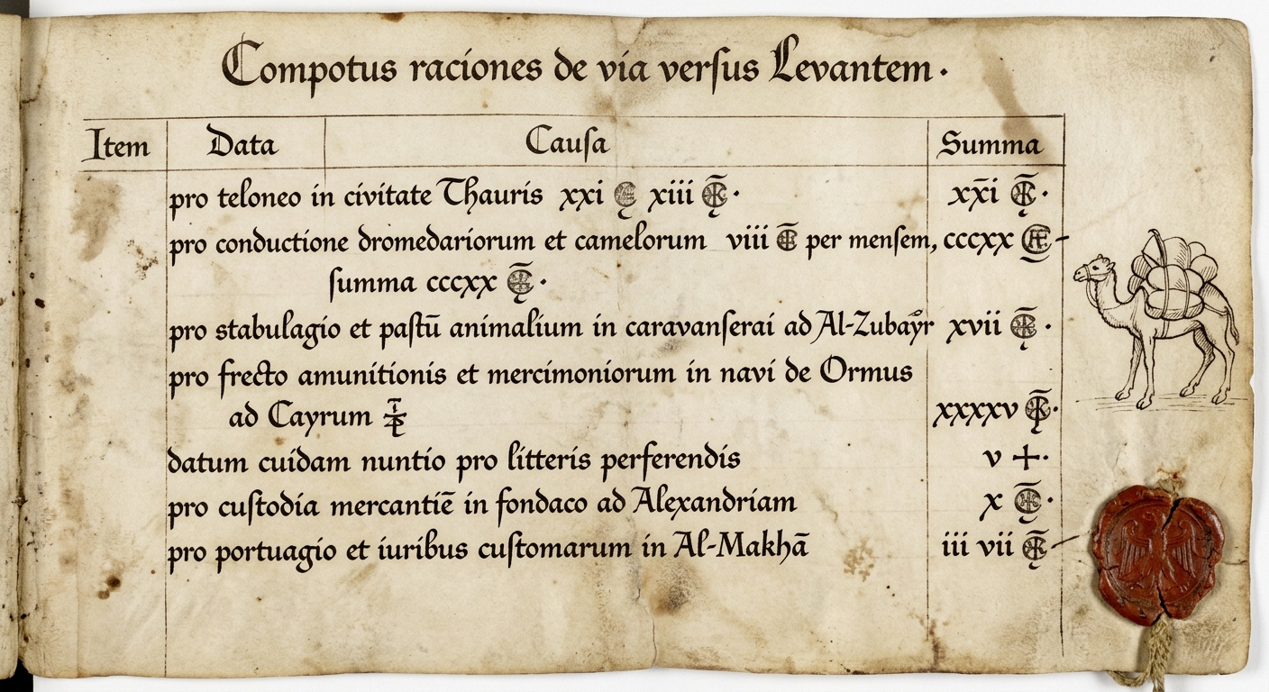
Historical Document: Merchant Ledger and Transport Costs (c. 1300 C.E.)

This ledger page records costs a merchant paid while moving goods across long-distance routes, including tolls, animal hire, and storage at a waystation. By tracking expenses, merchants judged whether a journey would be profitable. Transportation supports that reduced damage and delays could increase profit from trade.

A parchment-style merchant ledger page with handwritten cost entries for tolls and transport, plus a small sketch of a loaded camel.

Asemmisa {{asɛmmisaAhyɛnsode}}
21.

Based on the reading and document, which decision would a profit-seeking merchant be most likely to make?

Asemmisa {{asɛmmisaAhyɛnsode}}
22.

Which conclusion is best supported about how transportation supports (like waystations or reliable transport) affected economic activity in Afro-Eurasian trade?

Asemmisa {{asɛmmisaAhyɛnsode}}
23.

In an economic system, services can develop to support trade. Using evidence from the document and reading, explain how at least one service or technology (such as storage at a waystation, pack animals, or organized transport) helped move goods efficiently and shaped how merchants made money.

Asemmisa {{asɛmmisaAhyɛnsode}}
24.

Which piece of evidence from the ledger best supports the idea that long-distance trade involved ongoing costs, not just buying and selling goods?

Asemmisa {{asɛmmisaAhyɛnsode}}
25.

Using evidence from the ledger and reading, explain one economic trade-off a merchant faced when choosing a route (for example, higher fees vs. lower risk).

Explain how a transportation support system could change that trade-off.