Preskoči na glavni sadržaj
Prijava
Sign up for FREE
arrow_back
Biblioteka

8.7c - Foreign Policy: - Practices A through E

star
star
star
star
star
Posljednje ažuriranje 2 months ago
25
Napomena autora:

Use the historical document(s) and the short readings in the left panel to answer the associated questions.

Use the historical document(s) and the short readings in the left panel to answer the associated questions.

8.7.c
DOK.SS.2
8.7.c
DOK.SS.2
8.7.c
DOK.SS.2
8.7.c
DOK.SS.2
8.7.c
DOK.SS.2
Obavezno
1
8.7.c
DOK.SS.2
Obavezno
2
8.7.c
DOK.SS.2
Obavezno
1
8.7.c
DOK.SS.2
Obavezno
1
8.7.c
DOK.SS.2
Obavezno
2
8.7.c
DOK.SS.2
Obavezno
1
8.7.c
DOK.SS.2
Obavezno
2
8.7.c
DOK.SS.2
Obavezno
1
8.7.c
DOK.SS.2
Obavezno
1
8.7.c
DOK.SS.2
Obavezno
2
8.7.c
DOK.SS.2
Obavezno
1
8.7.c
DOK.SS.2
Obavezno
1
8.7.c
DOK.SS.2
Obavezno
1
8.7.c
DOK.SS.2
Obavezno
2
8.7.c
DOK.SS.2
Obavezno
2
8.7.c
DOK.SS.2
Obavezno
1
8.7.c
DOK.SS.2
Obavezno
1
8.7.c
DOK.SS.2
Obavezno
1
8.7.c
DOK.SS.2
Obavezno
2
8.7.c
DOK.SS.2
Obavezno
2
8.7.c
DOK.SS.2
Obavezno
1
8.7.c
DOK.SS.2
Obavezno
1
8.7.c
DOK.SS.2
Obavezno
2
8.7.c
DOK.SS.2
Obavezno
2
8.7.c
DOK.SS.2
Obavezno
1
8.7.c
DOK.SS.2

Historical Document:
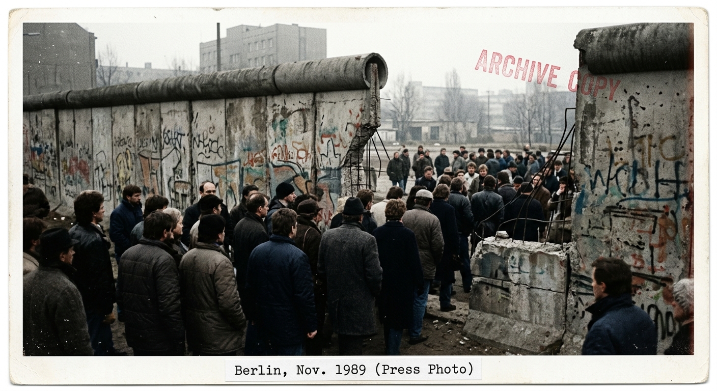
Fictional 1989 press-photo style image showing people gathered at an opening near the Berlin Wall by a checkpoint, suggesting the Cold War’s end.

As the Cold War ended, U.S. officials reassessed alliances and military commitments in Europe. Images of opened borders symbolized rapid political change, but new conflicts soon demanded attention elsewhere. Use the document to gather evidence about borders, movement, and security concerns in U.S. foreign policy.
Pitanje 1
1.

Based on the document and reading, which inference is most reasonable about why geography mattered to U.S. policy as the Cold War ended?

Pitanje 2
2.

Use evidence from BOTH the reading and the document to explain one continuity and one change in U.S. foreign policy concerns after the Cold War.

Your answer must include at least one geographic reference (borders, movement, or location).

Pitanje 3
3.

Which claim is best supported by evidence you can gather from the document?

Pitanje 4
4.

Which piece of evidence from the historical document best supports the idea that a political boundary was becoming more open?

Pitanje 5
5.

Using evidence you can observe in the document, describe two features that indicate the importance of borders or checkpoints.

Explain what each feature suggests about movement and security.

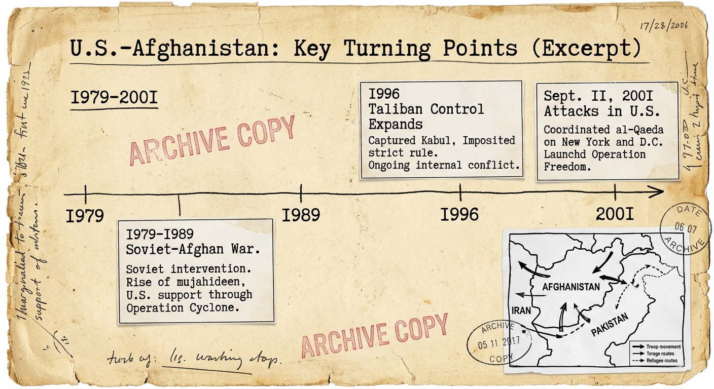
Historical Document:

Fictional archive-style document showing a timeline of key turning points in U.S.–Afghanistan relations from 1979 to 2001 with a small map inset of Afghanistan and neighboring countries.

During the late Cold War, the United States became involved in Afghanistan as the Soviet Union fought a long war there. After the Soviet withdrawal, new groups gained power, and U.S. attention shifted. This timeline and map help track how concerns changed over time.

Pitanje 6
6.

According to the timeline, which statement best describes the chronological relationship between the Soviet withdrawal and the expansion of Taliban control?

Pitanje 7
7.

Using evidence you can gather from the timeline and map inset, explain how chronology can help historians avoid oversimplifying causes of U.S. foreign policy actions after the Cold War.

Pitanje 8
8.

Which event happens last in the timeline?

Pitanje 9
9.

Which piece of evidence from the document best supports the idea that U.S. foreign policy concerns shifted from Cold War rivalry to new security threats?

Pitanje 10
10.

Use evidence from BOTH the reading and the document to explain one continuity and one change in U.S. foreign policy related to Afghanistan from 1979 to 2001.

Your response must refer to at least two points on the timeline.

Historical Document:

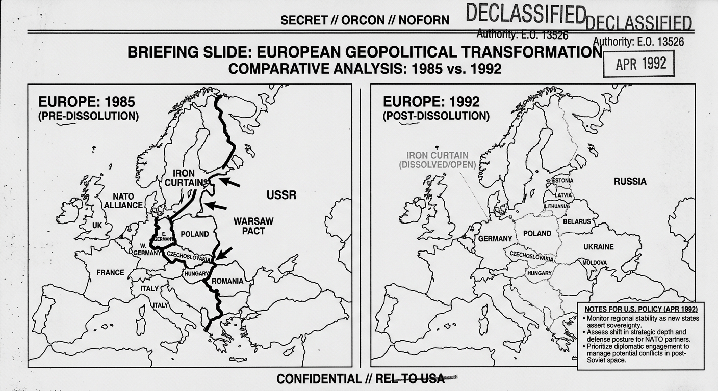
Fictional 1992 declassified-style briefing page with two side-by-side maps of Europe labeled 1985 and 1992 showing changes to Cold War boundaries and country outlines.

After 1990, U.S. officials compared Cold War and post–Cold War maps to interpret what had changed—and what had not. The goal was to understand how older alliance patterns and new borders could reshape security decisions. Use the document to compare contexts across time.

Pitanje 11
11.

Which comparison is best supported by evidence in the two maps?

Pitanje 12
12.

Which statement best contextualizes why U.S. policymakers would compare a 1985 map to a 1992 map?

Pitanje 13
13.

Which claim is most supported by combining evidence from the reading and the two-map document?

Pitanje 14
14.

Use evidence from the two maps to describe one major difference between the 1985 context and the 1992 context in Europe.

Explain why that difference could matter for U.S. foreign policy.

Pitanje 15
15.

Contextualize the 1992 map by explaining how one legacy of the Cold War could still influence U.S. decisions in Europe after 1990.

Use at least one piece of evidence from the maps and one idea from the reading.

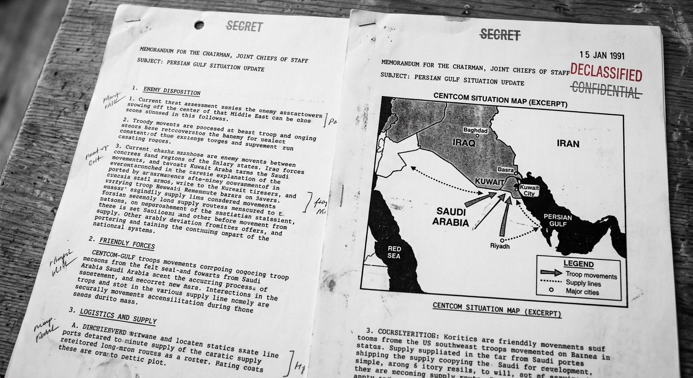
Historical Document:

Fictional declassified-style briefing page with a black-and-white map of the Persian Gulf region labeled Iraq, Kuwait, Saudi Arabia, and Iran, showing arrows for troop movements and supply lines, dated January 1991.

After the Cold War, U.S. leaders debated how to respond to regional conflicts. In 1990–1991, Iraq’s invasion of Kuwait raised concerns about borders, oil access, and shipping routes in the Persian Gulf. The map shows locations U.S. planners considered when forming a coalition.

Pitanje 16
16.

Which geographic factor best helps explain why many countries viewed the 1990 invasion of Kuwait as a global concern?

Pitanje 17
17.

Which statement is best supported by the document map?

Pitanje 18
18.

Based on the map, which country is most likely to serve as a key staging area for coalition forces because it borders the conflict area and has access to the Persian Gulf?

Pitanje 19
19.

Using evidence from BOTH the reading and the map, explain two ways geography shaped U.S. and coalition decision-making in the 1990–1991 Gulf crisis.

Pitanje 20
20.

Explain one continuity (legacy) from Cold War foreign policy and one change after the Cold War that are suggested by this document.

Use geographic evidence from the map or reading in your response.

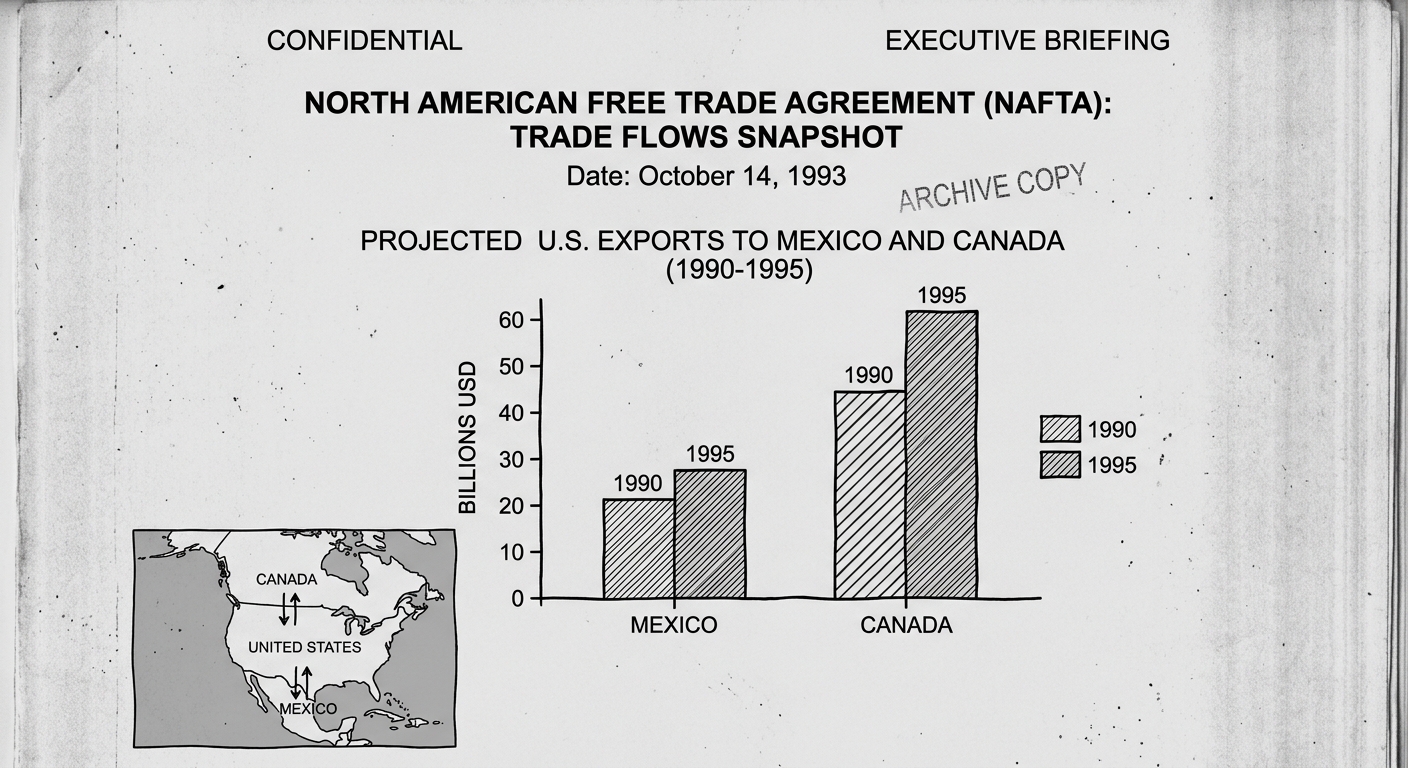
Historical Document:

Fictional 1993 briefing page with a bar chart of U.S. exports to Canada and Mexico and a small North America map with arrows showing trade flows, labeled NAFTA trade snapshot.

After the Cold War, U.S. foreign policy increasingly included economic goals. Agreements such as NAFTA aimed to reduce trade barriers and strengthen ties in the Western Hemisphere. This document combines a map and trade data to show how economic interdependence can shape relationships between countries.

Pitanje 21
21.

Based on the bar chart, which inference is most reasonable about economic interdependence among the United States, Canada, and Mexico?

Pitanje 22
22.

Which evidence from the document best supports the idea that geography can affect economic policy decisions?

Pitanje 23
23.

Explain how this document can be used to contextualize the United States’ role in global affairs after the Cold War.

Your response must reference one piece of economic evidence and one idea about foreign policy change.

Pitanje 24
24.

Using evidence from BOTH the reading and the document, explain one benefit and one potential drawback of increased economic interdependence for the United States in the post–Cold War era.

Pitanje 25
25.

Which statement best describes an economic goal suggested by the reading and document?