NOTICE … A four-function or scientific calculator and a copy of the 2024 Edition Reference Tables for Earth and Space Sciences must be available for you to use while taking this examination. Note that diagrams are not drawn to scale unless otherwise noted.
2024 Edition Reference Tables for Earth and Space Sciences: https://www.nysed.gov/sites/default/files/programs/state-assessment/earth_space_science_ref_tables_2024.pdf
NOTICE … A four-function or scientific calculator and a copy of the 2024 Edition Reference Tables for Earth and Space Sciences must be available for you to use while taking this examination. Note that diagrams are not drawn to scale unless otherwise noted.
2024 Edition Reference Tables for Earth and Space Sciences: https://www.nysed.gov/sites/default/files/programs/state-assessment/earth_space_science_ref_tables_2024.pdf
Base your answers to questions 1 through 4 on the information below and on your knowledge of Earth and Space Sciences. Some questions may require the use of the 2024 Edition Reference Tables for Earth and Space Sciences.
Iceland Hotspot
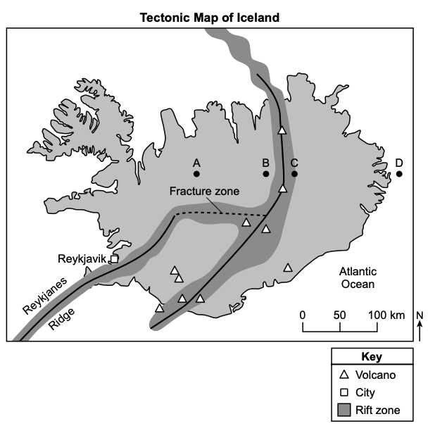
Iceland is one of the most active volcanic regions on Earth. It is a hotspot in the north Atlantic Ocean near the Reykjanes Ridge. The island formed by a combination of seafloor spreading and volcanism.
The map below shows some information about the tectonic setting of Iceland. Points A through D represent locations on Earth’s surface.

Place the letters representing locations
(youngest)

(oldest)
Base your answers to questions 5 through 8 on the information below and on your knowledge of Earth and Space Sciences. Some questions may require the use of the 2024 Edition Reference Tables for Earth and Space Sciences.
Stars and Stellar Evolution
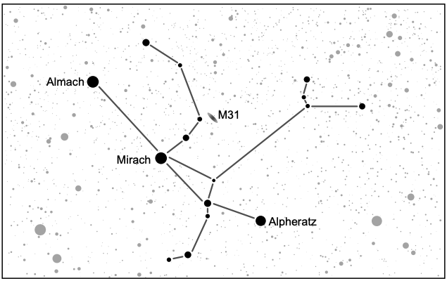
The Andromeda constellation contains several stars including three of the brightest stars in the sky: Almach, Mirach, and Alpheratz. Almach is a multiple-star system located 350 light years (ly) from Earth. A light year is defined as the distance that light travels in one year, about 6 trillion miles or
The Andromeda Galaxy, known as M31, is also within the Andromeda constellation. It is 2.5 million ly away from Earth.
The Andromeda constellation is visible in both the northern and southern hemispheres of Earth, but is not visible at latitudes greater than
The model below shows some information about a constellation.
Model of the Andromeda Constellation
(Not drawn to scale)
Base your answers to questions 9 through 13 on the information below and on your knowledge of Earth and Space Sciences. Some questions may require the use of the 2024 Edition Reference Tables for Earth and Space Sciences.
The slow carbon cycle is controlled by various geologic processes that move carbon between Earth’s spheres. Carbon takes millions of years to move between rocks, soil, the ocean, and the atmosphere through a series of chemical reactions.
The movement of carbon from the atmosphere into rocks begins when atmospheric carbon (
Carbon dioxide can be returned to the atmosphere through crustal plate movement and volcanic activity.
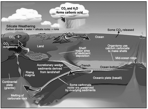
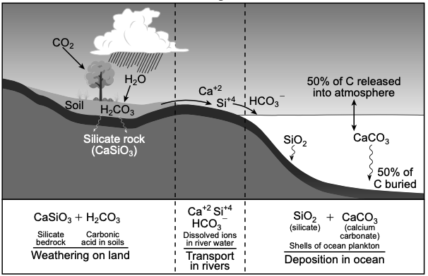
The models below show some information about how silicate rocks are weathered to produce carbonate rocks that cycle carbon among Earth’s spheres.
How Silicate Rocks are Transformed into Carbonate Rocks Model
(Not drawn to scale)
Model of Chemical Weathering of Silicate Rocks on Earth
(not drawn to scale)
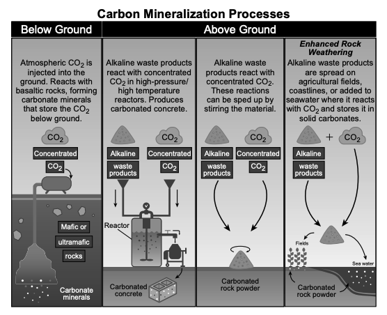
Scientists are developing solutions to reduce atmospheric carbon dioxide (CO

Base your answers to questions 14 through 18 on the information below and on your knowledge of Earth and Space Sciences. Some questions may require the use of the 2024 Edition Reference Tables for Earth and Space Sciences.
Conditions of a Polar Vortex Event
A polar vortex is a large area of low pressure and cold air surrounding the North Pole. When the polar vortex is especially strong, the polar jet stream stays farther north. The polar jet stream is a fast-moving belt of westerly winds in the atmosphere. The polar vortex keeps the cold air contained over the Arctic. When the polar vortex weakens, it can cause the polar jet stream to change. A notable polar vortex occurred in January 2014.
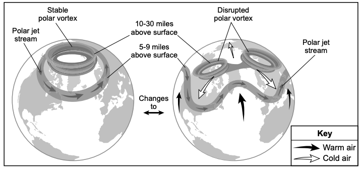
The model below represents conditions of the polar vortex that determine the extent of the polar jet stream affecting the Northern Hemisphere during winter.
Model of Polar Vortex Conditions
(Not drawn to scale)
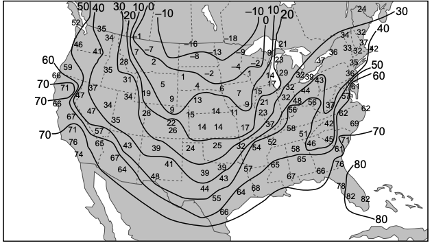
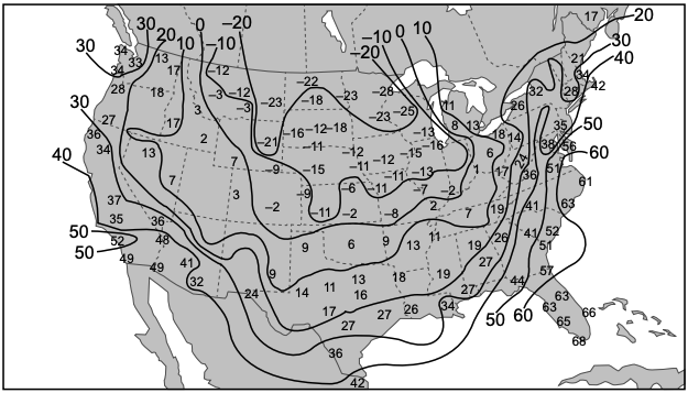
The weather maps below show the maximum and minimum temperatures (°F) for January 6, 2014, when the United States was experiencing a polar vortex event.
Maximum Temperatures: Monday, January 6, 2014

Minimum Temperatures: Monday, January 6, 2014

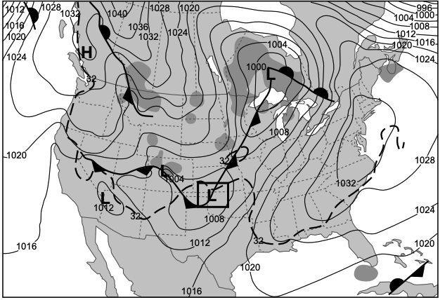
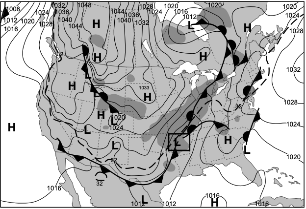
The maps below show weather information for January 4, 2014 and January 5, 2014. The dashed line indicates the 32°F isotherm at 7 a.m. eastern standard time on each day. Areas of precipitation are shown in dark gray.
Saturday, January 4, 2014 Weather Map

Sunday, January 5, 2014 Weather Map

Complete the model below by placing the names of all three stars in order of their relative ages. Then, label their correct H-R Diagram classification.
Relative age
(youngest) 1.
2.
3.
Classification
1.
2.
3.
Base your answers to questions 24 through 27 on the information below and on your knowledge of Earth and Space Sciences. Some questions may require the use of the 2024 Edition Reference Tables for Earth and Space Sciences.
The Influence of Volcanoes on Earth’s Systems
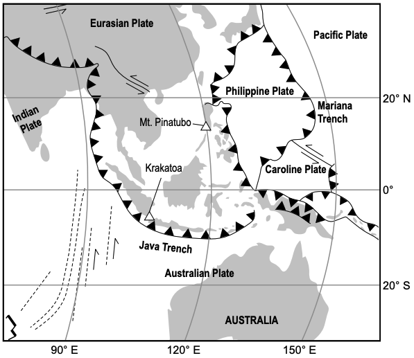
Two of Earth’s major volcanic eruptions occurred in 1883 at Krakatoa in Indonesia and in 1991 at Mt. Pinatubo in the Philippines. Both of these major eruptions produced large plumes of rock, ash, and gases that extended upward into Earth’s stratosphere. Global winds circulated the ash and gases around Earth producing impacts for years. The model below shows some information about the tectonic setting of Southeast Asia.
Model of Plate Motions in Southeast Asia

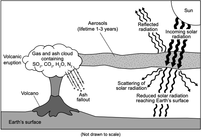
Volcanic eruptions cause changes to several Earth systems. The model below shows the effects that large volcanic eruptions, like those that occurred at Krakatoa and Mt. Pinatubo, have on the atmosphere. Very small solid or liquid particles (aerosols) ejected from volcanoes become suspended.
Volcanic Eruption Model

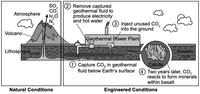
Although volcanic activity can cause problems for humans, it can also provide benefits. The model below shows a four-step process of converting geothermal energy into usable energy, which includes mitigation of a cause of climate change.
Model of Geothermal Power Plant with Mitigation Components
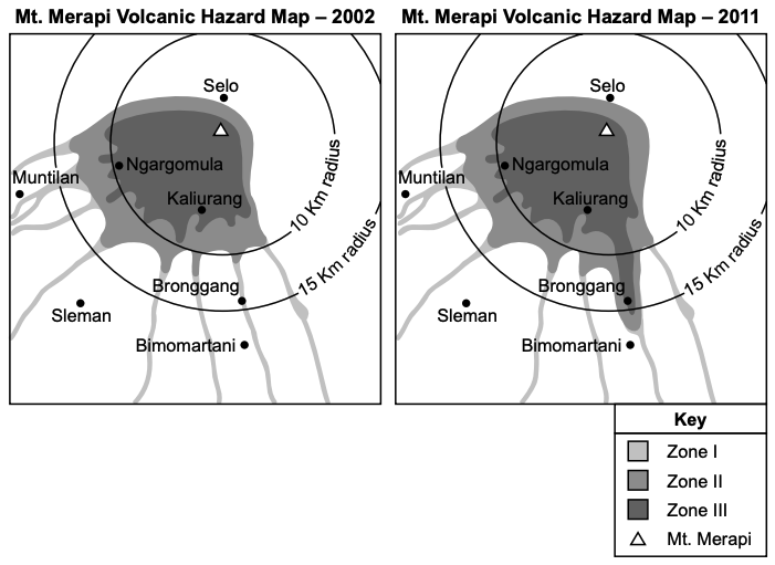
The Mount Merapi volcano hazard maps were made to identify areas of potential impact from pyroclastic flows as a result of previous eruptions. Locations in Zone I have a lower probability of being impacted by a pyroclastic flow (fast-moving hot ash and gas), while areas in Zone III have the highest probability of being impacted by pyroclastic flows.

Use information from the Volcanic Eruption Model to describe how aerosols ejected from volcanoes affect energy flow into and out of Earth’s system. Also, describe the change in climate in the years following volcanic eruptions that most likely results from this change in energy flow.
Effect of aerosols on energy flow:
Change in climate:
Base your answers to questions 28 through 31 on the information below and on your knowledge of Earth and Space Sciences. Some questions may require the use of the 2024 Edition Reference Tables for Earth and Space Sciences.
The production of concrete starts by mixing limestone and clay together, which are heated and dried in a kiln to produce clinker. Clinker is then pulverized into a fine powder and mixed with gypsum to make Portland cement. Aggregates, such as crushed stone and sand, are added to the Portland cement along with water to make a new product called concrete.
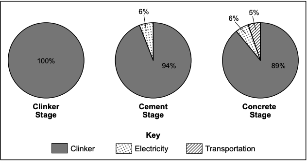
The pie charts below show some information about the carbon footprint of the three stages of concrete production. Carbon footprint is the percent of carbon emissions generated at each stage.
Carbon Footprint of Each Stage of Concrete Production
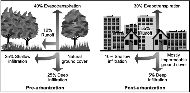
Concrete has been used for centuries in the development of urban areas. The model below shows some information about urbanization.
Urbanization Impact on Earth's Spheres
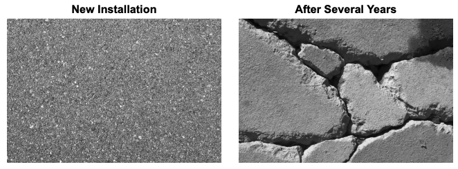
Engineers have developed a newer type of concrete, called porous concrete, to address some environmental issues that accompany urbanization. An investigation was completed by an engineer in northern New York using the properties of water to determine water’s impact on porous concrete. The tables below show some information on the properties of concrete and water. The photographs show the results of the engineer’s investigation.
Porosity
Concrete Type | Open Space (%) |
|---|---|
Traditional | 3–5 |
Porous | 15–22 |
Properties of Water
Phase | Temperature ( | Density (g/mL) |
|---|---|---|
Liquid | 4 | 1.0 |
Solid | 0 | 0.92 |
Porous Concrete
The six factual statements below describe some considerations for the use of porous concrete throughout New York State.
I — Sand cannot be used on new porous concrete for ice control.
II — Porous concrete typically has a cooler surface temperature during the summer.
III — Porous concrete has a higher cost for installation and maintenance.
IV — Porous concrete cannot be used for roads, bridges, dams, and buildings.
V — Porous concrete filters sediments from runoff.
VI — Porous concrete has a rougher surface and provides better traction during the winter.
Base your answers to questions 32 through 36 on the information below and on your knowledge of Earth and Space Sciences. Some questions may require the use of the 2024 Edition Reference Tables for Earth and Space Sciences.
Lake Nyos
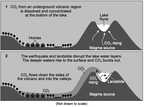
Lake Nyos sits in the crater of an inactive volcano in northwestern Cameroon, Africa, within the Oku Volcanic Field. Lake Nyos has almost no convection. A layer of warm water always sits on top of a deep layer of cold water. In 1986, a large bubble of carbon dioxide that was trapped at the bottom of the lake rose to the surface. The carbon dioxide then moved down into the valley killing 1800 people and 3500 livestock.
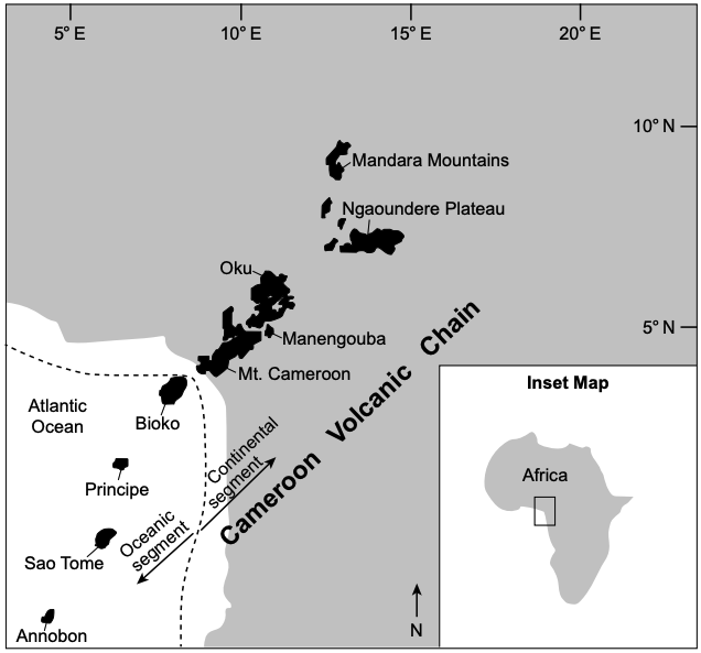
The map below shows the locations and names of the volcanic features that include Lake Nyos. The inset map shows the location of the Cameroon Volcanic Chain in Africa.
Map of Cameroon Volcanic Chain

The infographic below shows some information about the Lake Nyos event.
Process of Carbon Dioxide Emission in Lake Nyos

The magma creating the Cameroon Volcanic Chain is rich in carbon dioxide. Two sources of carbon dioxide in the magma are found in surface and mantle minerals and rocks. Carbonate minerals and rocks (containing carbon and oxygen) located on Earth are broken down and melted.
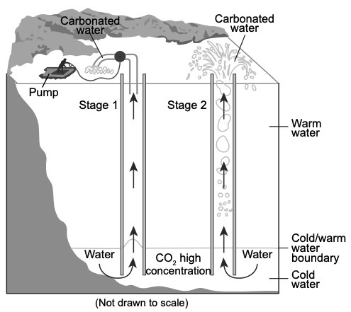
After several studies in the 1980s and early 1990s, scientists and engineers proposed installing degassing pipes in Lake Nyos to prevent further loss of life. These pipes function in two stages. In stage one, carbon dioxide would be removed by using a powered pump to pull small amounts of cold water from the bottom of the lake to the surface.
In stage two, the bubbling from the carbon dioxide coming out of the water (carbonated water) creates suction and makes the process self-sustaining. The first degassing pipe was installed in 2001 with additional pipes installed in 2011. The carbon dioxide now comes to the surface under its own pressure with no pump required.
Degassing Pipes Model

Base your answers to questions 37 through 41 on the information below and on your knowledge of Earth and Space Sciences. Some questions may require the use of the 2024 Edition Reference Tables for Earth and Space Sciences.
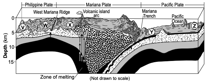
The Mariana Plate is a microplate that is located west of the Mariana Trench. Geologic activity caused a section of the Philippine Plate to break off and become the Mariana Plate. This microplate is surrounded by many geologic features and complex plate boundaries. Letters V through Z represent locations on Earth’s surface.
Model of Area Surrounding the Mariana Trench

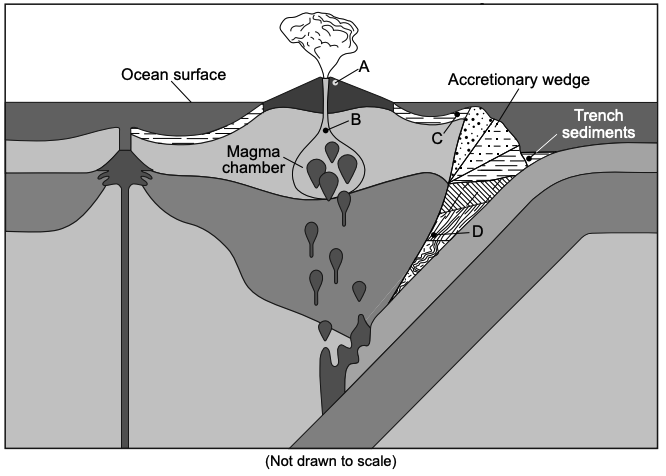
The model below shows some information about rock formation in the area surrounding the Mariana microplate.
Model of Rock Formation Environments Along Plate Boundary

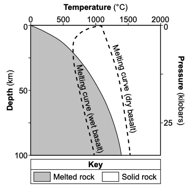
At the Mariana trench, water-bearing minerals are brought into the mantle, altering the melting point temperature. The graph below shows some information about melting of basalt. Pressures on the graph are in kilobars (one kilobar is equivalent to one thousand times Earth’s average surface air pressure).
Melting Curves for Wet and Dry Basalt

Name one tectonic feature that forms in an area above melting oceanic crust. Then use evidence from the graph to describe how the presence of water affects the melting point of basalt.
Tectonic feature:
Evidence:
Describe the two characteristics of the Kepler-16 stars compared to our Sun. Then, describe how these characteristics affect the lifetime of these stars compared to our Sun.
Characteristics:
Lifetime:
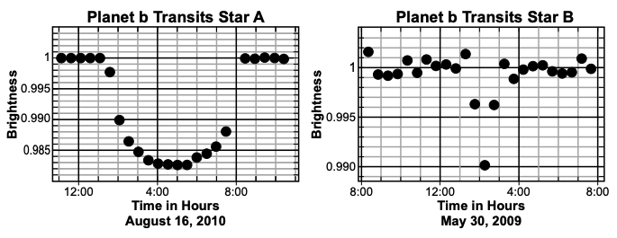
Calculate how long it takes planet Kepler-16b to transit both stars, and provide one reason why the planet’s transit takes a longer period of time to cross the star Kepler-16A compared to the star Kepler-16B.
Transit time for Kepler-16A:
Transit time for Kepler-16B:
Reason:
Base your answers to questions 47 through 50 on the information below and on your knowledge of Earth and Space Sciences. Some questions may require the use of the 2024 Edition Reference Tables for Earth and Space Sciences.
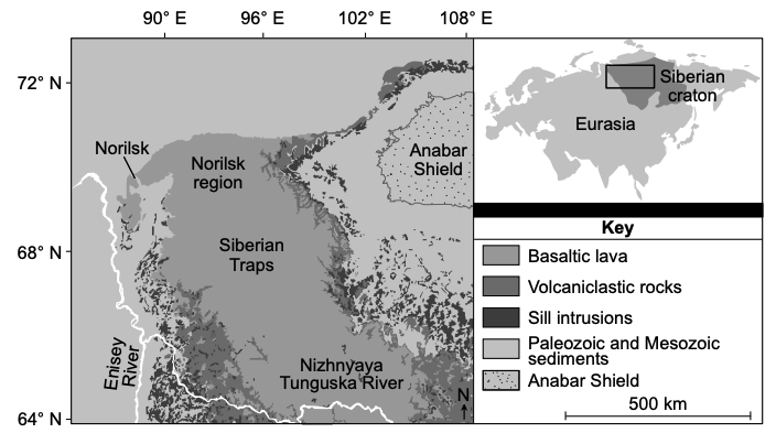
The Siberian Traps are one of the largest igneous features on Earth. The Siberian Traps did not form at a plate boundary or hotspot. Rising magma spread horizontally below the boundary of the crust and upper mantle. This formed a mushroom-shaped mantle plume. Magma pulses, lasting about 10,000 years each, erupted over a period of about one million years. The main volcanic pulse occurred about 252 million years ago. It is estimated that four million cubic kilometers of magma erupted to form the three-kilometer-thick structure. The Siberian craton includes the Anabar shield, which is the oldest original bedrock in the region.
The map below shows some information about the location and rock types associated with the Siberian Traps.
Siberian Trap Rock Types

Norilsk, Russia, is a mining town on the western edge of the Siberian Traps. Norilsk has large deposits of nickel-bearing ore. Processing this ore releases the pollutant sulfur dioxide. Sulfur dioxide causes breathing issues from the creation of aerosols, which are small particles in the atmosphere that reflect sunlight. Worldwide, Russia ranks number three in nickel production and number one in sulfur dioxide emissions.
Develop the model in the "Show Your Work" space that indicates how the Siberian Traps were formed. Your model must include a minimum of two arrows to represent the movement of magma within the magma plume.
Which statement correctly compares the rate of seafloor spreading at the ridge in Iceland to the rate of seafloor spreading at another plate boundary?
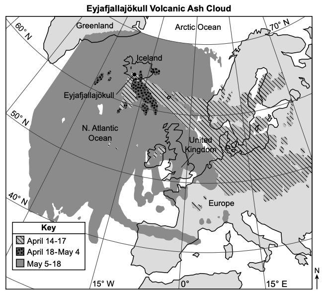
Which statement, based on evidence found on the map, describes how the movement of the Eyjafjallajökull ash cloud influenced humans?
Managing and mitigating lava flows from volcanic eruptions is a challenge due to the intense heat and fluid dynamics of lava. In Iceland, several solutions have been applied or proposed to address the impacts of lava flows.
The table below lists different methods that all require equipment to address the impact of lava flows on communities.
Possible Lava Flow Solutions
Solution | Description | Constraint | |
|---|---|---|---|
A | Lava diversion | Construct channels to redirect lava | – Costly – Time-consuming – Lava may breach – Redirects flows instead of stopping them |
B | Seawater cooling | Use pumps to draw seawater to spray lava to cool and harden | – Need constant water supply – Demand for energy to run multiple costly pumps |
C | Lava flow barrier | Build earthen barriers to dam the lava and stop its flow | – Need machinery/equipment to build barrier – Lava could breach the barrier |
D | Explosions | Detonate explosives to disrupt the lava flow and redirect its path | – Could cause further damage and loss of life – Not precise and lava returns to its original path |
Which proposed solution would best protect an Icelandic community from a lava flow when considering constraints such as costs and equipment?
Which row correctly lists the factors that influence nuclear reactions in stars and lists the types of elements in the core of some of the stars named in the Andromeda constellation?
Row | Factors That Influence Nuclear Reactions in Stars | Elements of Giant Stars in Andromeda |
|---|---|---|
1 | -Mass of star -Stage in lifetime | He and C |
2 | -Brightness of star -Stage in lifetime | H and He |
3 | -Mass of star -Distance from Earth | He and C |
4 | -Brightness of star -Distance from Earth | H and He |
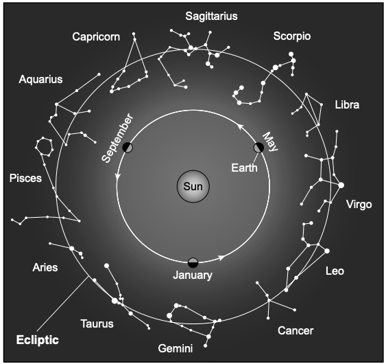
Identify the name and motion of the celestial object shown in the model that is responsible for the pattern of different constellations that are visible to an observer in the northern hemisphere. Then, identify the name of one constellation that would most likely be highest in the night sky at the same time that the Andromeda constellation would also be visible in the night sky at midnight in January in New York State.
Name and description of motion:
Constellation name:
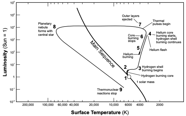
The graph below shows the evolution of a Sun-like star. Numbers 1 through 9 represent the steps in the sequence of a star’s evolution and its position on a H-R Diagram. Luminosity is the total amount of energy radiated by a star, compared to our Sun. The term “burning” refers to fusion.
Evolution of a Sun-like Star

Which piece of evidence in the Evolution of a Sun-like Star graph could be used to support the claim that nuclear fusion is the process responsible for energy generation in stars like our Sun and Mirach?
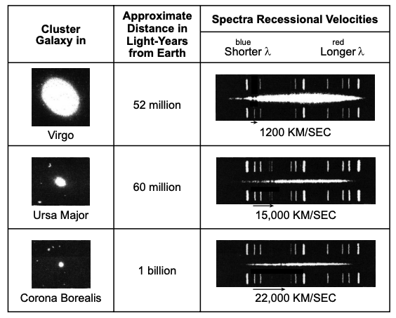
In 1924, Edwin Hubble studied the Andromeda Galaxy, along with many other galaxies, and found that there is a pattern in the speeds that galaxies are receding from Earth. Hubble’s finding had important implications for theories related to understanding the universe.
The table below shows some information about galaxies, including their distances and recessional velocities (speed relative to Earth). Black arrows below the spectra indicate how far the two darkest absorption lines have shifted in wavelength (

Four statements about the universe, labeled
A | The farther away a galaxy is from Earth, the more light is red-shifted, indicating an accelerating galaxy velocity. |
B | The greater the distance a galaxy is from Earth, the more recessional velocities decrease (along with blue-shifted spectra data). |
C | The closer galaxies are to Earth, the recessional velocity decreases, indicating the presence of cosmic microwave background radiation. |
D | As distance of galaxies increases from Earth, the recessional velocity increases, shifting spectra to include longer wavelengths. |
Which pair of statements supports the Big Bang theory, based on the given astronomical evidence of light spectra, galaxy distances, and galaxy velocities?
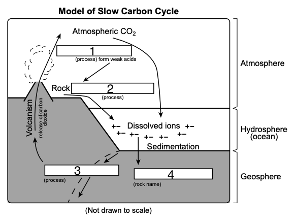
Complete the model by selecting the correct terms, from the choices provided, for the numbered boxes to describe the cycling of carbon between three Earth spheres. Not all terms will be used.

Box 1:
Box 2:
Box 3:
Box 4:
Describe how plate convergence cycles carbon in carbonate rocks by thermal convection from the lithosphere to the atmosphere.
Which statement identifies how the silicate rocks that have been chemically changed by water produced carbonate rocks in Earth’s oceans?
Based on the models, which table correctly identifies the processes that form carbonate rock from silicates and the distribution of these materials?
A student made claims about the four carbon mineralization processes. Which claim correctly evaluates a solution and describes how that solution reduces impacts of human activities on a natural system?
Describe how the pattern of movement of the polar jet stream changed when the polar vortex changed from stable to disrupted. Also, describe how one weather condition most likely changed for New York State residents.
Change in polar jet stream pattern:
Change in weather condition:
Explain how the maximum and minimum temperature maps on January 6, 2014 provide evidence for the claim that the central United States was most likely experiencing a polar vortex event on this date.
Which statement identifies the pattern of movement of the low pressure center and weather condition, indicated on the map with an
The movement of the cold front associated with the low pressure system from January 4 to January 5 is a result of
Based on evidence from the maps, weather conditions in high pressure system (
Base your answers to questions 19 through 23 on the information below and on your knowledge of Earth and Space Sciences. Some questions may require the use of the 2024 Edition Reference Tables for Earth and Space Sciences.
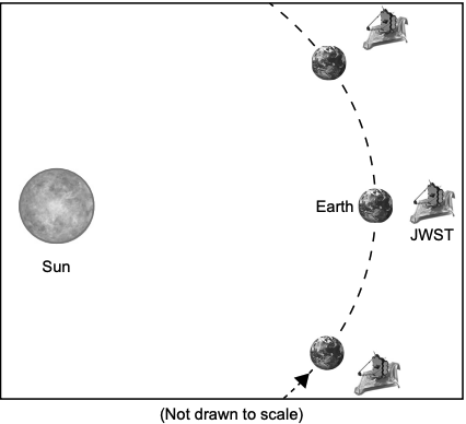
The James Webb Space Telescope (JWST) orbits the Sun in a complex path. This path allows the JWST to maintain a fixed location beyond Earth at an average distance of
On Earth, observing the infrared spectrum from celestial objects is difficult. Earth’s atmosphere blocks some of the infrared spectrum from space. This makes outer space the best place to observe the infrared spectrum.
Model of Some Orbital Positions of Earth and JWST
The JWST and the Hubble Space Telescope (HST) allow scientists to observe stars at various stages of stellar evolution. The table below shows some information for several stars observed by these two telescopes.
Stars Observed by the James Webb Space Telescope
Name | Spectral Class | Estimated Luminosity | Approximate Temperature (K) |
|---|---|---|---|
WD 1202-232 | A | 8400 | |
21 Lyncis | A | 9692 | |
Quyllur | M | 3500 |
From the Sun, the JWST average orbital distance and orbital velocity is approximately
Place a check mark (✓) in each row to identify whether each design criteria or constraint is a positive or negative trade-off of the development and use of the JWST.
Positive Trade-off | Negative Trade-off | |
|---|---|---|
Ability to Detect Older, More Distant Objects | ||
Access for Repair | ||
High Development Cost | ||
Quality of Infrared Imagery |
Which explanation uses evidence from the JWST to support the Big Bang Theory?
Which statement about the formation of these elements during this event is correctly supported by the evidence from telescopes?
Based on the model, which plate tectonic interaction led to the formation and eruption of Mt. Pinatubo?
Based on the Model of Geothermal Power Plant with Mitigation Components, which row in the table correctly identifies the step during which energy flows out of an Earth system and a step that mitigates climate change?
Row | Step of Energy Flow Out | Mitigation Step |
|---|---|---|
1 | 3 | 2 |
2 | 4 | 1 |
3 | 1 | 4 |
4 | 2 | 3 |
Which statements correctly identify the probability of how these natural hazards have influenced human activity?
Statement 1: Residents of Bronggang downgraded their probability of experiencing a pyroclastic fl ow after the 2011 hazard map was created.
Statement 2: Residents in Bronggang should install an early warning system sooner than the residents of Selo due to the predicted direction of pyroclastic flow.
Statement 3: An early warning system is needed in Munitilan because it is within 15 km of Mt. Merapi.
Statement 4: Evacuation zones were developed based on the probabilities of pyroclastic fl ow directions.
Statement 5: Residents in Ngargomula should always evacuate when Mt. Merapi erupts because the community has the highest probability of being impacted by pyroclastic flows.
Mineral resources in New York State have allowed for the construction of facilities that produce cement. Which resource is correctly matched with the location where the resource is found and used to produce cement products?
Which statement identifies the relationship between two Earth systems that are affected by the production of concrete?
Choose two of the three Earth systems below that are influenced by the use of concrete in the development of urban areas.
Then, describe one impact of urbanization on the water cycle of each of the two chosen Earth systems. Include both the Earth system and its impact in your response.
Earth System choices:
Atmosphere
Hydrosphere
Geosphere
Earth System | Impact |
|---|---|
Which two statements identify constraints that would support the choice of traditional concrete over porous concrete?
Which factor most likely caused the movement of carbon dioxide gas from the lake downhill into the valley?
Using evidence from the infographic, which statement describes the best human response that would reduce loss of life due to a future release of the trapped carbon dioxide in Lake Nyos?
Complete the qualitative model below by selecting the letter for each dropdown choice in the correct space in the model to represent one pathway for the movement of carbon that was responsible for the increased levels of carbon dioxide in Lake Nyos water.
Choice | A | B | C | D |
|---|---|---|---|---|
Description | Carbon dioxide dissolves into magma | Carbon dioxide is released from carbonate minerals and rocks | Carbon dioxide leaks from rising magma and dissolves into the lake | Heat is applied to carbonate minerals and rocks |
Model of Carbon Movement
Carbonate minerals & rocks


Increased carbon dioxide in Lake Nyos water released to local atmosphere
Describe how the minerals within the rocks of the continental segment are different than those found in the oceanic segment of the region around the Cameroon Volcanic Chain. Use at least one specific mineral to support your description.
Which description best explains why self-sustaining degassing pipes are the best solution for reducing the risk of future outgassing events at Lake Nyos?
Which statement correctly describes the pattern of ages in the crustal rocks found in the model?
Plate interactions that cause plates to move also form features on Earth’s surface. Which table accurately identifies the process associated with the complex features found in the model?
Four tectonic processes listed below describe one stage in the cycling of Earth materials in the Mariana region.
Write the letter of each tectonic process in the correct sequence to describe the cycling of Earth materials from location Y to location X.
Tectonic Process | |
|---|---|
A | Eruption and solidification of lava |
B | Partial melting of oceanic crust |
C | Rising magma |
D | Subduction of the Pacific Plate |
Based on the model, which row in the data table below identifies the correct combination of location of formation, rock forming process, and rock name?
Row | Location of Formation | Rock Forming Process | Rock Name |
|---|---|---|---|
1 | A | Eruption | Granite |
2 | B | Solidification | Peridotite |
3 | C | Compaction | Conglomerate |
4 | D | Heat/pressure | Schist |
Base your answers to questions 42 through 46 on the information below and on your knowledge of Earth and Space Sciences. Some questions may require the use of the 2024 Edition Reference Tables for Earth and Space Sciences.
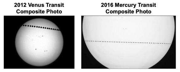
The transit of a planet across the disk of the Sun may be thought of as a special kind of eclipse. A transit occurs when a planet passes across the disk of the Sun. The time-lapse photographs below show two planetary transits across the Sun.

The data table shows some information about the transits of Mercury and Venus.
Dates of Planetary Transits
Transits of Mercury | Transits of Venus |
|---|---|
May 7, 2003 | June 8, 2004 |
November 8, 2006 | June 6, 2012 |
May 9, 2016 | December 10, 2017 |
November 11, 2019 | December 8, 2125 |
November 13, 2032 | |
November 7, 2039 | |
May 7, 2049 |
The Kepler space telescope used planetary transits to find planets outside our solar system. Kepler-16b was the first planet discovered in a binary star system. Binary star systems contain two stars. In this solar system, the stars Kepler-16A and Kepler-16B orbit each other.
Some Characteristics of Kepler-16 Stars
Star | Approximate Surface Temperature (K) | Luminosity |
|---|---|---|
Kepler-16A | 4500 | 0.14 |
Kepler-16B | 3300 | 0.005 |
The graphs below show some information about the apparent dimming of the stars Kepler-16A and Kepler-16B as planet Kepler-16b transits them.

Which piece of evidence explains why Mercury and Venus are the only planets in our solar system that transit when viewed from Earth?
Which evidence-based statement explains why Mercury has more transits of the Sun than Venus for the same time period, as viewed from Earth?
Based on the characteristics of Kepler-16A, which row best describes the nuclear fusion occurring within this star, and correctly identifies a star that has similar characteristics?
Row | |
|---|---|
1 | Fusion of helium directly to hydrogen; similar to Lacaille 9352 |
2 | Fusion of hydrogen directly to helium; similar to Cygni B |
3 | Fusion of hydrogen directly to carbon; similar to Alpha Centauri B |
4 | Fusion of hydrogen directly to helium; similar to Gliese 725 B |
Which statement correctly describes the physical and chemical properties of the basalt in the Siberian Traps?
Which table identifies the correct relationship between two Earth systems and how they are changed as a result of the mining for nickel?
The nickel deposits in Norilsk are found in the same mine with large deposits of copper, cobalt, and platinum. Nickel is rarely found as a resource in New York State. Which row correctly identifies the mineral deposits that are found with the nickel deposits in New York State and the processes that most likely formed these deposits in New York and in Norilsk, Russia?
Row | Mineral Deposits Found with Nickel | Geoscience Process | Norilsk, Russia Process |
|---|---|---|---|
1 | Zinc and lead | Recrystallization | Lithification |
2 | Wollastonite and rare-earth elements | Lithification | Recrystallization |
3 | Iron and rare-earth elements | Recrystallization | Crystallization |
4 | Talc and carbonate rock | Crystallization | Recrystallization |